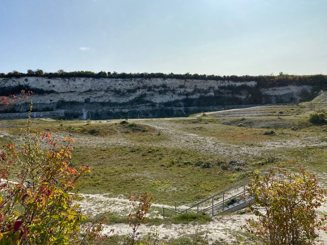
 Cherry Hinton Chalk Pits (East Pit) November 2020 Cherry Hinton Chalk Pits (East Pit) November 2020
UPDATE: April 2024 - War Ditches Report Attached at the end.
I thought I'd give you a little information about the War Ditches, Cherry Hinton, Cambridge, as I am publishing my book on the site soon and so little is publicly known about the history of the site.
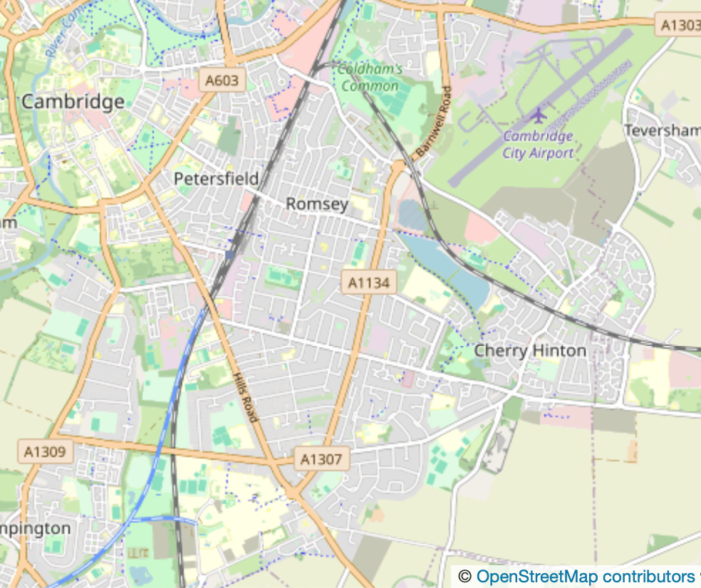
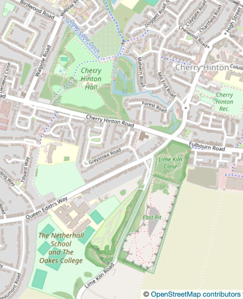
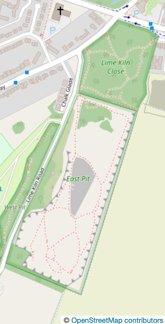
The War Ditches is an iron age hill fort site in Cherry Hinton, southeast of Cambridge City. The site, now almost completely destroyed by chalk quarrying, sits at the top of the most north westerly point of the Gog Magog Hills, on Lime Kiln Hill. The whole site has been occupied since prehistory and all periods are represented by activity on and around the immediate area. Today the site is within the old chalk quarry, now officially called 'East Pit'. It is managed by Cambridgehire Wildlife Trust and is open to the public for free.
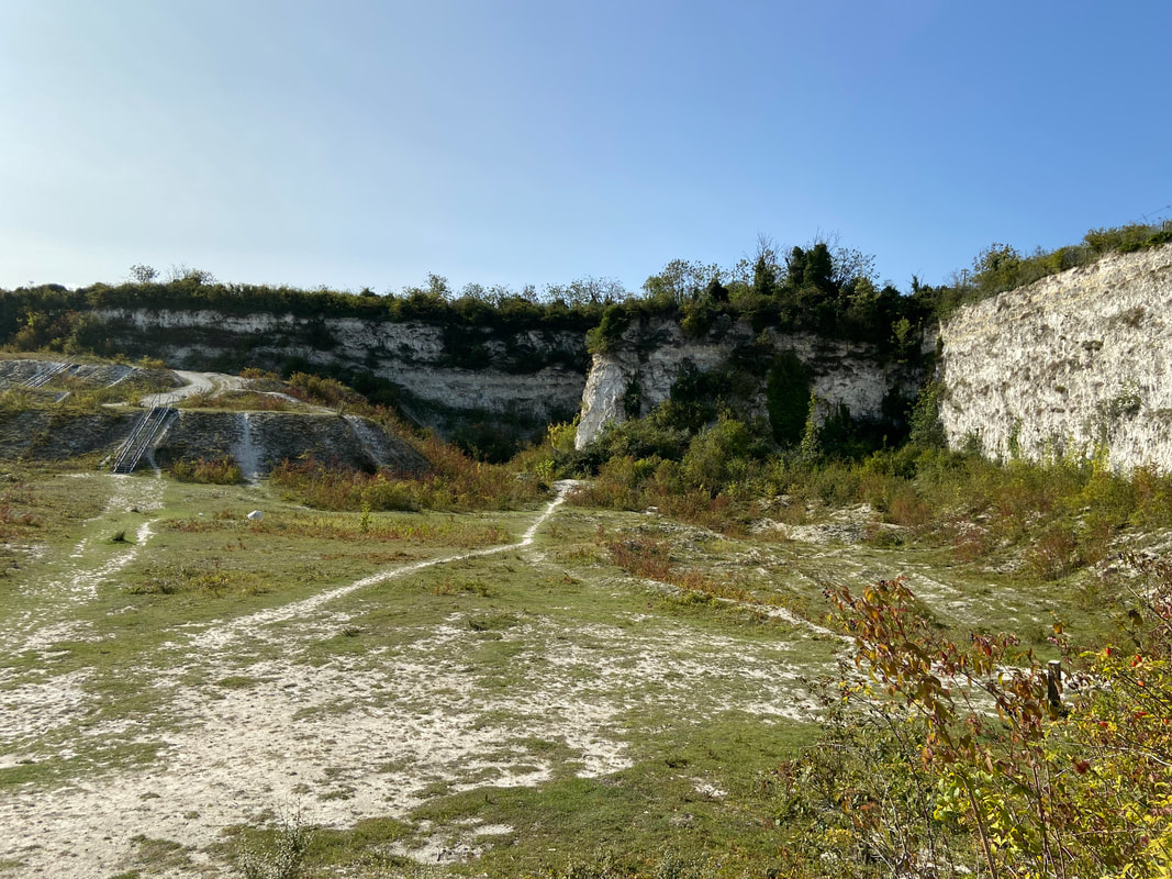
Cherry Hinton Chalk Pits (East Pit) November 2020
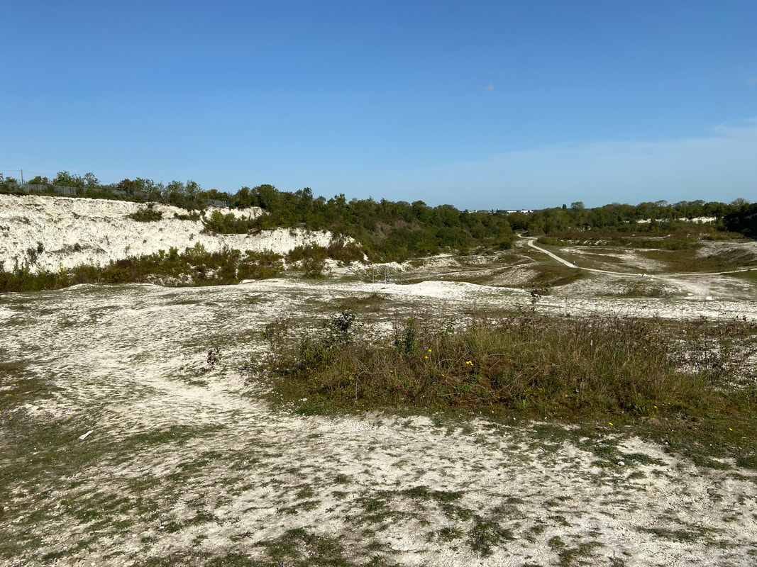
Back in 2008 I was out for a walk with my sister and my daughter, we were climbing around in the local chalk pits, which were, back then, a bit wild and not really managed. Us locals would go there to walk, play and explore the massive open chalk pits, which made you feel like you were in some jurassic time slip. Many people in the area today still do not know of this amazing site and if they stumble across it they are amazed it is there.
Cherry Hinton Chalks Pits (East Pit) November 2020
Cherry Hinton Chalk Pits (East Pit) November 2020
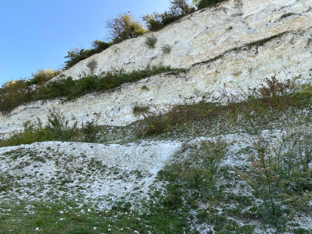
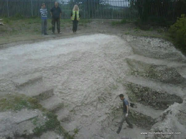
Anyway, back in 2008 on our walk at the chalk pits, we were up on the cliff side (you can't go up on the cliffs anymore!), we were sitting in a small dip and as I poked about in the mud, hand fulls of amazing ancient pottery sherds started to come out. I was Parish Archaeological Warden at the time and knew the history of the area well. We were sitting on the edge of the cliff where chalk quarrying had made a massive deep area and cut away all that had been there previously (see pictures). 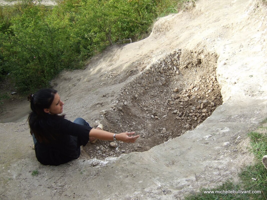 My sister sitting in the small dip, on top of the cliff, in Cherry Hinton Chalk Pits 2008 - filled with ancient pottery - part of the War Ditches rediscovered that afternoon. My sister sitting in the small dip, on top of the cliff, in Cherry Hinton Chalk Pits 2008 - filled with ancient pottery - part of the War Ditches rediscovered that afternoon.
In the late 1800's there had been reports of all kinds of things being discovered on the site and over the years various excavations had taken place alongside the ever encroaching quarrying - all manner of amazing well known antiquarians had been to and worked at the site over the years. The main discovery was that of the 'War Ditches' - a roughly circular ring ditch which was described as being an Iron Age Hill Fort, that had once dominated the top of Lime Kiln Hill - something like that of its neighbour of Wandlebury which is still preserved today, a couple of miles to the south west.
There had been various reports written about the site and the excavations that took place over the years and when the quarrying at the site had finished in the 1970's, the War Ditches was thought to have been finally and fully destroyed by the quarrying, it was written up in books and histories stating that fact. However, I was now armed with a bag full of beautiful pottery sherds dating from the late Iron Age, Romano-British and Roman periods. I knew the position of where the War Ditches had been and I also knew that where we had been sitting, in that small dip on the cliff side could only be one thing - an unknown remaining part of the War Ditches..... 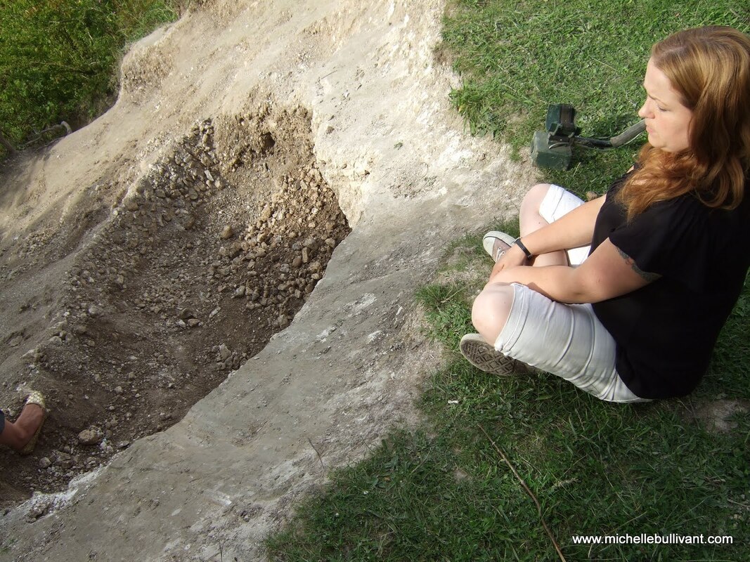
Me sitting at the small dip, on top of the cliff, in Cherry Hinton Chalk Pits 2008 - filled with ancient pottery - part of the War Ditches rediscovered that afternoon.
I quickly phoned my two friends and colleagues Mark Hinman & Richard Mortimer, both of who take an interest in the archaeology of this area, and told them what I had discovered and then drove the bag of pottery over to them for them to have a look. A lot of things happened fairly fast after that. Firstly, we found that the site was in the process of being acquired by Cambridgeshire Wildlife Trust from one of the Cambridge Colleges. Then it turned out that the chap involved with the Wildlife Trust and the acquisition of the site, lived close by. So Mark and I had an emergency meeting with him, at the top of Lime Kiln Hill where we explained what had been discovered. Mark moved quickly, explaining that a full and official archaeological excavation would be needed. Terms were negotiated between The Wildlife Trust, English Heritage and others and the business of the full archaeological excavation was taken on by Oxford Archaeology East (based in Bar Hill Cambridge, this company used to be Cambridgeshire County Council Archaeological Unit). Mark and I also approached Cambridge Antiquarian Society (of which we were both council members of at the time) to tell them of the discovery. Many of the past excavations at the site had been published by the Cambridge Antiquarian Society, since the 19th Century.
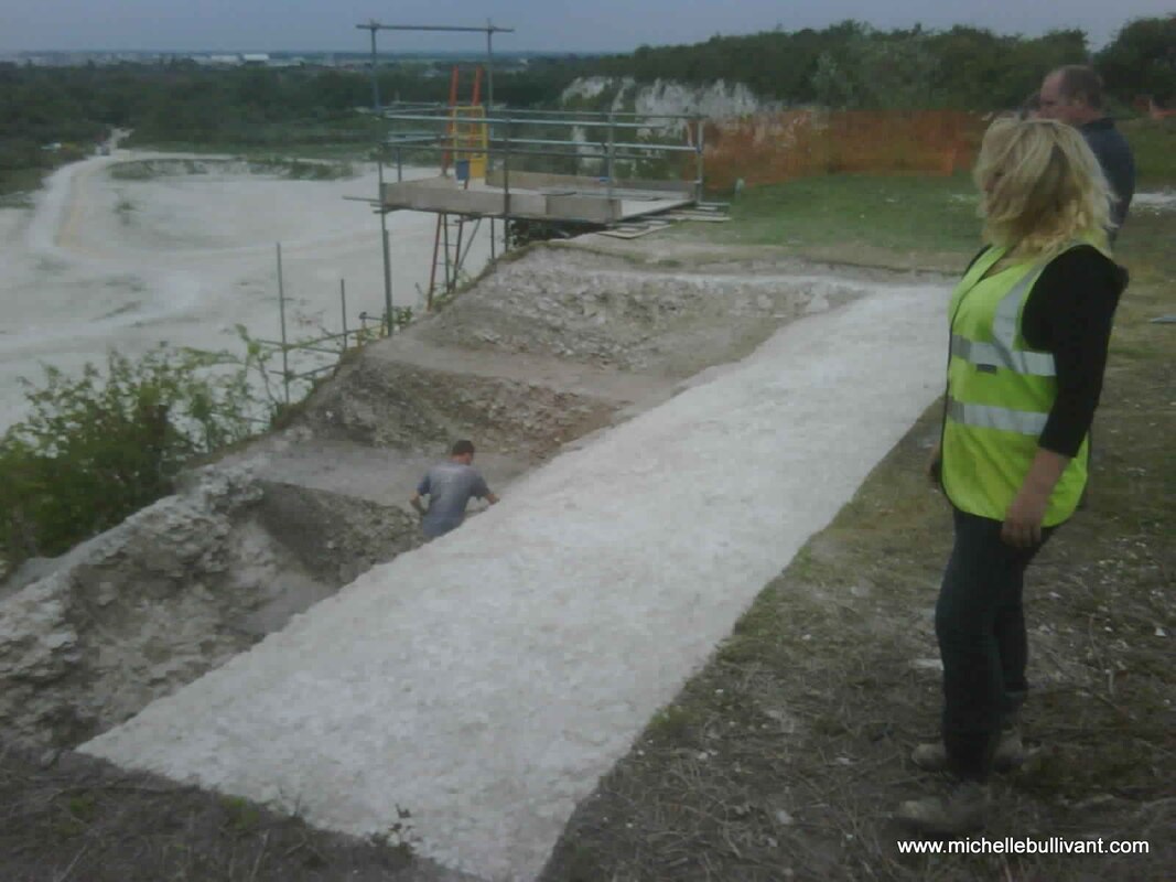
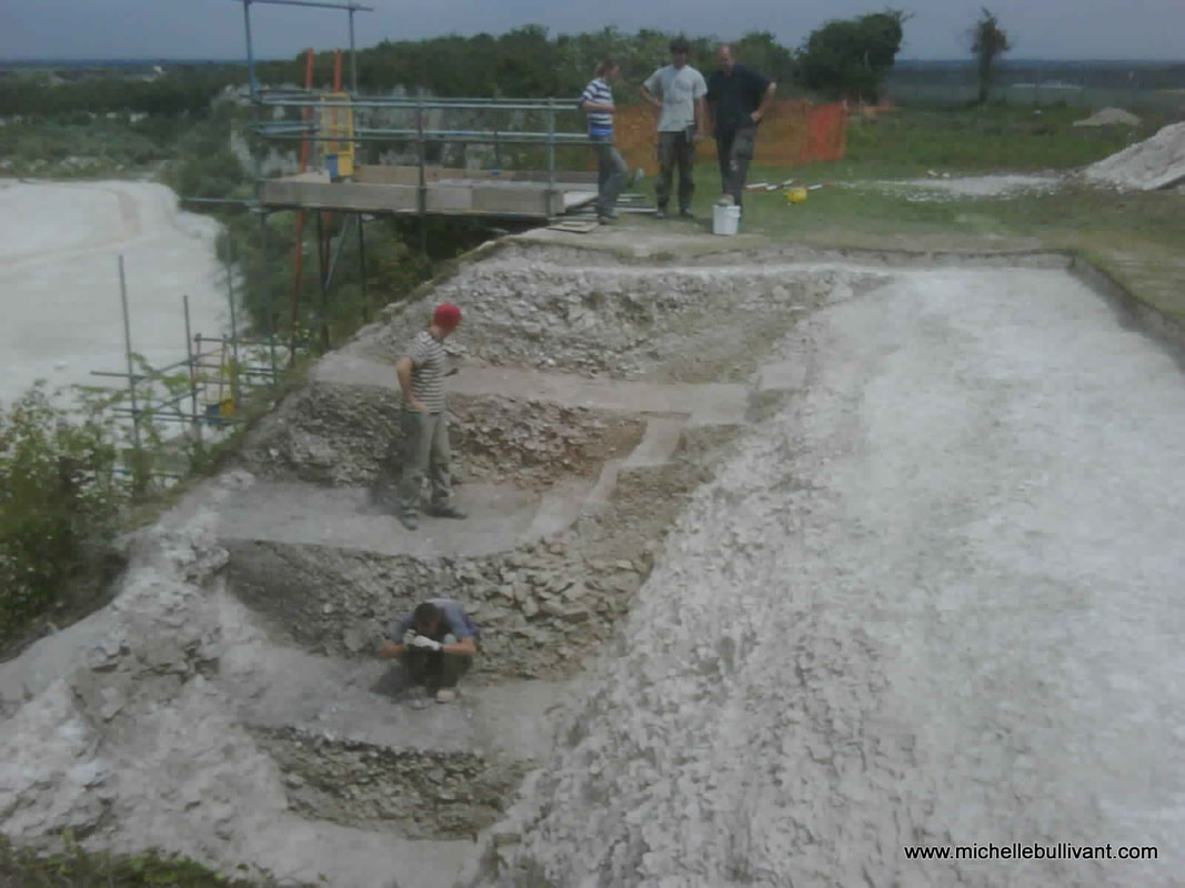
Archaeological Excavation at the War Ditches 2010. I am wearing the yellow viz vest and Richard Mortimer is standing behind me. The hole that I discovered was now opened up into what was a massive, ancient, ring ditch.
While negotiations and preparations for the archaeological excavation were taking place, I then had a phone call from the Cambridge Archaeology Office to tell me that two young boys who had been playing up at the chalk pits had found some human leg bones which had fallen out of the cliff, it wasn't clear which part of the chalk pits these bones were found - it could have been anywhere along the entire cliff. I was asked to pop down to the archaeology lab in Downing Street, Cambridge and collect the bones. A odd experience, which involved me collecting a pair of leg bones in a wooden box, which I then strapped into the front passenger seat of my car. I decided that the best thing was, that as Oxford Archaeology would be carrying out the main excavation on site, that I would deliver the legs to them to be processed by their finds department - even though they may not have fallen out of the actual War Ditches ring ditch itself, they still came from the same area.
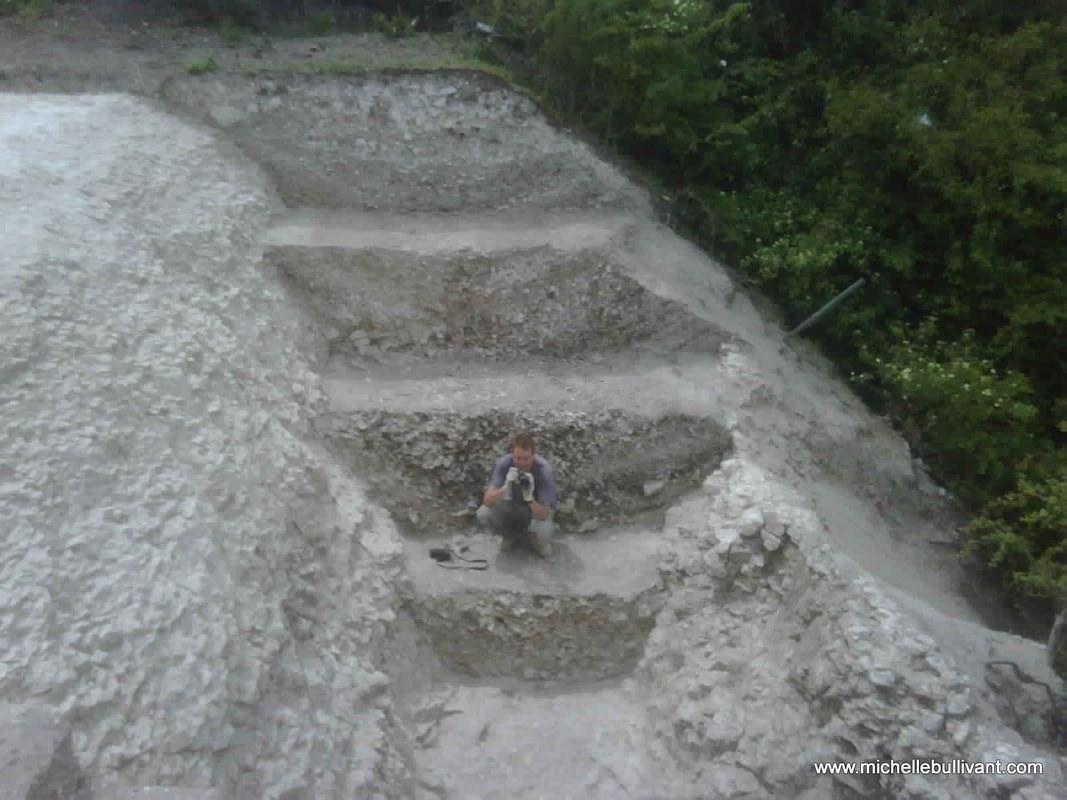
An excavated section of the War Ditches - the bright natural chalk to the left and the ancient ditch fill behind the archaeologist. Cliff face to the right of the picture. 2010
In 2010, the full excavation began in the chalk pits - this was something new for everyone, not least because Cambridgeshire is not known for its high hills or mountains but this excavation was on top of a cliff, so the archaeologists had to be trained in cliff side excavation and safety. A large scale scaffolding unit had to be erected next to the cliff to allow us to access the site safely and training in harness wearing was required for some.
Archaeological excavation at the War Ditches 2010, Cherry Hinton Chalk Pits
Obviously there is so much I want to write about what was found and the whole history the site but for now, I just wanted you to know what had taken place at the chalk pits because so many people have no idea that this site is there or anything about what happened. I will publish the book later this year and you'll be able to find out all the details of what was found both during this excavation and in the past at the site.
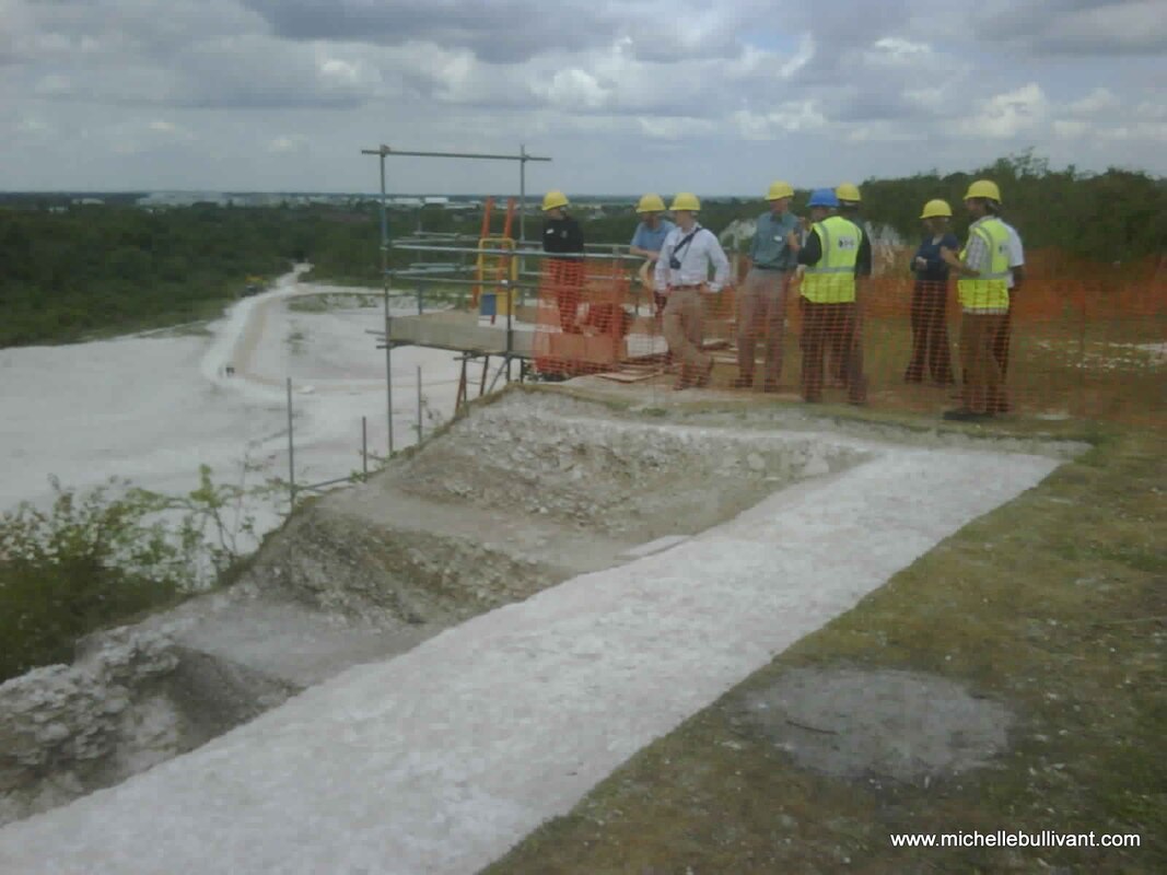
At the end of the excavation in 2010, an open day was held in the chalk pits. The Cambridgeshire Wildlife Trust now owned the site and had called this large chalk pit 'East Pit'. The mayor, press and public were invited to come and see the site and find out what had been taking place. Here are some more pictures from that day and the excavations 2010.
Archaeological excavation of the War Ditches, East Pit. 2010
Archaeological excavation at the War Ditches, East Pit 2010
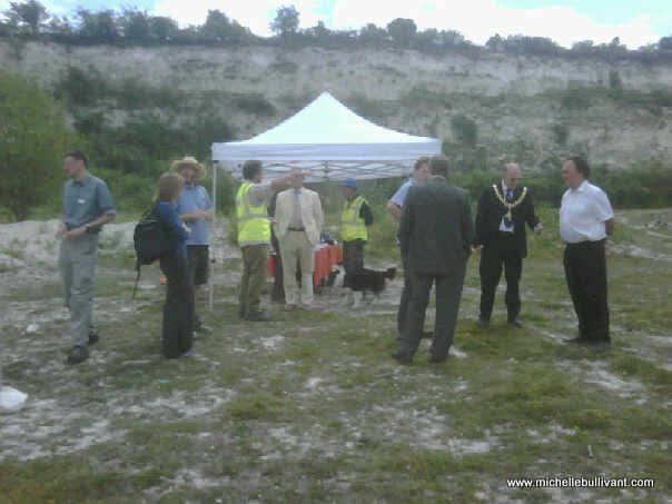
Open Day at East Pit, Cherry Hinton chalk pits 2010
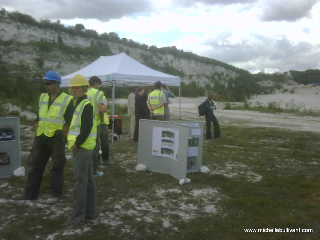
Open Day at East Pit, Cherry Hinton chalk pits 2010
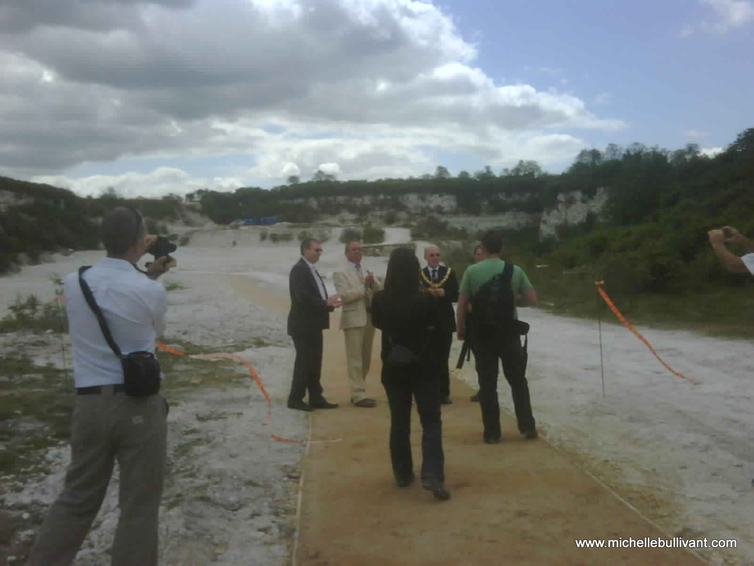
Open Day at East Pit, Cherry Hinton chalk pits 2010
Since the Wildlife Trust has taken over the site it has become a nature reserve and it is open to the public. There are also some display boards at the site for you to read.
As part of the excavation I was commissioned by English Heritage to write a report on the background and history of the site as part of the research into the site and subsequent write up of this new excavation. I took the opportunity to have a picture taken, to use for the cover of my report, with Mark and Richard, that mirrored a photograph of three of the antiquarians from the past, that had had a similar picture taken, it was a proud moment to be following in their footsteps. 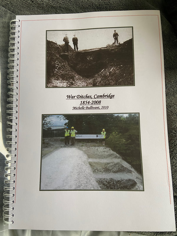
March 2024:
I have attached my report on the War Ditches below and in the downloads section in the main menu. This report is currently undergoing review and preparation for publication. As a temporary measure, it is provided here as a draft PDF for your reference and fair use. I believe it is essential to make such material available rather than risk it never seeing the light of day due to protracted publication processes or ongoing research endeavors, which may continue indefinitely if not managed carefully. Originally authored in 2010, it is high time that the valuable information and research contained within be accessible to others. I intend to update and refine it further before its final publication. I trust you will find it both informative and engaging in the interim.
If you'd like to support the work that I do, why not buy me a coffee, I'd be really grateful and it will help keep me going :)
5 Comments
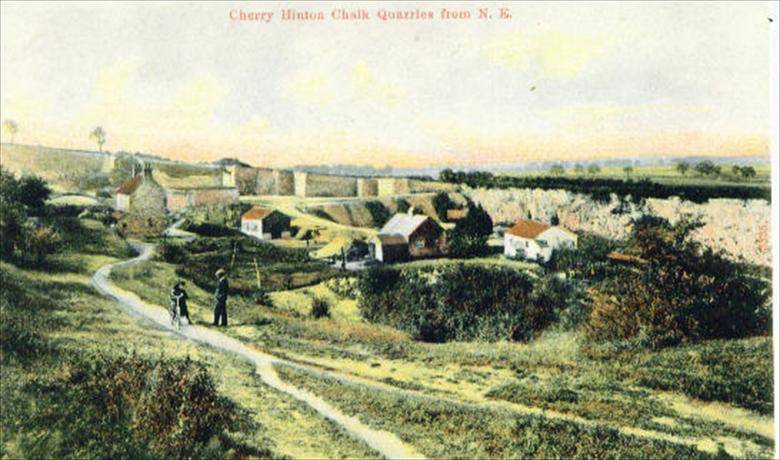 The Cherry Hinton chalk pits are on Lime Kiln Hill at the north western most spur of the Gog Magog Hills. The top of this hill comands impressive views across the town of Cambridge and beyond and as such has been an important site of settlement and defence since prehistoric times, an Iron Age fort known as The War Ditches was discovered on the site in the late 19th century. The quarrying and industrial use of the site has gone on from at least Roman times due to the high quality chalk and clunch (superior chalk). Cherry Hinton clunch was used, during medieval times, in buildings such as Ely Cathedral and the Cambridge Colleges. Quarrying and lime burning at the site continued at the site well into the 20th century.
A little exploration into one of the old farms of Cherry Hinton. Ventress Farm was one of the old farms that stood in Cherry Hinton village, positioned just off of, what is now, Cherry Hinton Road. There would appear to be nothing remaining of it to see today...or is there?...
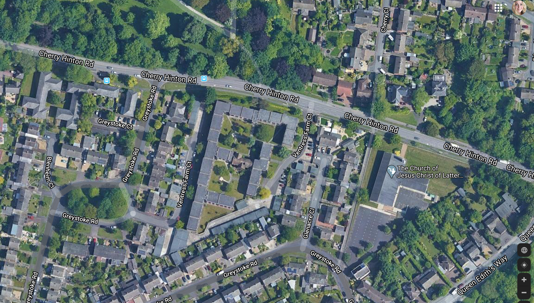
So as you can see from the two little video clips above, it may be that there is something of the old farm buildings remaining, that we can see today, hidden away from sight and only there if you go exploring and have a look. The question is, is that older looking house, within the more modern Ventress Farm Court Flats, actually the old Ventress farm house? or even on the site of the Ventress Farm. Given the name of the site today as Ventress Farm Court, it seems a fairly obvious clue that this was at the least the site of the old farm. So let's take a look at the things I can tell you about Ventress Farm, that I know of already and then see if we can decide if that house is, in fact the old farm house. Firstly lets get our position clearer in the landscape.
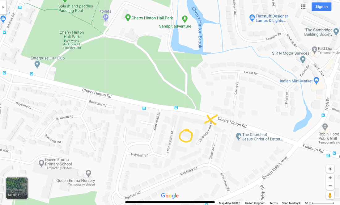
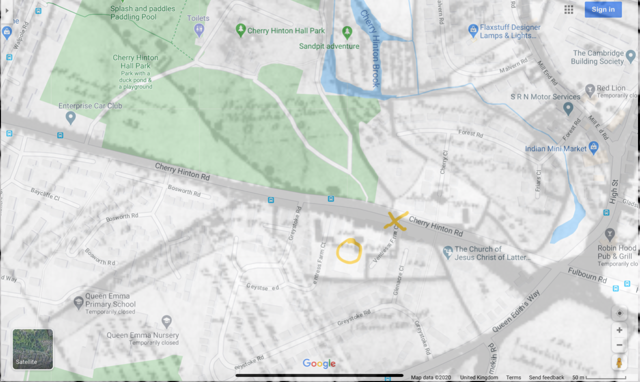
This is the southern end of Cherry Hinton. You can see the grounds of Cherry Hinton Hall top left and the blue pool is Giant's Grave, which is at the crossroads at the start of Cherry Hinton High Street, with the Robin Hood pub opposite bottom right corner. The yellow X marks the entrance to Ventress Farm Court and the start of video clip 1, the yellow circle marks the potential old Ventress Farm building in video clip 2.
A good place to start is the old Enclosure map of Cherry Hinton, which is from 1806, when Enclosure took place in Cherry Hinton (more on that in another blog coming soon). This is one of the earliest maps that we have for the village in any detail and we can get to see what buildings were there at that time.
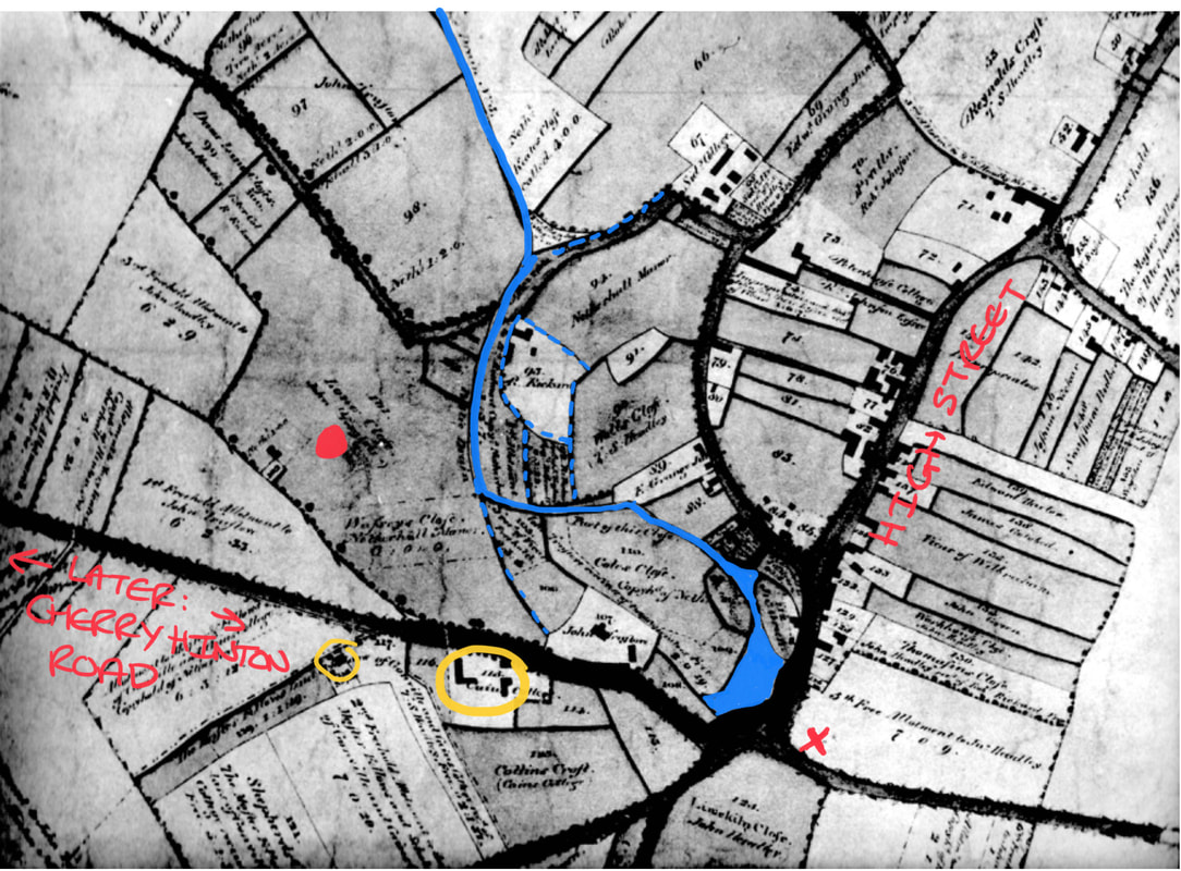
The Enclosure Map, 1806, of Cherry Hinton, showing the portion that we are examining. I have coloured in the Giant's Grave and the brook and marked two of the roads so that you might get your bearings. I have also put a red dot on the spot where Cherry Hinton Hall was to be built later, and a red X to mark where the Robin Hood pub now stands. I have circled in yellow the two sets of buildings on the road, around the area that Ventress Farm once stood.
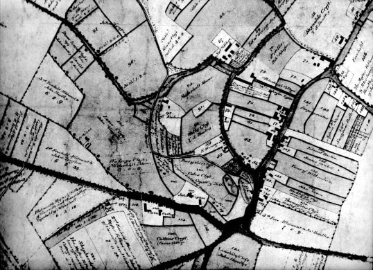
Here's the map unmarked for you. (Cambridgeshire Archives, Cherry Hinton Enclosure Map. Photograph M. Bullivant)
So in 1806, we can see that there are two sets of buildings around the site. The ones, in the larger yellow circle, look more like a set of related buildings which make them a more likely candidate for a farm and then the second singular building in the smaller yellow circle further to the left. Let's have a go at overlaying the modern map with the Enclosure map to see if we can sort the position out better.
The modern map laid over the Enclosure map of 1806, to give you an approximation of the buildings that may be the building that we can still see today.
Hopefully you'll be able to make out a little of what is showing through the overlaid maps above. We can now rule out the building shown previously, in the smaller yellow circle, and turn our attention to the collection of buildings, within the plot of the larger yellow circle. As you can more or less make out in the overlaid maps above, the left hand L shaped building seems to lay beneath what is now a road way - (the second part of Ventress Farm Court roadway, which comes off of Greystoke Road). The building that is shown on the picture above, in the yellow circle above is the one to focus on. If it is not the building that remains today, it would have stood upon the same spot and may relate to those bricks that were reused to make the back wall, shown in video clip 2.
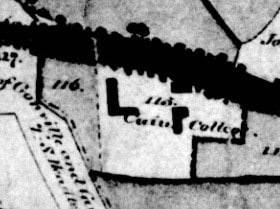
Close up of the buildings in our plot on the 1806 Enclosure map
As you can see there are two L shaped buildings within this one plot, numbered 113, and marked as owned by Caius College. In fact look a little closer within the plot and you'll see another small, square building, by the roadside. The dark line going across the picture is where Cherry Hinton Road now lays (this used to be called Long Drove). It does not name the site as Ventress Farm on this map. I need to do several things to make this information clearer at this stage but given the lockdown that we are in, some things will just have to wait until another day - one of which is a trip to Caius College to have a look in their archives, as it will be good to see what they have on Cherry Hinton in general but also to see what this site was called in previous years to the Enclosure. I also need to pop back up to Cambridge Archives, which is now in Ely, in its new building there, and go over both the Enclosure and accompanying pre-Enclosure maps of Cherry Hinton, getting some new and clearer pictures of them to share with you. I will then also be able to look through the Enclosure award book to see what and who else may be listed, for the plot that we are looking at. I do have all these records here but hidden in piles of archives, in boxes, so it's just as well to go and get some newer pictures with better camera. As I get more data I will keep adding to this post.
In the old medieval open field system within the parish of Cherry Hinton, the site lay in a large parcel of land called Fendon Field. The written survey, of parts of the village in 1592, by Christopher Saxton, describes many of the smaller parcels of land within Fendon Field, most of which are owned by Gilbert Wise and his family but it doesn’t mention any buildings, only the size of the land parcels. The same can be said for the survey of the land carried out in 1733 by John Tracey, some of the land within Fendon Field still being owned by the Wise family, descendants of Gilbert Wise.As we've just seen, on the Enclosure map of 1806 we can see that Gonville and Caius (Cambridge College) are marked as owning the site. Here's a little more information relating to that for now.
“In 1503 Thomas Willows granted c.45 acres to Gonville Hall (Cambridge), to which in 1708 W. Peters left 66 acres copyhold of Netherhall manor. After inclosure [1806] Caius College's main Hinton holdings were in Fendon field… Between 1830 and 1857 its land was leased out to William Ventris. Its lands were sold off piecemeal in the 20th century, and in 1998 it retained 20 acres....In account of Caius' building expenses between 1564 and 1573, amounting to £1,837, includes purchase of timber-trees from Warboys and Ramsey woods, freestone and rubble from Ramsey [Abbey] and Barnwell [Priory], freestone from King's Cliffe and Weldon, clunch from Haslingfield and Barrington and lime from Reach and Cherry Hinton.” “From the 16th century Caius College owned other lands in Teversham, called WILLOWES. In 1502 Thomas Willows, a Cambridge glover, had devised his purchased lands, c. 79 a., in Teversham, Fen Ditton, Fulbourn, and Cherry Hinton, to Gonville Hall, for 99 years, to help maintain a fellow and bible clerk. The Teversham portion, which, with other land in Fulbourn and Fen Ditton, became Willowes farm.” [in Teversham] (A History of the County of Cambridge and the Isle of Ely: Volume 10, Victoria County History, London, 2002.)
The next thing we can do is to take a quick look at the site from the air.
Can you see our current building?
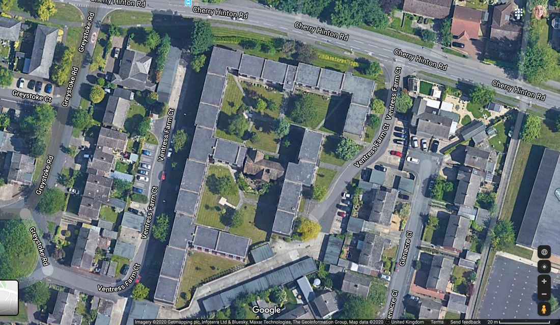
Zoomed in. Can you see it now? The older looking roof top in the middle of the modern roof tops of the flats in Ventress Farm Court.
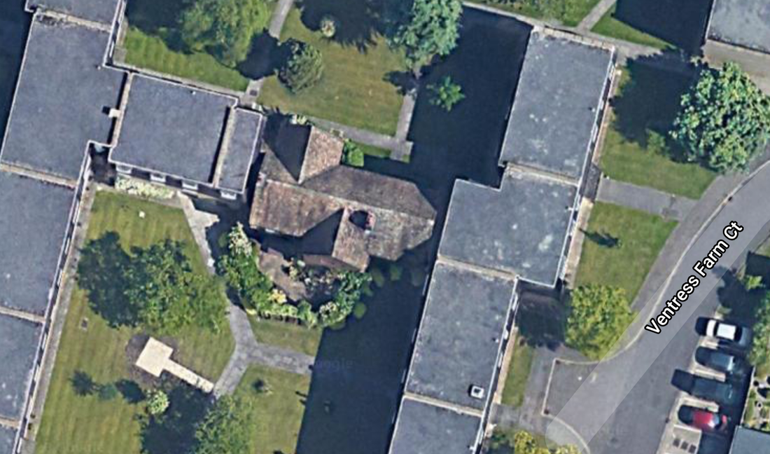
Last zoom in and now hopefully you can make out how old this building looks when seen from above - just look at that sitting there, right in the middle of the modern flats! Cool isn't it :)
So one last little thing to try before I start telling you about the tragic and interesting history from what I already know about Ventress Farm... let's overlay the Enclosure map with the aerial view to see just where that building lands, more or less ;)
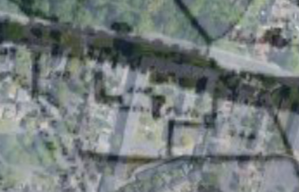
Here is the modern aerial overlaid onto the Enclosure map - not to clear to see really, is it? - here watch this next little video clip and then you'll be able to get your eye in better :)
Mr & Mrs Ventris lived and ran the farm on our site in the early 19th century, and it was called Ventris Farm - later, by the end of the 19th century the spelling had changed to Ventress. You can read more about the tragic incident that occurred, in 1813, to Mrs Ventris and her young child below:
The following is gleaned from old newspaper records about the Ventress (Ventris) family in Cherry Hinton and Ventress Farm:
Mrs Ventris, Relief of poor, May 1801 (Cherry Hinton Chronicle, E.Filby)
Relief of the poor in Cambridge and the neighbouring villages. Second subscription. Mrs Ventris, Cherry Hinton paid 10s 6d
Melancholy Event, September 24th 1813 (Cherry Hinton Chronicle, E.Filby)
We are much concerned in stating, that on Monday morning last, Mrs. Ventris, wife of Mr. Ventris of this place was found drowned in a ditch in the Parish of Cherry Hinton. She had left Cambridge on the preceding day, and took one of her children with her, a girl about 16 months old, who we regret to say, was also drowned, being found within a few feet of her mother. The Coroner's jury returned a verdict "found drowned".
This terrible thing happened and the verdict just seems so plain... 'Found drowned'. Perhaps it was as simple and as tragic as that. I presume that the ditch in question was most likely a point somewhere along the Hinton Brook, only across the road from Ventris Farm, which flows from Giant's Grave at the High Street crossroads, through the grounds of Cherry Hinton Hall and on towards Coldham's Common, before joining the River Cam at Stourbridge Common. You have to bear in mind that the Hinton Brook had far more depth and the area was covered in marshy boggy places, with natural springs and their little ditches cropping out in various places. This was before the drainage of the parish took place and before the water reservoirs were built on top of Lime Kiln Hill in the late 19th century, which in turn lessened the flow of water in the Hinton Brook. So perhaps it was just that, a tragic accident. It is natural to wonder if there was more to it such as foul play or even suicide, perhaps due to something like postnatal illness or such like but we can not presume or surmise anything like that because we do not have the full facts and can only give our respectful thoughts and prayers to the memory of Mrs Ventris, her young child and her family, acknowledging the sad incident, now part of our Cherry Hinton history.
I have started a family tree for the Ventris family, on Ancestry, so that I can get further records and information about them, which I'll add here as I discover facts.
Mrs Ventris was called Mary and she was buried, at Cherry Hinton, 23rd September 1813 (FHL Film No. 2149251)
The child, who died with her, was called Elizabeth Ventris, as she is shown as also being buried in Cherry Hinton on 23rd September 1813. (FHL Film no. 214251).
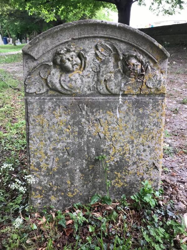
The gravestone of Thomas Ventris (possibly William's father) and the only Ventris gravestone I could find on my social distancing walk this afternoon, in St Andrew's Churchyard, Cherry Hinton. This little patch would have been the Ventris family grave area though. Back in around 2005, I, along with Graeme Clarke, surveyed the entire graveyard here and reproduced the grave plan and written grave records for the vicar at the time. I will dig that file out and check for more info on the Ventris family and put here later.
The main and only village burial site from the medieval period onwards was St Andrew's Church at the top end of the village in Church End - There was a large Saxon burial site further down Church End, pre-dating the main church today, which was discovered and excavated about 2009. Before that we've got isolated burials all over the place, from the skeletons of those massacred in long gone battles, found up on top of Lime Kiln Hill, at the War Ditches - to the boundary marker, bronze age burials around the parish and more besides. I'm not sure if the Baptist Chapel on Fisher Lane ever allowed any burials there but on the whole everyone was buried in St Andrew's Church yard - before the creation of the Cambridge Cemetery on Newmarket Road. I have long thought that there may have been some earlier, collective burial site, down the south end of the village (Mill End) somewhere, because Church End (in the north) and Mill End (south) were quite separate from one another before drainage took place in the late 1800's. Perhaps there is still a Saxon burial site to be discovered in Mill End somewhere - the only indication of something religious down that end at the moment, is an odd reference to "God's House" which keeps cropping up on old surveys and documents - it seems to lay somewhere off of the High Street, opposite the Post Office, in that area. So much to explore and discover still...:)
You can visit the tree that I have now started on Ancestry, to learn more about the Ventris family by clicking this link: www.ancestry.co.uk/family-tree/pt/RSVP.aspx?dat=MTY5MDQ0MzkwOzswMWU5NDJkNS0wMDA2LTAwMDAtMDAwMC0wMDAwMDAwMDAwMDA7MjAyMDA1MTIwNzE3MDI7MQ==&mac=KJIo8AoL8hQtxxf6g8vMBA==
The basics are: Mr Ventris was William Richmond Ventris and he married Mrs Ventris - Mary Lawrence in Cambridge on 28th December 1796 at Saint Andrew the Great Church. Mr Ventris was born around 1765 and his parents were from Teversham. He was married first to Martha Plume (born 1764 - died 1788) and they had 2 or 3 children together. He then married Mary and they had 4 or 5 children together. William and Mary had a baby called Sarah in June 1812 and who was then buried in Cherry Hinton in June 1812. Mary and her daughter Elizabeth died the in September 1813 - the newspaper article saying that Elizabeth was about 16 months old - I wonder if Sarah and Elizabeth had been twins? - a quick check of the records confirms this to be the case, as both Elizabeth and Sarah are baptised together in Cherry Hinton on 6th June 1812. William and Mary's son, Edward Ventris (b.1802 -d.1886) went on to live in Cambridge (3, Bateman Street, Cambridge) and was the Vicar of the parish church in Stow-Cum-Quy. William Ventris died in 1827.
More newspaper clips and information regarding Ventris Farm:
27th September and 4th October 1816 (Cherry Hinton Chronicle, E.Filby)
Parish of Cherry Hinton in the County of Cambridge Whereas the GAME within this Parish has been much destroyed by poachers and unqualified persons, and considerable damage done by persons sporting amongst standing crops and other acts of unsportsmanlike conduct, obliges us to adopt this mode of proceeding. We the undersigned being owners and occupiers of Lands within the said parish, do hereby give notice, that such persons found trespassing will be prosecuted, and qualified persons are requested not to sport. T.S. Headly, R. Johnson, R.Rickard, R.Emson, W.Capp, J.Barrance, R.Granger sen., R. Granger jun., J.Truslove, John Headly, John Green, W.R. Ventris, William Tagg, Thomas Hart, J.Clements, William Coe.
October 15th 1819 (Cherry Hinton Chronicle, E.Filby)
Furniture - Cherry Hinton To be sold by auction by Elliot Smith on the premises of Mrs Ventris, deceased, on Tuesday next the 19th October at 2 o'clock in the afternoon. Consisting of bedsteads and furnishings, beds and bedding, 8 day clock, a bureau, corner cupboard, kitchen utensils, hooks and various other articles. May be viewed morning of sale. Catelogues to be had at the Coach and Horses, Fulbourn, Red Lion, Cherry Hinton, and Elliot Smith.
January 1st 1822 (Cherry Hinton Chronicle, E.Filby)
Inquest On Friday last, an inquest was held before John Ingle Esq., one of the coroners for this County, on view of the body of Thomas Lane, servant at Mr. Ventris's farm, at Cherry Hinton. It appeared that the deceased, who had been unwell for some time, but not so much so as to prevent his going about his usual avocations, retired to bed after eating a hearty supper. In the night a person in the adjoining room was awoke by the cries of a lad, who slept with the deceased. He immediately got up and only arrived in time to see the poor fellow expire. Verdict, died by the visitation of God.
September 14th 1832 (Cherry Hinton Chronicle, E.Filby)
Theft On Sunday night last or early on the following morning, a post chaise was stolen from the premises of Mrs. Ventris of Cherry Hinton.
October 21st 1882 (Cherry Hinton Chronicle, E.Filby)
MILK! MILK! J.Barton will supply Daily pure MILK from the cow 8 pints for 1 shilling. Deliveries to all part of the Town. All orders received at Ventris Farm, Cherry Hinton.
Owners and occupiers of Ventris (Ventress) farm over the years:
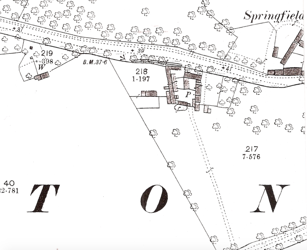
The 1888 Os Map (https://cherry-hinton.ccan.co.uk/content/catalogue_item/map-of-1888) showing Ventress Farm, as a collection of buildings in a square layout. P. indicates a pump and our building that stands today is upon the spot along the southside of this complex. Notice how the little building on the far left, which was shown on the 1806 Enclosure map, still stands.
Both the 1851 and 1861 Census do not record Ventris Farm by name but records a John Spencer as a farmer in the vicinity of where Ventris Farm would have been, on Cambridge Road (called Fulbourn Road 1861) - but we can not say for certainty that this is the same site, so for now we'll just note that, rather that say for definite.
In the news, which may relate to Ventris Farm, if Mr Spencer did indeed farm and live there, the following entry in the Cambridge Chronicle appears:
November 17th 1849 FIRE! On the night of Tuesday last, about 12 o'clock, a fire broke out in a wheat stack situate in a field on the farm of Mr. Spencer, of this parish. The flames speedily communicated to a contiguous wheat stack and a barley cob, and the three were reduced to ashes. The stacks were at some distance from the Homestead and there is no doubt that they were maliciously fired. The conflagration, from the solidity of the Stacks, lasted for a considerable period, and created a great deal of alarm in Cambridge. Mr Spencer is insured, but we have not heard an estimate of the loss, which must be considerable. (Cherry Hinton Chronicle, E.Filby)
Both the 1871 and 1881 Census do not record Ventris Farm by name but records a Remmington Pratt as a farmer in the vicinity of where Ventris Farm would have been, on Cambridge Road - but we can not say for certainty that this is the same site, so as with 1851 and 1861 previously, for now we'll just note that, rather that say for definite.
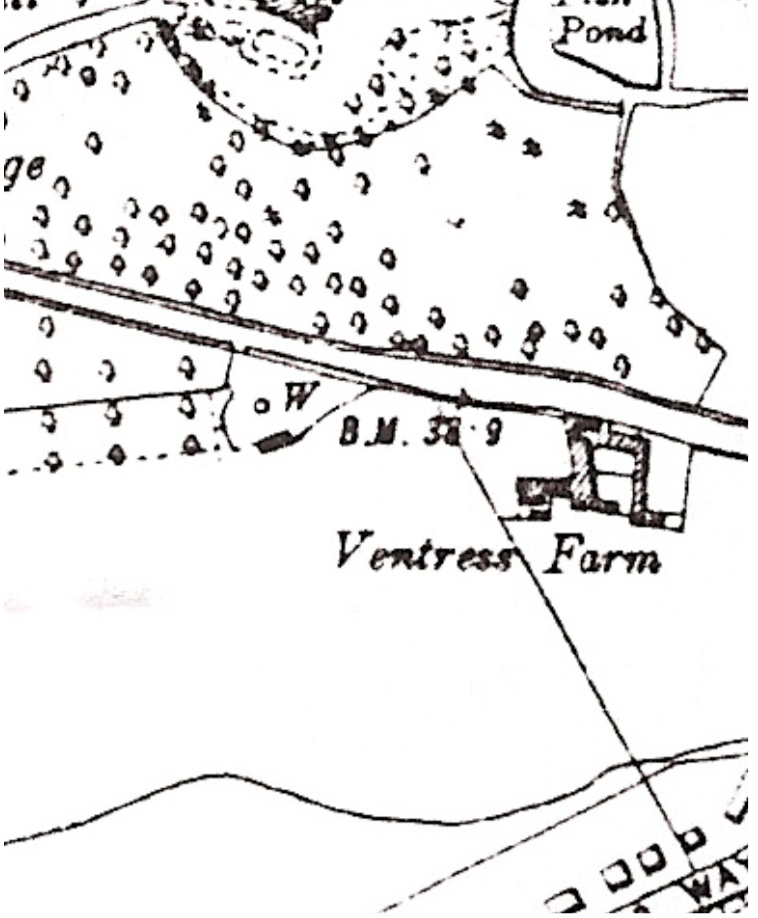
OS Map, 1950 (https://cherry-hinton.ccan.co.uk/content/catalogue_item/map-of-cherry-hinton-1950) - showing Ventress Farm buildings and still the other small building to the left, remains standing.
OS map 1885 shows the name spelt Ventress rather than Ventris.
On the 1891 Census, Ventris Farm isn't named but approximately where it would be expected a farm is listed but called Barton's Farm - perhaps a temporary change? this needs more investigation. As it corresponds to the site, it is worth mentioning the details here:
Barton's Farm - James Bass, Head, married, aged 60, Farm Bailiff, employed, born in Oxford Emma Bass, wife, aged 61, born Bucks William Bass, son, single, aged 37, Book Cavasser, born Bucks Louisa Bass, daughter, single, aged 23, born Trumpington Walter Bass, son, single, aged 19, Stationary Engine Driver, employed, born Trumpington *note how the son, Walter is a stationary engine driver - this suggests that he was working for the Pamplin family of Cherry Hinton who ran the steam plough works (where there were stationary engines working the plough) in the village and are recorded as owning the Ventris Farm site in 1913 - perhaps they owned it from this date, 1891
The 1901 Census doesn't name Ventris Farm, just the road, but we can presume with some degree of certainty that Daniel Coe who is shown as Farm Baliff and is on the 1911 Census (see below) as a Farm Steward, living at Ventris Farm, is at the same place in 1901.
So for 1901 it is likely that the following applies: Cambridge Road, Cherry Hinton - Daniel Coe, Head, married, aged 48, Farm Baliff, worker, born in Cherry Hinton Emma Coe (Emily on 1911 Census), wife, aged 47 years, born Cherry Hinton and Lizzie Coe (Lucy on 1911 Census), daughter, aged 20, Dressmaker, born in Cherry Hinton Ada F Coe, daughter, aged 16, born Cherry Hinton Any other the families shown either side of the Coe's on this Census could also be living on the site but without a link we can not presume to add them at this point.
In 1909 a sad incident took place at the farm:
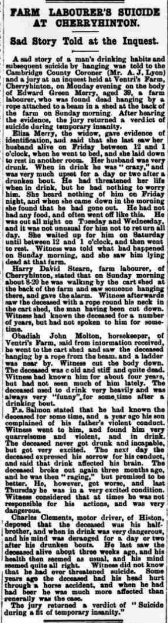
Cambridge Independent Press, May 14, 1909 (British Newspaper Archive)
On the 1911 Census for Cherry Hinton, there are three people listed as living at Ventris (spelt the original way) Farm, as follows:
Obdiah John Malting, head of the household, aged 52, married for 30 years, 3 children born alive, 2 living, one died. Horse keeper, worker. born in Suffolk. Caroline Malting, wife, aged 51, born in Suffolk and Harry Joseph Malting, son, aged 20, single. Born in Suffolk. The house is listed as having 4 rooms (not inc. any scullery, landing, lobby, closet, bathroom nor warehouse, office or shop)
Also on the 1911 Census, shown living as separate family (and most likely building with in complex) at Ventris Farm were:
Daniel Coe, Head, aged 59, married for 40 years, Farm Steward, Farmer, Worker, born in Cherry Hinton. Emily Coe, wife, aged 59, 5 children born alive and 5 children living, born in Cherry Hinton. and Lucy Coe, daughter, aged 30, single, dressmaker, born in Cherry Hinton
c. 1913 - The two farms at Cherry Hinton owned by Pamplins were Ventris Farm and Sidney Farm. Ventris Farm stood on the left of Cherry Hinton Road as you left the Robin Hood public house and made your way towards Cambridge, the farmhouse stood on the site that is now a brand new housing complex of flats called Ventress Farm Court. (M. Bullivant, Cherry Hinton Community Archives (CCAN). You can read more about the Pamplin Bros. here - https://cherry-hinton.ccan.co.uk/wp-search/ventris)
Harold Ridgeon and his family are living at Ventress Farm in the 1960's - a well known Cambridge family, involved with the Sindalls Company, which had a site further down Cherry Hinton Road, opposite Wulfstan Way.
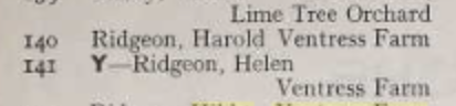
City of Cambridge Poll Book, 1960, (Cambridge Libraries and Archives)
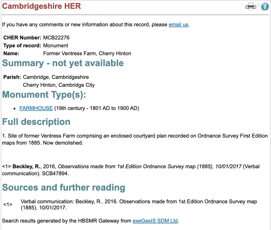
The record on the Cambridgeshire Historic Environment Record database is as follows:
Which we now know isn't quite correct, the farm isn't completely demolished. So I have written to them to request the record now be updated with the new information provided by this post. You'd never know it was there, unless you live in Ventris Farm Court and saw that odd building in the middle as different, or if you didn't just come off road and explore because it can not been seen from the road side at all.
Addendum.
This welcome comment was posted to this article by Ivan who said the following: "Not sure if you found it already but if you search for planning reference C/75/0116 on the greater Cambridge planning portal, you find : "Address: Ventress Farm House Cherry Hinton Road Cambridge Cambridgeshire. Proposal: Erection of two-storey extention to existing dwelling to from flats.Change of use of existing dwelling to flats". Dated 02 Apr 1975. The application was granted - maybe this is as straightforward as it sounds - the house was there at that time and was converted to flats then?" If you go onto the planning portal yourself, you will find the information he is referring to and you'll see that it does indeed give the date for which the flats we see today at Ventress Farm were approved for construction in 1975 and that it also says they are to be extended from the farmhouse that stood on the site. It also suggests that the house itself is converted to flats. Here's a screen shot of part of the original application: 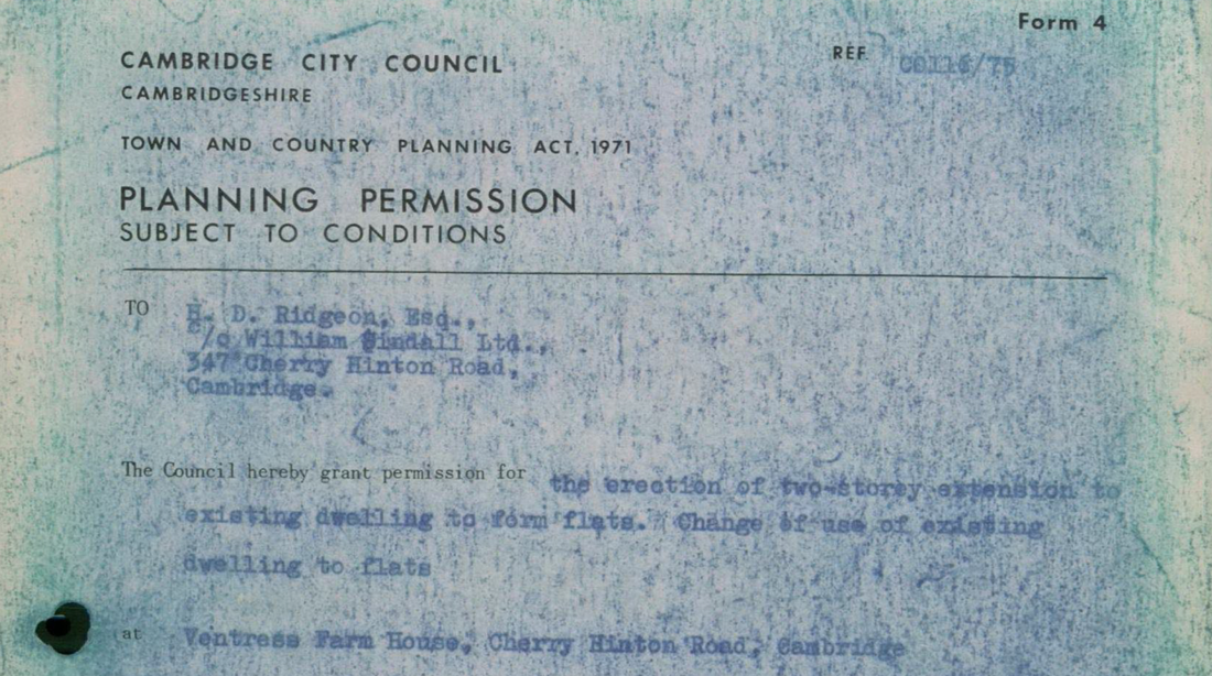
Many thanks to Ivan for this information - and remember, if you have any information you'd like to add or ideas you want to suggest please do get in touch. In addition, you are more than welcome to share you memories of Ventress Farm and the site, living in the flats and so on, to this site - just drop me a line :)
If you'd like to support the work that I do, why not buy me a coffee, I'd be really grateful and it will help keep me going :)
The Tutton (or Tottenhoe) Way is an ancient route-way that skirts the eastern edge of Cherry Hinton old parish, now Ward, and now also forms the eastern Cambridge City Boundary.
VIDEO 1 of 3 - Tutton Way
The Tutton Way, from the top of the Gog Magogs, on Worts' Causeway, opposite the Shelford Gap, looking down towards Cherry Hinton village and across Cambridge.
I can, so far, trace this boundary from the northern end of Bridewell Road in Cherry Hinton where it joins Fishers Lane, following through the back gardens and the line of this routeway south, to meet up with the small passage way at the other end of Bridewell Road, that leads through on to the Back Field, where it continues on in the form of a paved footway to join Fulbourn Road. It then crosses straight over Fulbourn Road and enters the northern boundary of the Gog Magog Hills, where it travels up through a field edge as a trackway, going first alongside the eastern edge of the Peterhouse Technology Park and then continues up over the hill, in a straight line, through the fields as a wide trackway (currently closed to the public). The Tottenhow Way then meets the Worts' Causeway Road at one of the highest points on the Gog Magog Hills, where, straight across the road, it continues, for a short way, as a wide trackway named the Shelford Gap before apparently ending at the thick hedge line beyond which the Gog Magog Golf Course lays. It also meets the apparent end of the Roman Road, collectively known as Worstead Street or Wool Street. The Roman Road leads off of the end of the Shelford Gap (Tutton Way) in a south easterly direction, in a long straight line for many miles.
VIDEO 2 of 3 - Tutton Way
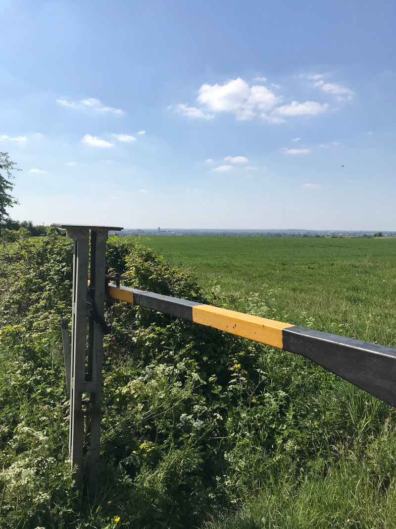
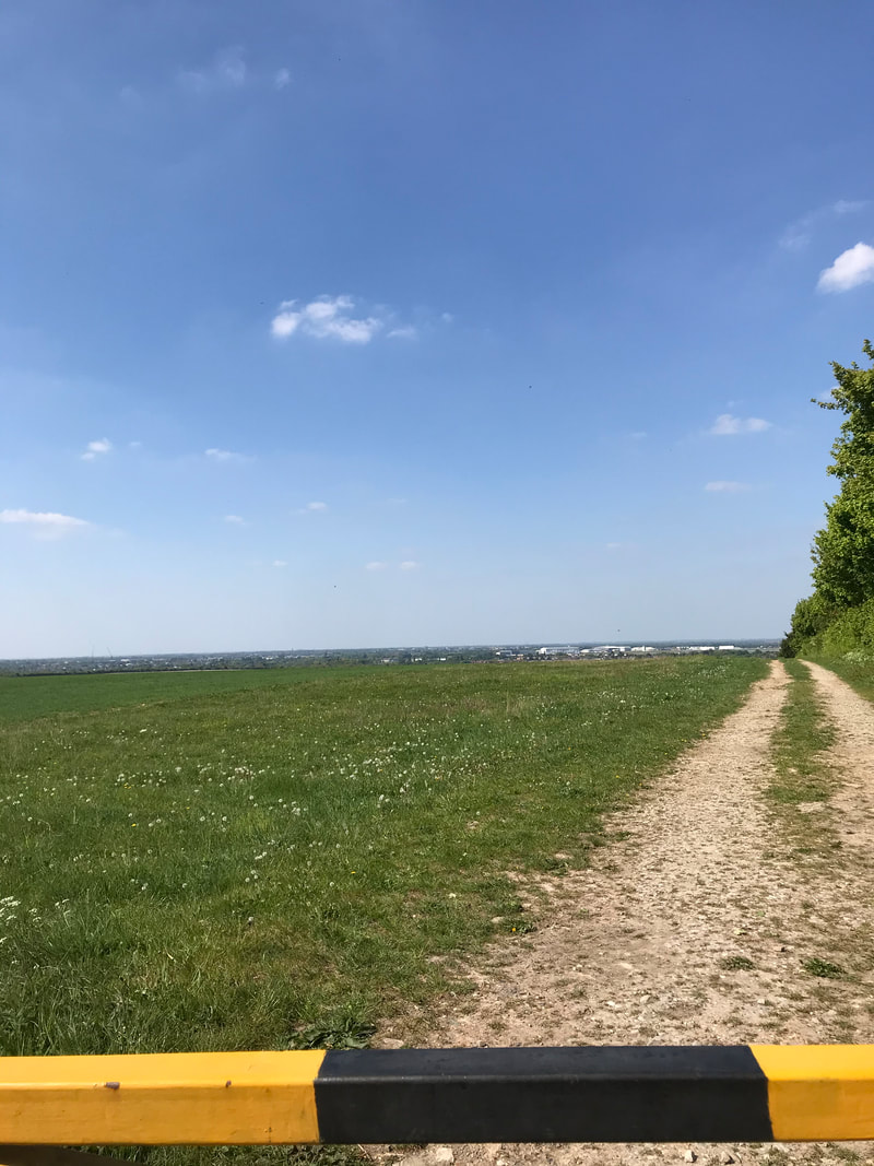
At the end of the Shelford Gap, looking north, toward the cars parked on Worts' Causeway. This is really an extension of the Tutton Way and this is the point where the Roman Road leads off to the right.
There is a little bit of a dirt track entrance/parking on the roadside by the start of the Shelford Gap on Worts' Causeway and barriers to prevent vehicles driving down the track but it is a popular place to start the walk down the Roman Road. However, it’s not very advisable to go there alone and there are, shall we say, interesting individual and collective, unusual activities that go on at that spot, particularly as there is a small wooded area alongside the trackway. It is not really very safe to walk up to this point as there is no real safe footpath from Cherry Hinton, so going by bike or car is currently the safest way.
From Cherry Hinton the route is taken, starting from the Robinhood at the junction of Cherry Hinton High Street and Cherry Hinton Road. Go straight over onto Queen Edith’s Way. Take the first turn on the left to drive over Lime Kiln Hill, at the immediate base of Lime Kiln Hill, where there is a crossroads. Take the next left to drive up Worts' Causeway, passing the Beech Woods on your right, continue up the hill until you reach the crest, where you will see the parking area for the Shelford Gap on your right hand side. You will be able to cross the road on foot to look north over the Tutton Way and see the spectacular views across Cambridge, Cherry Hinton and beyond. If it is a very clear day you will also be able to spot Ely Cathedral in the distance (about 20 odd miles away.)
Once you’ve finished your visit you can either go back the way you came or you can continue along the road eastwards, turning right, as you come out of the Shelford Gap on to Worts' Causway, where it then becomes Shelford Road. It will lead you over the hills, with lovely views, where you’ll also be able to see the sails of the Fulbourn windmill on your left as you make the descent down towards the village of Fulbourn. At the bottom of the road you’ll meet with Cambridge Road and mini roundabout, where you can turn left and follow the road straight back to the Robin Hood pub in Cherry Hinton.
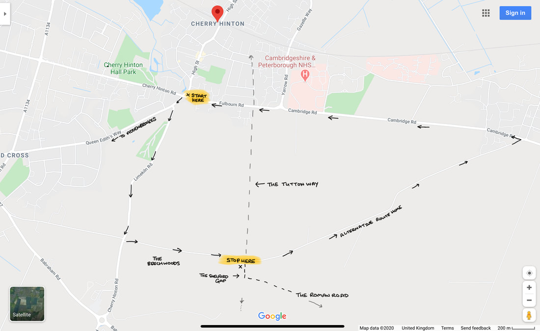
Directions to the Shelford Gap with the route of the Tutton Way, which is now a private road in part.
I think, on the whole, hardly anyone today knows about the existence of the Tutton Way, other than the people who remember me talking about it when giving local history talks to groups, where I would mention it now and then. I had found out about it from reading old documents, maps and surveys from Cherry Hinton when doing my research on the village over the years. Being stuck in isolation during the lockdown is giving me chance to write up a few things that I’ve been meaning to write about for some time, including the ever-allusive Cherry Hinton Local History book that I’ve been promising to write for years. So, I thought I’d start with writing about a few of the places you can walk to or get to, for nice walks and offload some of the information and theories about the archaeology and local history of the area, out of my head and onto paper/screen, with an idea to start forming the book that I must get done.
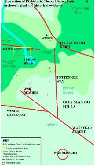
Prehistoric Cherry Hinton Map ©Michelle Bullivant 2010
The map above, that I made some time ago, gives you an idea of some of the routeways and sites in and around Cherry Hinton during prehistoric times. I have placed the current main church building of St Andrew's on the map just to help you get your bearings. You can see the Tutton Way (Tottenhoe Way) that we are discussing, you can also see the Roman Road and the projection of its, potentially earlier route. You can also see the hillforts of Wandlebury and the War Ditches. I also mapped out the (at the time) known burial (barrow) sites, showing their relationship to the routeways. It just gives you a basic illustration of the area that we are looking at and makes the point that you can often tell ancient (pre Roman) boundaries and route-ways as they are often have barrows and other markers along their course.
At the end of the Shelford Gap, near to where it meets the Roman Road, were once two locally known barrows, nicknamed the Two Penny Loaves: "Smith's carrier's cart turned right from Fulbourn, heading south into rolling countryside. All the way it creaked ever upwards, till at the top of a ridge they reached an ancient track which was apparently an old Roman road linking Cambridge with Colchester, the way marked by two barrows, called by local people the "Two penny loaves" (Pickwick's Cambridge Scrapboook 1838, Mike Petty) "At this point, where the road returns to its original direction, there are the remains of two tumuli, called the Two- penny Loaves, one of which was opened in 1778, and seven skeletons were found at its bottom ; six of them were laid close together and parallel, with their heads pointing due north, the other lay with its head directed due west, and its feet next the side of the nearest of the six (Nichols's Lit. Artec, viii. 631)" (Ancient Cambridgeshire, by Charles Babington, Cambridge Antiquarian Society) 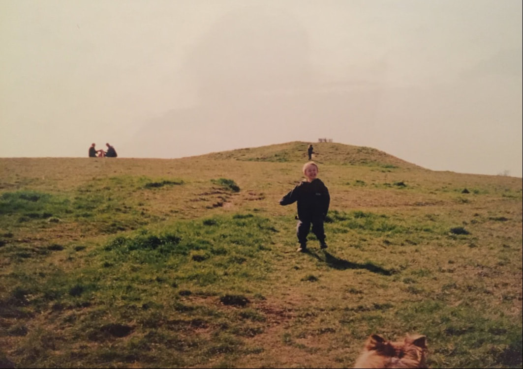
The picture above (with my son in the foreground and daughter climbing in the background, many years ago) gives you an idea of what Bronze Age burials mounds, or barrows as they are also called, look like. The one above is situated on Thurfield Heath in Royston, not that far away. You may often drive past them at the side of roadways and not realise what they are, a good example is of the one on the A11 as you drive towards Norwich from the 5 went ways roundabout at Barton Mills. The Two Penny Loaves would have looked something like this, standing side by side. However their fate, as with many of these barrows, was that they were excavated and destroyed, with the majority of barrows being ploughed away over the years to only occasionally be seen on aerial photographs as a crop mark on the ground. After lockdown, I will see if the Gog Magog Golf Club will let me go and have a look for the site of the Two Penny Loaves and report back to you if any sign of them remains.
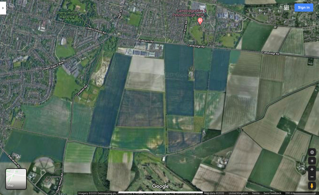
An aerial view of the Tutton Way and Shelford Gap. See if you can follow it's line from Fulbourn Road, where it runs alongside the end of the Peterhouse Technology Park, south to join the Shelford Gap.
One of the earliest descriptions that we have of the layout of some of the land in Cherry Hinton comes from a written survey of the Manor of Netherhall in the Parish of Hynton from 1592 (Separate articles on the Manors of Cherry Hinton and place names in the area soon). Unfortunately this survey, carried out by Christopher Saxton (you can read about him on Wikipeadia), is a written survey only with no accompanying map that we know of. This means we have to go by the written descriptions within the old open fields of the parish to work out where he is talking about.
The main open field that the Tutton Way traversed was called Quarry Field, it was a large area covering across from Lime Kiln Hill, on the Gog Magogs, eastwards to the parish boundary (the Tutton Way). Saxton gives the following description and land measurements:
"Quarry Field... The Furlong abutting the Totton Way - One piece lying in the lands of ..Junior South - 1 acre, 0 roodes, 5 dawks and 3 pches One piece laying between the lands of Uphall on the east and Gilbert Wise on the west - 0 acres, 2 roodes, 8 dawks and 2 pches" (London Metropolitan Archives, H01/ST/E/106/002) So here we see the first known written mention of the Tutton Way - spelt by Saxton, as 'Totton'
The next reference to the Tutton Way can be found in the Survey of St. Thomas' Hospital Land in Cherry Hinton, 1733 by John Tracey. (Survey of Hospital Propery at Cherry Hinton, by John Tracey, 1733. London Metropolitan Archives, H01/ST/E/107/003) which again was a written survey based within the old open fields of the parish but this time, contained three simple maps. One of which shows the route way, within Quarry Field, called Tutton Way. I'll order a decent copy of the map and place here, after lockdown, so you can have a look.
Here you can read a bit more of a very good, general overview about the Roman Road, written by my friend and colleague Tim Malim. You will see that this link takes you to the Friends of The Roman Road & Fleam Dyke website, where you can have a little bit more of a look at their take on the Cambridge Dykes. I will do a separate article or two about these and The Roman Road myself at some point soon because if I start on these now I’ll get completely side tracked and loose my focus on the Tutton Way - research is never really done!
https://frrfd.org.uk/archaeology-and-history/roman-road/
If you want to know a bit more about Wandlebury, for now, you can follow the link below, to take you to the Cambridge Past, Present and Future website, who look after the Wandlebury site.
https://www.cambridgeppf.org/wandlebury-history And more on the War Ditches can be read here, linked from the Wildlife Trust website who now manage and care for this particular site. https://www.wildlifebcn.org/sites/default/files/2018-05/East%20Pit%20Archaeology%20Report_0.pdf Again, I will write something further on both Wandlebury and the War Ditches at some point soon and post here on my website for you but I just need to focus on one thing at a time or I shall be drawn into writing great reams of theories, arguments and never actually getting anything up and published for you.
The earliest maps and surveys, that I’ve mentioned above, call the routeway the Tutton Way or Totten Way, where as I have seen it also named the Tottenhoe Way on a later map. There are a couple of possible meanings to this name – If we start with the earlier ‘Tutton’ it could be a derivative from the word ‘tot’ meaning fool or idiot, perhaps indicating a more perilous routeway – the fools way. Another thought is that ‘toten’ is the German word for ‘dead’, suitable for an ancient routeway lined with the burials of the ancestors perhaps? However, the later used name of 'Tottenhoe' makes a little more sense in many ways, as Totternhoe is a village in central Bedfordshire where the Totternhoe stone is sourced, now bear with me, as this does relate to our site in some regard – Totternhoe stone is not hard stone, it is a seam of very strong, durable chalk which was quarried in that area for use in great buildings, such as Westminster Abbey. Here in Cherry Hinton, from at least the Roman period, the strong building chalk, known as clunch, has been quarried and in turn used in such buildings as Peterhouse College and Ely Cathedral. You can see the evidence of this at East Pit off of Lime Kiln Hill, in the large open quarries there, which is only a stones through from our Tutton Way. Perhaps the name related to this strong chalk and its quarrying industry. Does the chalk seam run from Bedford through Cambridge? Burwell village, to the north east of Cherry Hinton, also used to have chalk quarries where the Burwell Rock would be quarried for building use in similar ways.
A quick google for you, rather than me spending ages going through the piles of old maps that I have here, reveals some further information, from Cambridgeshire Geological Society, which gives this latter theory more credence as being the most likely for the naming of our routeway. http://www.cambsgeology.org/565-2-3-2 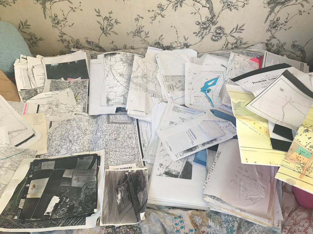
Just a small pile of the old maps, aerial photographs, documents and such like, that I have to organise, all relating to Cherry Hinton and my research.... as I find anything relating to the Tutton Way, I will add it on to this post.
If you go onto the Back Field in Cherry Hinton, at the eastern end where a passageway leads through on to Bridewell Road, you can stand on the Tutton Way as it cuts over the back field in the form of a wide paved pathway, which leads out onto Fulbourn Road. Once out onto Fulbourn Road, you will be able to see that this spot also marks the official Cambridge City Boundary, with a sign, again highlighting the importance of this ancient boundary. The back field is a Cambridge City Council owned green space which local residence use to walk their dogs and the staff, at ARM across the road, come out to have games of cricket and sit and enjoy their lunch. In the autumn there are great amounts of blackberries to be picked and in the spring the boundaries are covered in yellow daffodils. The Back Field runs from the passageway that runs into Leete Road, off of Fulbourn Road and it ends just before the hedges as you approach the roundabout at Yarrow Road, Fulbourn Road junction.
VIDEO 3 of 3 - Tutton Way
Aerial View of the Back Field on Fulbourn Road, with the Tutton Way crossing over it, on the right hand side, in the form of a pathway leading across the road and alongside the Peterhouse Technology Park, continuing up onto the Gogs
The Tutton Way can be seen in the form of an earthwork running along inside the back gardens of the houses on the eastern side of Bridewell Road. My mum used to live down the end section of this road and there was a large, clear slope running up and through her back garden which was not a natural slope but man made.
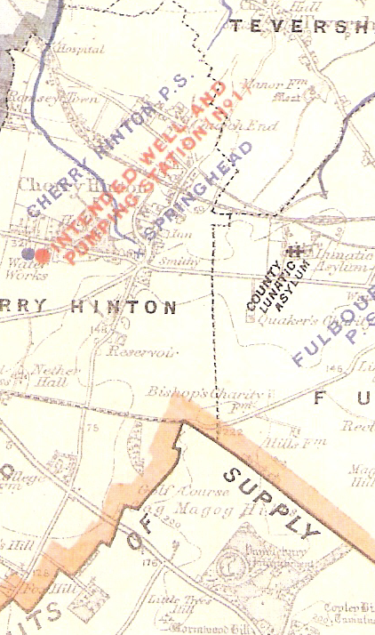
https://cherry-hinton.ccan.co.uk/content/catalogue_item/cambridge-water-works-supply-map-showing-spring-head-cherry-hinton, Cambridge Water Works c.1900
The map above (which you can see in full on the Cherry Hinton Community Archives website), shows the parish boundary marked by a dotted black line. As it stands and from what we (you and I) now know, the Tutton Way ends were it joins the old Roman Road at the end of the Shelford Gap, however, you can also see that if you were to draw a straight line from this point over the Roman Road, that the Tutton Way would lead straight into Wandlebury hill fort. I would strongly suggest that it did just that, once upon a time.
If you then follow the Tutton Way north, across the field and back towards Cherry Hinton village you come to a point where the parish boundary abruptly turns to the right, up and then to the left again, creating a off set square shape. The point at which the boundary turns is where the Tutton Way ends, as far I can tell at this time. This point is at the bottom of what is now Bridewell Road, where it meets Fisher's Lane in Cherry Hinton. The odd square actually marks out where there was once a some common land, it was called Drayton Common. It can easily be imagined that cattle were put out to pasture on the common land at this point and then driven up onto the higher ground, along the Tutton Way, perhaps in even earlier times, all the way into Wandlebury encampment itself. However, more research and on the ground field work is needed to really test out and explore if this really was the extent of the Tutton Way. It good fun to get out the maps and look on aerial views of the site and see if we can look for clues and trace the line of this old route way any further - perhaps the route continued across Drayton Common to meet at the crossroads by the church, with what is now Church Lane, the High Street and Fulbourn Old Drift? Or did the route turn at some point and join Daws Lane which runs bend Cherry Hinton Hall and was one of the old route-ways into Cambridge? etc. etc..
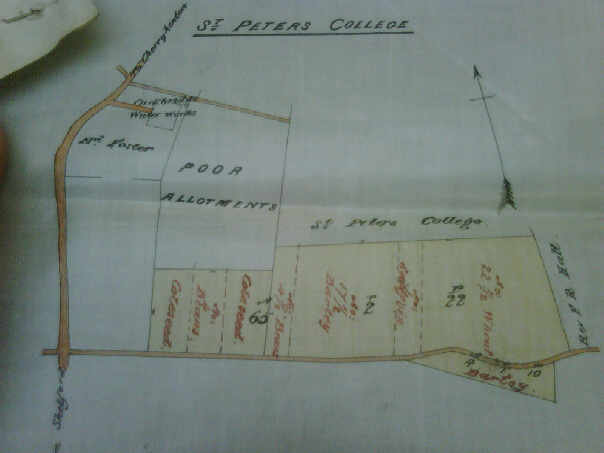
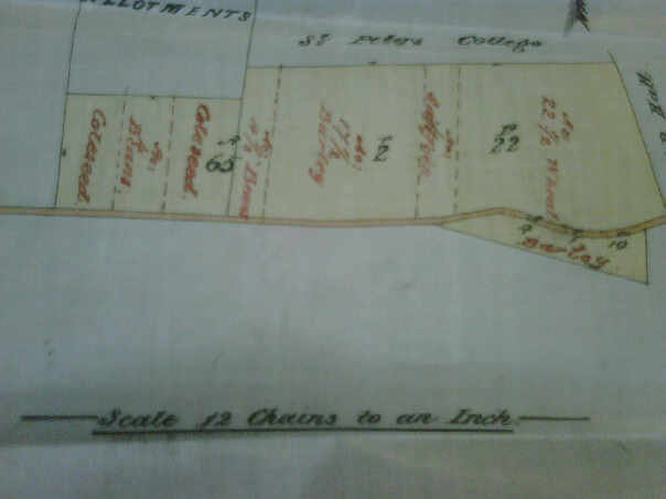
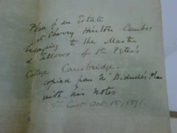
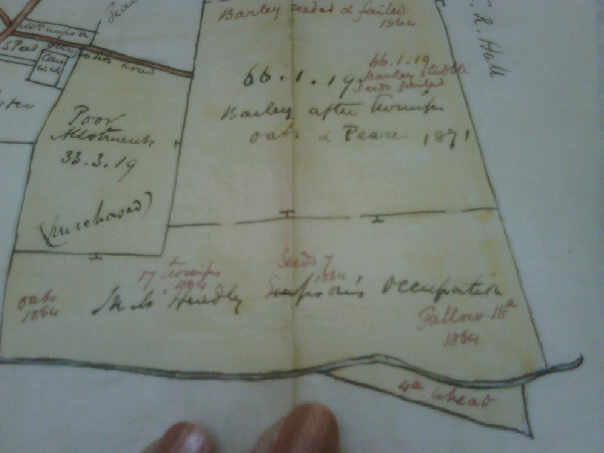
Below are a selection of photographs that I took of some of the records held by Peterhouse College, who owned a lot of land in Cherry Hinton. I am afraid that the pictures rea not very good quality as they were taken some years ago on an old phone or camera, so I must get back to Peterhouse to get clearer images. The pictures below cover the area around the Shelford Gap and are from the 1870's, recording what crops were grown and if they were successful etc. The important thing of note is that within the written columns Quarry Field is mentioned along with "Furlong abutting the Totten Way" - so the name was still in use for this route way around this date.
As always, research is never finished and theories evolve as more data becomes available but they must all start somewhere - an idea, a clue and most importantly curiosity. I will add to this and any other of my posts as and when I discover some new piece of information to add, in the meantime I hope this has been of some interest to you all :)
If you'd like to support the work that I do, why not buy me a coffee, I'd be really grateful and it will help keep me going :)
|
|||