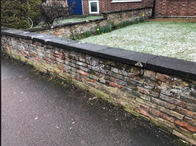
 Kenneth Price I came to Cambridge at the outbreak of the Second World War in September 1939 as a six-year-old boy, from New North Road, London, with my junior school from Islington. We walked around Cherry Hinton looking for people to take children into their houses. I ended up at a large house next to the Rosemary pub on Coldham’s Lane.  Ken as a young boy My school was in Cherry Hinton at the green tin hut near the railway crossing. After a while, my lessons were moved into the school classroom from the hut. 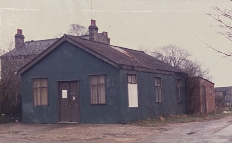 The Green Hut (Tin Hut), Cherry Hinton High Street 1987 - also used a school room, parish room, clubs, groups as well as private hire. Demolished c.2020 - (photo: R. Hoye Cambridgeshire Collection) My playground places were the Spinney in Cherry Hinton and the chalk pits at Coldham’s Lane. One night during an air raid a high explosive, bomb hit Riche’s scrap yard killing the guard dog at the nearby cement works. I was standing in the road at the time when a bomb hit the cement works but didn’t explode. 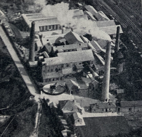 Cherry Hinton Norman Cement Works c.1955 (Blue Circle Portland Cement Booklet, Around the Works: No. 17 Norman) On another occasion, I was on Coldham’s Lane by the Rosemary pub when a German Dornier flew low over me on its way over Marshall’s airport. When America entered the war, many Americans came to Cambridge. They always had sweets to give to us children and the cement works road in Coldham’s Lane had conveys of trucks getting cement for their airfield runways. As the convoys were going into the cement works, I climbed in alongside the driver at the beginning of the cement works road, travelling with them whilst they collected the cement, and when the vehicle got back to Coldham’s Lane I got out. I always asked, “Have you got any gum chum?” They always had! When I was about nine years old, I joined the choir of Great St Mary’s Church in Cambridge, walking there and back for morning and evening services. One end of Marshall’s airfield was near to a field in Rosemary Lane. On a few occasions, my friend and I crawled through the barbed wire fencing to go up to the bombers to have a close look at them. After a few times of this, we were chased off by one of the guards, but it was good fun at the time. I spent a lot of days at Coldham’s swimming pool where I learned to swim. Coldham’s Common was covered in stone pillars to prevent German gliders or aircraft from landing. At the end of the war, I was eleven years old, and the children that I knew went back to London. When I saw my father and asked him about me going home, I was told he had no place to take me to. I then had to go to Cherry Hinton Children’s Home in Cherry Hinton Hall, with other evacuees and I attended Coleridge School. 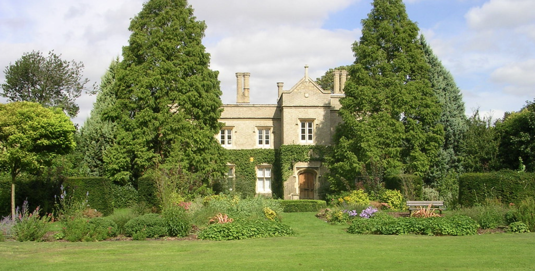 Cherry Hinton Hall c.2009 (M. Bullivant) Cherry Hinton Hall was a grand old building with a stream running underneath the building and into the lake on the grounds of the Hall. It was a good place for boys as there were plenty of trees to climb and conkers to collect. 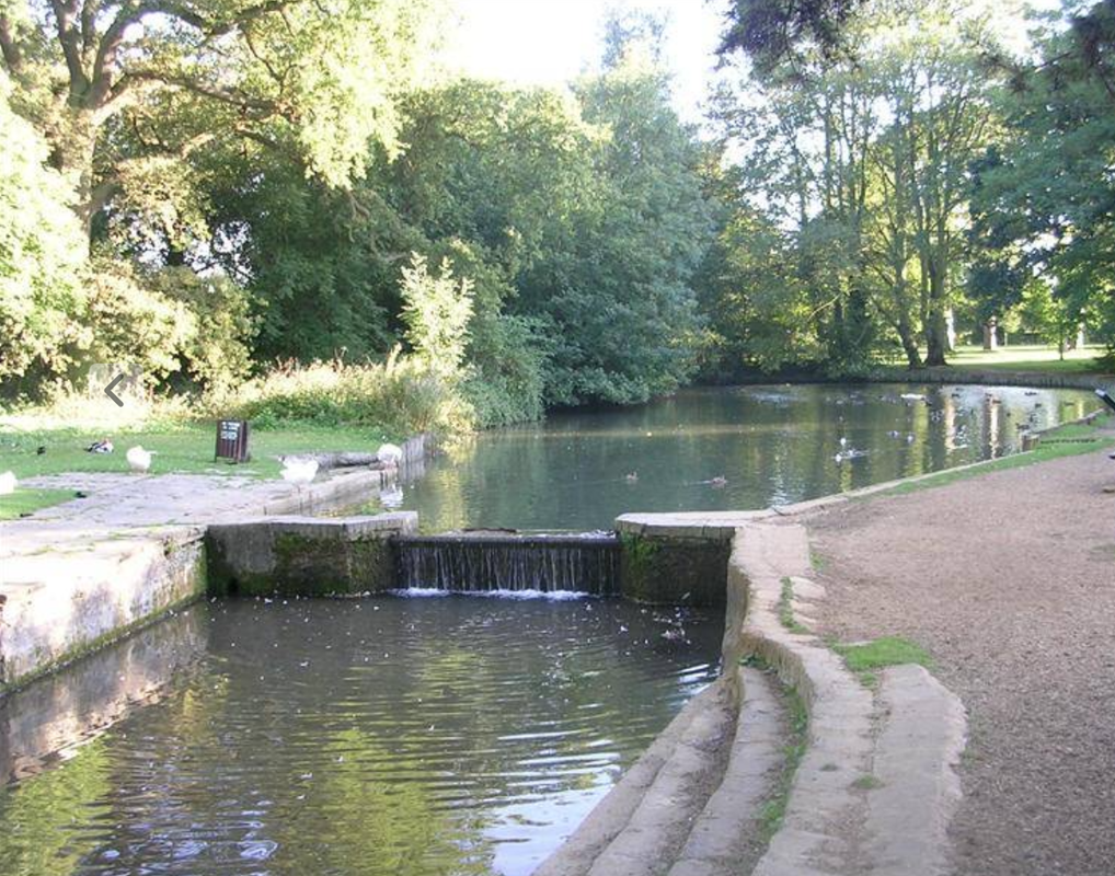 Cherry Hinton Hall duck ponds and the Hinton Brook. M Bullivant There were five other boys of various ages, and I was the oldest. It was run by Miss Johnson. She was a very good lady at running the boy’s home. She treated us as her own. It had a bad reputation owing to older streetwise boys living in the hall and the headmaster of the secondary school would come to help Miss Johnson. On Coldham’s Lane, where the sweet shop used to be opposite Queen’s Meadow, I was with a young lad who had gone into the shop to get some sweets. An older, big boy, known to be a bully came over and hit my friend for no reason at all, and made him cry. I was having none of this, so I turned round and hit him on the chin knocking one of his teeth out. Being a typical bully, he ran home crying. He got his brothers to come after me on their way to school but I used to go around other ways to avoid them and they had to make sure they were not late for school, so they never got me. The village boys didn’t realise how streetwise we London boys were. Next to the Hall was an Italian prisoner-of-war camp, on Walpole Road. I spent a lot of time in their camp talking to them as some could speak a little English and they made toys for us. After about two years of being at Cherry Hinton Hall, we were told it was going to close as a children’s home and the boys were told we would be going to the Red House children’s home at Little Shelford. This was a sad day for the boys who had nowhere else to live. On the day we left Cherry Hinton, I, being the eldest, took the boys to the pictures in Cambridge. Then we had to catch the bus to Shelford and then to the children’s home. It was a large house with many rooms and a very large garden with a brook running down one side. The bad reputation of the boys from Cherry Hinton Hall during the war had reached the children’s home in Shelford. One day, when my friend David and I were talking to two of the village girls who were on the other side of the stream, a man called out to them. “You don’t want to talk to them. They go round with a ball and chain on their feet”. So, the bad reputation of Cherry Hinton Hall during wartime had preceded us. But we changed their minds when they got to know us. I even played football for Shelford. Having moved to Shelford I still went to Coleridge School, until I left at the age of fifteen. The council then found me lodgings in Cambridge. I was then working as a printer in Cambridge. The third lodgings the council found me turned out to be two doors away from my future wife Doreen. She was fourteen at the time and I was sixteen. We were together for seventy-two years, until her death in January 2022. When I was eighteen, I was called up for the army. After several weeks of intense training, I became a paratrooper and joined Two Para serving in Egypt, Cyprus, and Transjordan. 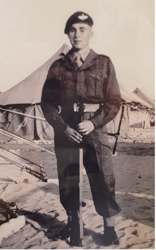 Ken at the Suez Canal 1953 When I left the army, I went back to my job as a printer. Doreen and I got married, I was twenty-two and she was twenty. We had three children, all boys. Two were twins and an older brother by three years. 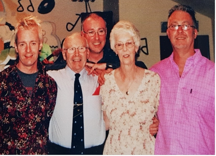 Ken, his wife Doreen and their sons. I later joined the Royal British Legion at Waterbeach and, after a few years of training, became their Standard bearer. I entered competitions and became the county Standard bearer a position I held for a number of years. It was when my wife and I went to a function on The Green at Waterbeach that I noticed there were several ex-paras there with a stall selling various items including military badges and other items of interest. They asked me if I would join the Cambridge branch of the Para Association, which I did. It was a very active branch which organized trips to Arnhem every other year. I eventually carried the branch Standard to the events at Arnhem and other places in the U.K. 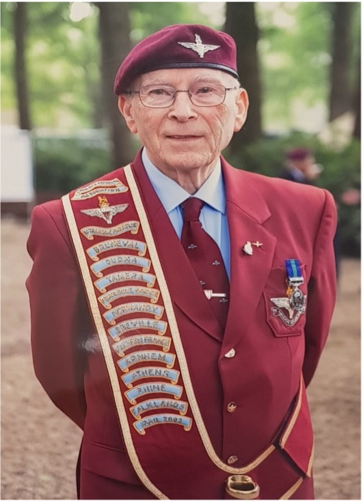 Ken in Arnhem 2013 At the age of seventy-two, I became the Para Association National Standard bearer. The Standard is the only Standard of the Para Association that has a Union Jack in the top corner. About a year later the Standard was being ‘laid up’ and I was to receive the honour of carrying the new one, at the event where it was to be dedicated at a church in Normandy. At one of the Normandy events, a bust of Major Jack Watson was to be unveiled by Prince Charles (as he was before becoming King). I asked him if he was doing the unveiling as I had the National Standard with me. He told me to bring it over and when telling my superiors of this they replied that they couldn’t overrule his wishes. 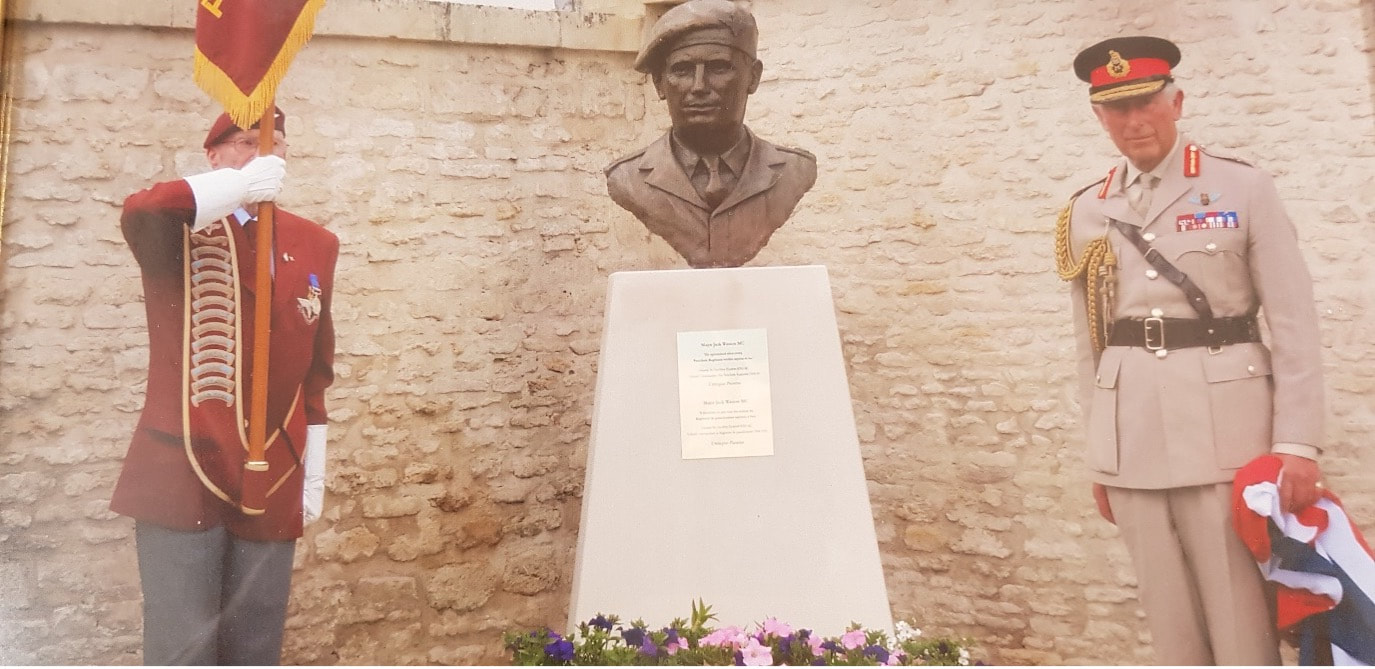 Ken with Prince Charles at the unveiling of the bust of Major Jack Watson in Normandy. In my seventeen years as the National Standard bearer, I carried the Standard every year to the Ardens, Rhine Crossing, Belgium, Normandy, and Arnhem. 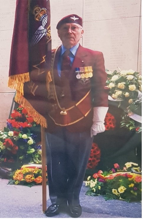 Ken at the Menin Gate, Ypres, Belgium 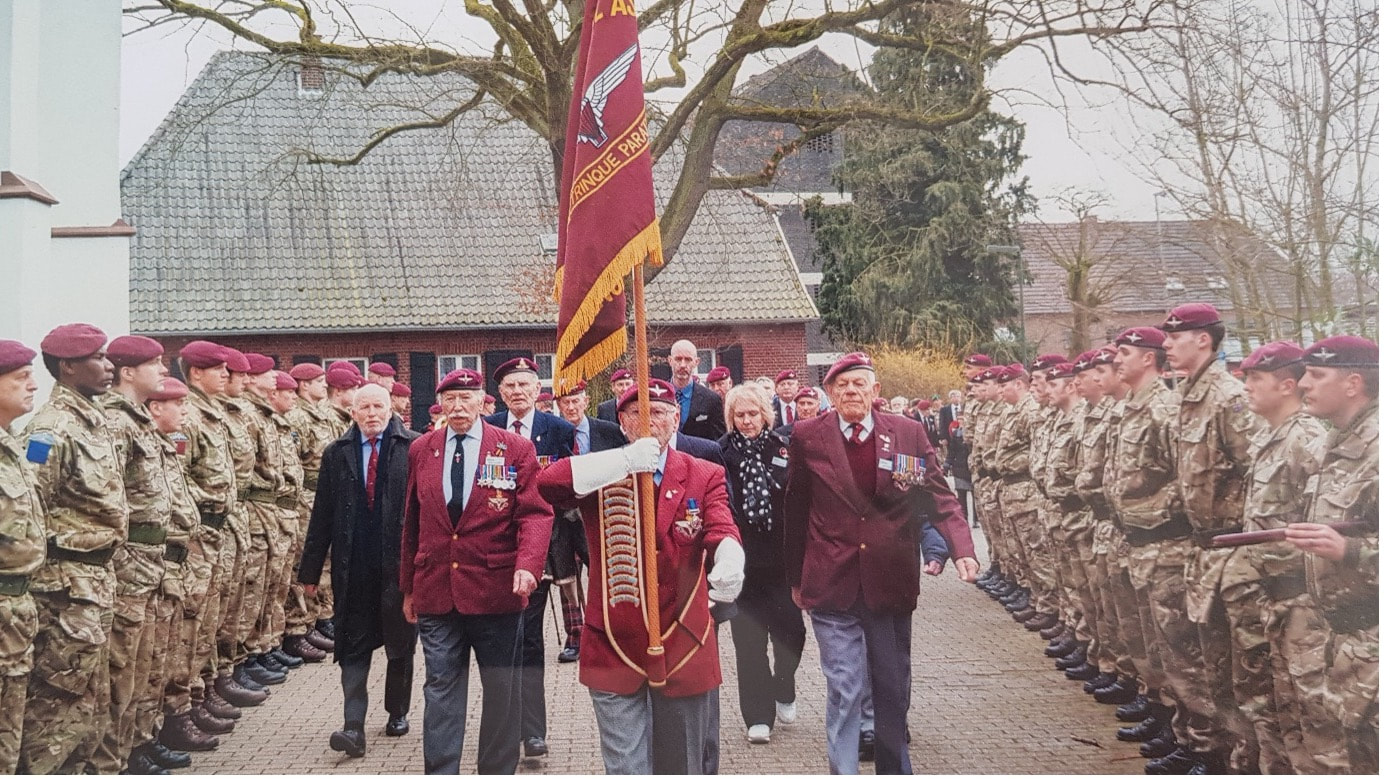 Ken Standard Bearing at Ardennes Germany I would like to pay a special tribute to my wife Doreen who accompanied me on all my duties, at home and abroad. Without her support, I am sure I would not have carried on for as long as I did. 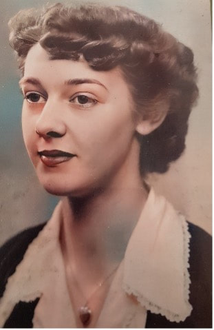 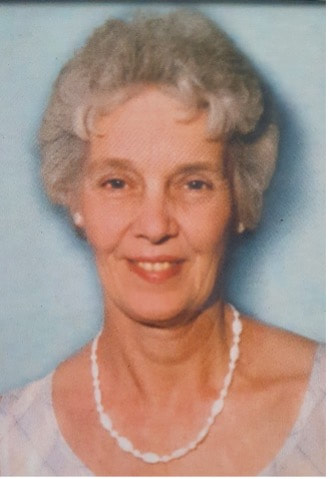 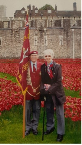 I would also like to thank the Watson family, the Zannette family whose father was a Normandy veteran, Ralph, who organised all the trips, and Barry our bugler of many years. Jane and Elaine Zannette are still very much in contact with me. I go to Kent to stay with them for a few days and they come up to stay with me. They also ring me to make sure I am okay. Ken Price 2023  Kenneth Price Many thanks to Patricia Curry for helping Ken write up his memories. You can download a PDF copy of the original article by clicking on the button below.
0 Comments
I thought that I would share with you this history of Cherry Hinton Hall, which I have been working on, for some years on and off, this latest version, given below, is based the one that I placed in the appendix of the Cherry Hinton Hall Management Plan, which I wrote for Cambridge City Council in 2019. It was used as part of the application for a Green Flag for Cherry Hinton Hall, which was a successful application with a Green Flag being awarded for the park (I will place a separate blog post about this on here shortly).
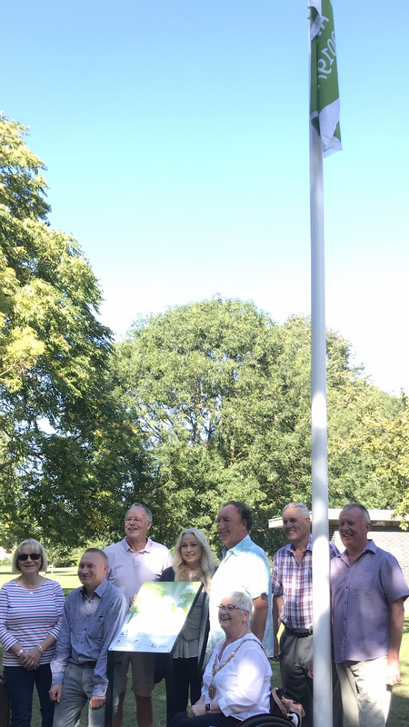
Cherry Hinton Hall getting awarded its Green Flag 2019
I am the official historian for Cherry Hinton Hall and grew up just down the road from "the Hall" as many of us called it. I went to the playgroup in the Hall building and to the clinic, again within the Hall building, for my childhood jabs. I also spent many hours playing on the park, at the duck ponds and within the grounds.
I am writing a book about the site which will give the full history, in more detail, and I will let you know when this will be available (I've been saying this for years, I know!). For now, here is a pretty decent length overview for you to have a look at.
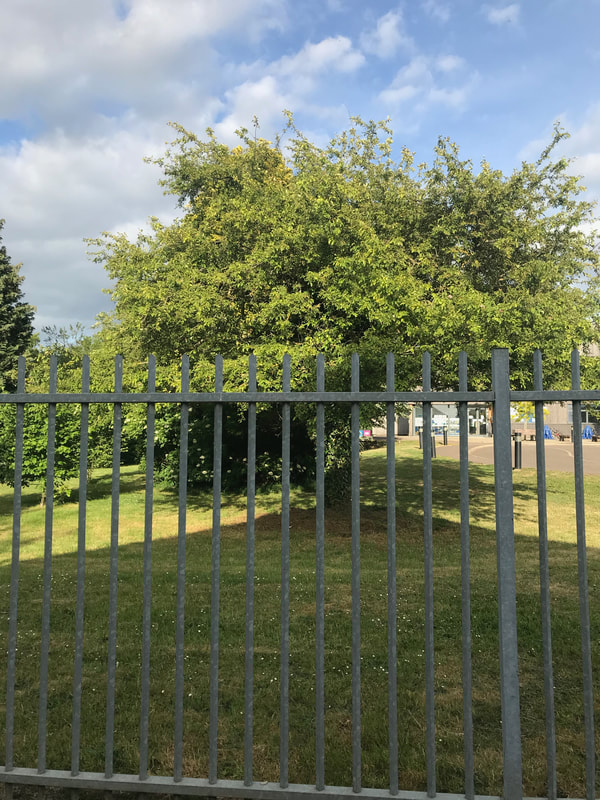
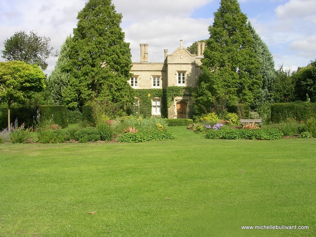
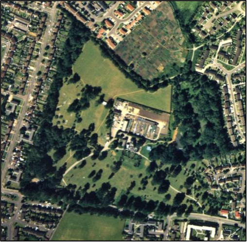
Cherry Hinton Hall is a former Victorian country house and grounds. It was built, and the grounds laid out, in the late 1830’s by John Okes, a Cambridge surgeon, as his family home. Previous to the site being developed for this use, the area it was to be built upon, was part of the medieval open field system of the village of Cherry Hinton. There are very few surviving maps of this area before 1806. We can see the pre-Enclosure map and the Parliamentary Enclosure maps of 1806. These both show the dramatic transition from the medieval open field system, upon which, the village agricultural system used to function, to the changes to agriculture and the landscape, brought about by the Parliamentary Enclosure Acts. Through which process, the opportunity was provided to wealthy investors to purchase large parcels of land, which in this case, resulted in the land for the site of Cherry Hinton Hall to be acquired. From the time the Hall and Park were constructed and laid out, the site has remained relatively intact with its transition from a Victorian, family country home to its present form, as a multifunctioning, well managed public park.
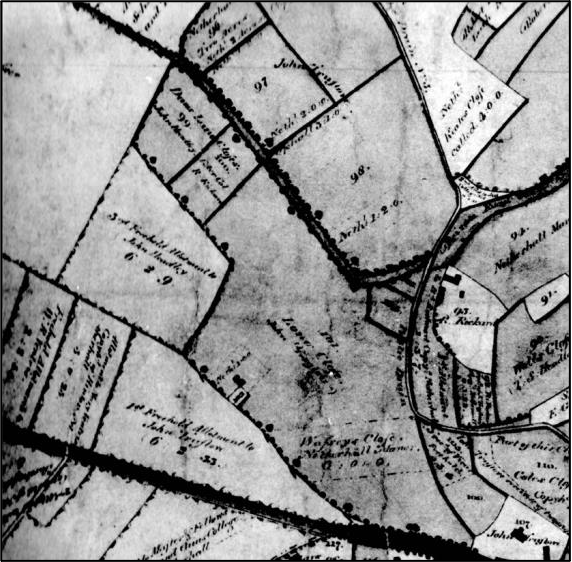
The pre-Enclosure map shows that the area in which Cherry Hinton Hall was to be built, was within one of the 6 remaining open fields of the parish, these fields formed the medieval, agricultural, open field system of the village of Cherry Hinton. The site lay within the field, to the south west of the village, called ‘Bridge Field’ and through that field, the Hinton Brook flowed from the south-eastern side of the site. From the pre-Enclosure map, we can also see that there was a building called ‘Pecks Homestead’, which would have stood just south-west of where the present-day Hall building now stands. Within the ‘lake’ area by the waterways, at the north west of the site, there once stood several other buildings, which at the time of Enclosure, were in the occupation of Robert Rickards, who was the common herdsman of the village. These buildings are thought to be that of much older buildings, likely watermills and their associated dwellings, which have stood on the site since at least the 13th century[1].
[1] Cherry Hinton Hall 2004 Historical Research & Excavation Report, Bullivant & Clarke 2004
The 1806 Pre-Enclosure map of Bridge Field, Cherry Hinton. Showing the area that was to become the site for Cherry Hinton Hall & its parks and gardens. The red dot, added, shows where the future building of the Hall would stand. The blue lines show the water course and what was to become the ‘lake’ area of Cherry Hinton Hall.
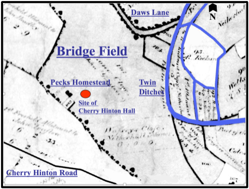
Courtesy of Cambridgeshire Archives & M.Bullivant
We can also see the waterways of the site from the pre-Enclosure map above. The square, water-enclosed island in the south west corner, may have been a medieval, moated manor site and is currently thought (M. Bullivant) to have been the site of Netherhall Manor, which was one of the 4 known but now gone, manors of Cherry Hinton[2].
[2] Cherry Hinton Hall 2004 Historical Research & Excavation Report, Bullivant & Clarke 2004
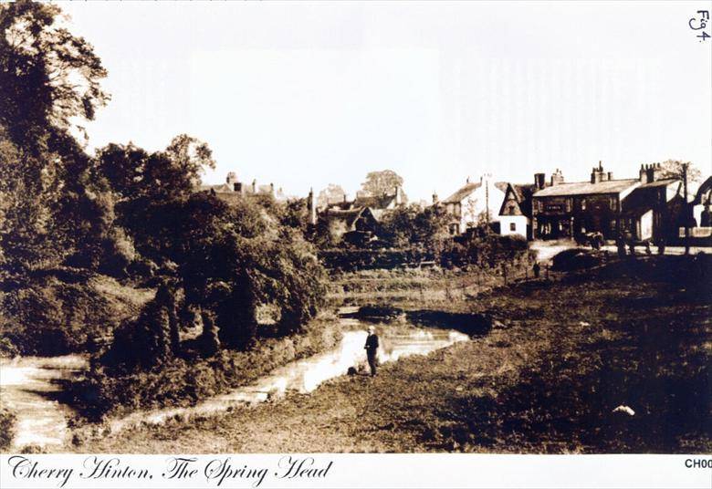
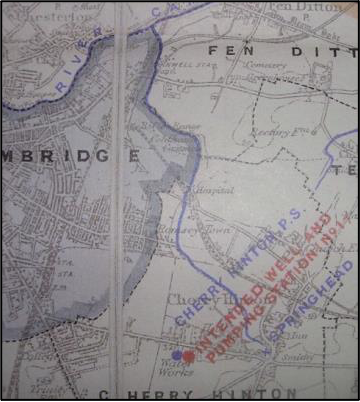
The Hinton Brook, which runs through the site, was an important tributary of the River Cam, where it joined its destination at Stourbridge Common in Cambridge. The Brook broke forth as a series of fresh water springs at the north-west base of the Gog Magog Hills and formed a spring pool, known locally as Spring Head (also known as Giant’s Grave). The Spring Head was no doubt a major factor in the siting of the village. From the Spring Head, the chalk lined, fresh water brook, flowed in a north-westerly direction, where it entered Bridge Field, to be manipulated for early industrial purpose, before flowing on north-westerly to eventually join the River Cam.
Courtesy Cambridgeshire Collection
Cherry Hinton Spring Head (aka Giants Grave) c.1910
Once the Parliamentary Enclosure had taken place, in 1806 in Cherry Hinton, much of the land ownership and use changed dramatically. The old, large, open fields and those systems of agriculture were gone. The land was divided up and sold into smaller parcels and new owners took over. Robert Rickards, the common herdsman living in Bridge Field, for example, was given notice to quit the property and land in 1814 and had to leave his home. These changes ultimately led to the purchasing of the land in Bridge Field and surrounding parcels of land by Mr John Okes, who planned and executed the building of Cherry Hinton Hall and the layout of its grounds. This new development work included clearing the old buildings that stood within the lake area of the site and once occupied by Robert Rickards and clearing the site of Pecks Homestead, all in preparation for the building of the Hall and park design, which began in 1831.
Courtesy of Cambridgeshire Archives.
The 1806 Enclosure map of Cherry Hinton, showing what was Bridge Field.
John Okes had returned from the army in India and joined his father, Thomas Verny Okes, a well-known surgeon, at Addenbrooke’s Hospital, to work as a surgeon at the hospital himself. At this time Addenbrooke’s Hospital was on the Trumpington Road site, within the town of Cambridge. Cherry Hinton Hall was completed by 1839 and John Okes had laid out his ‘miniature park and gardens’ around the Hall building. The site was just 3 miles from the Cambridge town and the Old Addenbrooke’s Hospital. It provided a perfect family home for John, his wife Mary and their children, an escape from the busy town, which lay just within the bounds of the countryside.
Courtesy M Bullivant
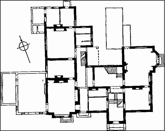
Plan of Cherry Hinton Hall c.1960 , shows the various additions (shown in light tone) to the original form (shown in heavy tone). The additions include the billiard room to the north-west side and various minor additions to the rear. You will see that there was once a staircase added, within the main entrance porch, which is no longer there today.
Cherry Hinton Hall was built in the Gothic Revival style. It was placed centrally within the grounds. Built in Gault brick with stone dressing, with stone and slate covered roofs. The chimneystacks have separate octagonal shafts with oversailing brick capping. The glazing was lead-traced lozenge-shaped panes. The coach-house and stables were built just to the north west of the main building and the small Lodge was built in the same style as the house, to the south-west of the main Hall building, by the entrance gates and entrance to the driveway. The Lodge originally had its own length of garden, which ran to the eastern side of the property. The park and gardens were laid out with meadow and pasture, along with formal garden areas at the very front of the building, a kitchen garden to the rear of the property and features such as the orchard that lay within the lake area upon the place where Robert Rickards had once lived.
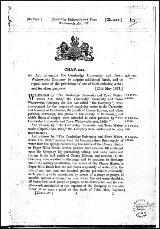
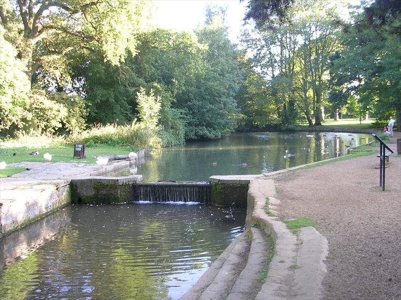
John Okes had the water course, flowing through his land, enlarged at one point to make an small ornamental lake and stocked the stream with trout and had a pike pond made. He also spent a considerable amount of money in planting the grounds. He had four weirs built along the watercourse to help control the water and a special deal was agreed with Cambridge University and Town Waterworks Company (CUTWC), of which John Okes’ brother Richard Okes was a Director, to supply a specific gallonage of water to the lake and stream at Cherry Hinton Hall, as the CUTWC had also acquired land in Cherry Hinton, specifically bought to begin taking advantage of the natural spring water that flowed out the chalk hills just to the south-east. This eventually resulted in the action of building reservoirs on top of Lime Kiln Hill, close by Cherry Hinton Hall and would have a drastic effect on the flow of water into the site, so specific plans were made and the design and control of the waterway running through the hall was managed in order to please both parties.
Courtesy of the Cambridgeshire Collection
Front-piece of the Cambridge University and Town Waterworks Act 1871.
Courtesy of the Cambridge Water Company
Cambridge University and Town Waterworks Company waterworks map.
© M. Bullivant
The lake area of Cherry Hinton Hall (the duck pond and early paddling area) showing the Hinton Brook flowing through towards us, and showing one of the four weirs that John Okes had built during the Victorian period.
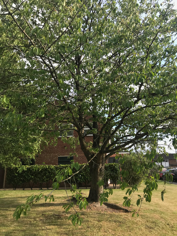
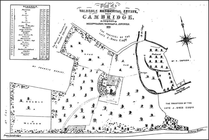
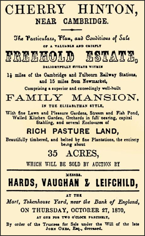
The planting of the varied selection of important trees adds to the historical value of the park. A combination of natural countrified meadows and paddocks with a mixture of formal gardens. From the sale particulars of the site in 1870, it can be seen that the grounds included a loose avenue from the gate lodge to the Hall, with the driveway forming a turning area on the Hall’s south side, outside of the front door entrance. Other parkland features included a kitchen garden, lawn and flower parterres, shrubberies and a fernery, two orchards, ornamental pleasure grounds, park-like paddocks, stream and fish pond, fine lawn, beautifully timbered and belted by fine plantations all set within about 35 acres.
John Okes died in 1870 and Cherry Hinton Hall and grounds were placed on the market for sale. The layout of the site, as he had intended it, can be seen from the sale map and particulars of the site. The sweeping driveway which ran from the south west of the site and curved round to the north east to meet at the front door of the hall was laid out when the grounds were planned, and remains, in its original position to this day.
Courtesy of the Cambridgeshire Collection
Cherry Hinton Hall sale map, 1870. This map shows the detail of the grounds and features therein.
Courtesy of the Cambridgeshire Collection
The sale advert for Cherry Hinton Hall 1870.
Following the death of John Okes, the site was sold to Cambridge University and Town Waterworks Company (CUTWC) for the sum of £5000, who went on rent the property and its grounds to private tenants. Cherry Hinton Hall remained in private occupation for around the next 60 years. During this time various people lived at the Hall.
The first tenant after the death of John Okes was Charles Balls. Charles Balls had started out life working as a shoemaker and then went on to become a Mayor of Cambridge and later a Director of The Cambridge University & Town Waterworks Company. He, his wife and four of his daughters lived at the Hall. His wife Eliza died in 1876 and Charles and his daughters remained at the Hall until 1888, when they moved back into Cambridge Town Centre.
Courtesy Cambridge City Council
Charles Balls (1810-1892) Read more here:
https://www.findagrave.com/memorial/181126309/charles-balls#source 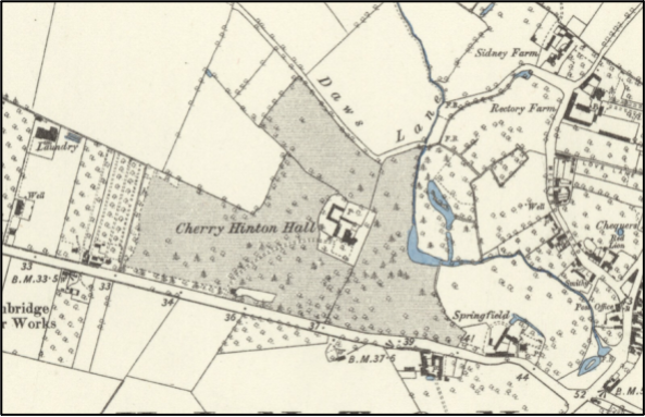
O.S map of 1886
The O.S map of 1886 shows the park with its water ways, planting, buildings and curved driveway. At this time, the Lodge can be seen with its plot of garden running to the east of the Lodge building.
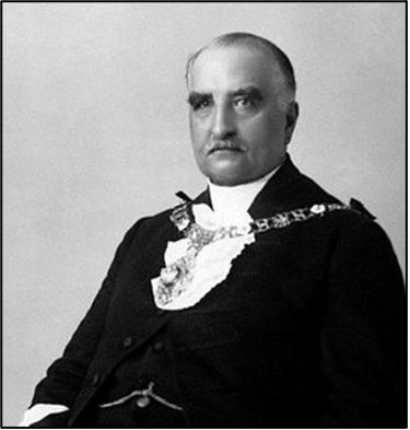
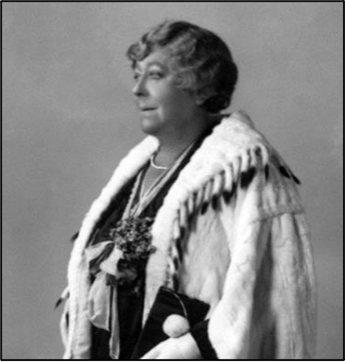
Robert Moffatt, a General manager of a bank in Cambridge, and his family lived at the Hall for a few years until Major Richard Thomas Lyons, a retired military surgeon, took over the tenancy for another couple of years until c.1900. Cherry Hinton Hall was then unoccupied for a short while until 1902 when Sir William Phene Neal and his wife moved in.
Sir William Phene Neal and his wife, Lady Eleanor Vise c.1902
Sir William Phene Neal who lived with his wife, Lady Eleanor Vise, at Cherry Hinton Hall, created the Cherry Hinton Hall Dairy Farm within the grounds. He went on to become the Lord Mayor of London in 1930 and local stories tell of remembering him being driven in a beautiful horse drawn carriage down the drive, from the park grounds and onwards to Cambridge train station, where he would travel to and from London. Last occupier of the Hall before its sale in the 1930’s was Lt. Col. Brocklehurst Phillips O.B.E.
Cherry Hinton Hall in 1910, showing the drive return and front garden planting.
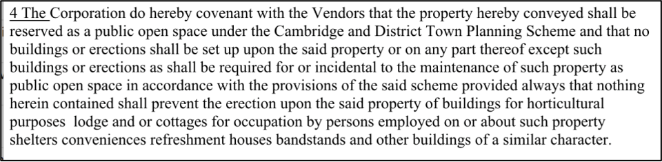
Ownership remained with The CUTWC and as such the Cambridge University Trinity Estates to which CUTWC was held, until 1937 when Cambridge City Council purchased the whole site, Hall and grounds and the site remains in their ownership today. This particular period was one where nationally the move to acquire and ornament public open spaces was prevalent. Cambridge City Council purchased the Hall and the grounds in May 1937, for £13000.00, and it remains in their ownership today. In November 1937, a conveyance document with covenant was drawn up which laid out the conditions of the purchase. The covenant stated that the site “shall be reserved as a public open space under the Cambridge and District Planning Scheme”.
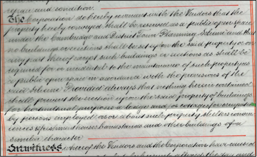
Original Deed of covenant, 1937 and Below: The transcription of this section
Some of the parkland was lost in the sale of the site to Cambridge City Council. A large portion, to the west of the site, was sold off to a Mr Ridgeon (now a well-known Cambridge building firm, Rigeons) and subsequently houses were built along this strip, along with the creation of a new road called Walpole Road.
Cherry Hinton Hall c.1930 OS map, showing the planning position for Walpole Road, across the western side of the grounds. Note the Lodge garden is gone by this date and the driveway finishes at the Hall in a circular sweep.
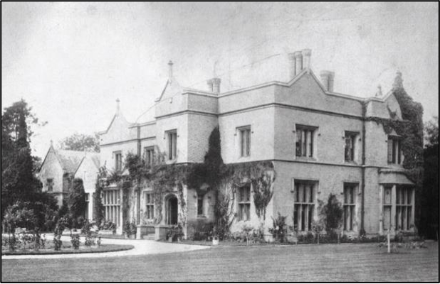
For the first couple of years in the Councils ownership Cherry Hinton Hall becomes a Youth Hostel. With the outbreak of WWII, the Hall was used a fire depot and a training centre. It then became a home for young evacuees from London.
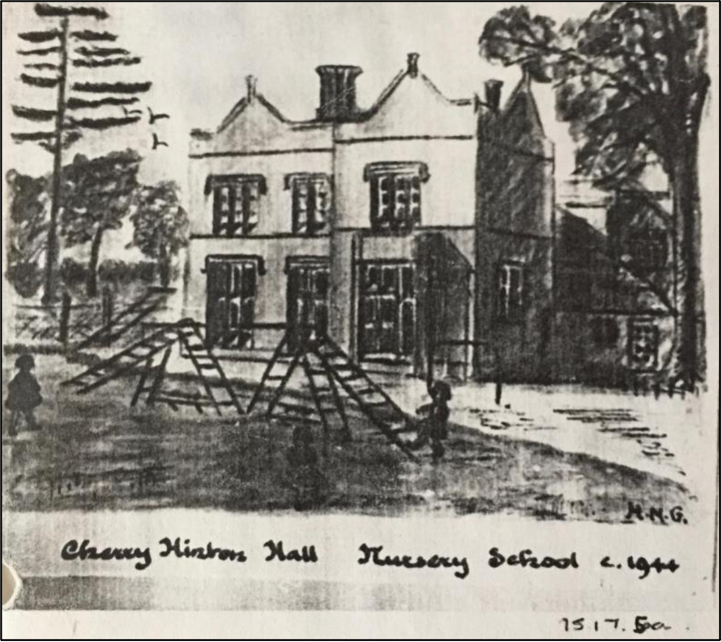
After Second World War Cherry Hinton Hall was used as an orphanage and by 1944 the Hall was host to a nursery school from 1944-1988.
Courtesy Cambridgeshire Collection
The Inventory of the Historical Monuments in the City of Cambridge, originally published by HMSO in 1959 contains the following entry for the Hall:
“Cherry Hinton Hall, nearly 3⁄4 m. S.W. of the parish church, of two storeys with cellars, has gault brick walls with stone dressings and slate-covered roofs. It was built for John Okes and the title to the property begins with the purchase of plots of land in 1834 (University Library, Map Room: sale advertisement, 1870). Scratched on the roof-lead is the date 1839, to which the house would approximate on stylistic grounds. Late in the same century a billiard room was added on the W. Since 1948 it has been converted into a day-nursery and clinic involving alterations and additions inside and out. The coach-house and stabling standing nearby to the N.W. have been drastically remodelled to provide living-quarters. The Lodge some 210 yds. to the S.W. is contemporary with the house. Cherry Hinton Hall is a large and rather bald building of the first half of the 19th century in the late Tudor style. The elevations generally have moulded strings at first-floor sill and eaves levels, tall parapet- walls carried up in gablets with moulded copings and apex-finials and stone-mullioned windows of one, two and three square-headed lights with labels; the ground-floor windows are transomed. The S. front is asymmetrical on plan and in height, the porch and the E. part being slightly higher than the rest westward. The doorway has continuously moulded jambs and four-centred head. The rectangular bay-window towards the W. end is an early addition. On the N. side is a four-light transomed window lighting the original staircase; to the kitchen is another of five lights on the W. side. The lights in several windows have been cut down for doorways and french-windows, others retain the original glazing of lozenge-shaped quarries. The chimneystacks have separate octagonal shafts with oversailing brick cappings. Inside, the staircase in the entrance-hall is a modern insertion involving the blocking of the four- centred archways in the N. and W. walls. The principal rooms have doorways with architraves and six-panel doors all with roll-mouldings; another period allusion is the heavy moulding of the plaster cornices. The E. part of the house retains two original fireplace surrounds of gray polished stone, with moulded jambs and four- centred arches, sunk spandrels and moulded shelves; they are flanked, one by pilaster-like responds with roll-moulded angles and moulded caps, the other by octagonal projections with trefoil-headed sunk panels in the faces. The main staircase has close moulded strings, grip handrails, square panelled newels and pierced strap work balustrading of gilded woodwork. The back staircase has cut strings, a turned newel and slender square balusters. The Lodge, of one storey, with gault brick walls with stone dressings and tile-covered roofs, of uniform character with the house, has been much enlarged. It has large gables, and a smaller gable to the porch, all with moulded stone copings rising from corbelled kneelers. The windows have stone mullions and the tall chimney-stacks octagonal shafts.”
The grounds of the Hall were opened up to the general public as a public park in 1960. The Lodge building was rented out to a park steward who was responsible for opening and closing the gates and other duties (the park ceased to have a steward by the 1990’s and the lodge building continues to be rented out privately by the City Council.) Before long, there was the addition of a car park to the south west corner of the site, just inside of the front gates, along with the addition of a public convenience. This public park development of the site included providing a healthily stocked duck pond and a bird sanctuary to the eastern area of the site within the waterways. The paddocks at the north-west of the site were turned into a games field and the site began to take shape in its new role for the pleasure of the public. This development also, in turn, enabled protection and preservation of the wide variety of mature parkland trees and features.
Within the Hall building the children’s nursey continued, and there was a health clinic and offices from the 1960’s until the 1980’s.
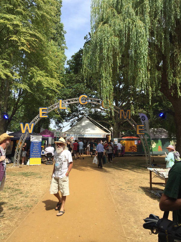
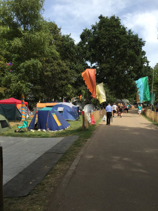
In 1965 the first Cambridge Folk Festival was held, set within the grounds of Cherry Hinton Hall. The Folk Festival has been held annually, at the site, at the start of August, ever since and celebrated its 50th anniversary in 2014. It has grown to become one of the premier music events in Europe and one of the longest running and most famous folk festivals in the world. As a result, Cherry Hinton Hall is known world-wide and loved by many thousands of people, who over the years have attended the site.
By the mid 1970’s a paddling area was provided within the Hinton Brook, just north of the duck pond and a play area, with playpark equipment, was in use to the west of the site, where the playpark area has remained since.
c. 1979, Playpark equipment in the Hall grounds, close to where the present-day playpark is now situated. The photographs show a see-saw, a roundabout and a climbing frame. You can also see a bench, showing that public park furniture was being provided by this time (©M.Bullivant)
During this time Cambridge City Council continued to use the Hall building for office space and the rear of building was used for the City Council’s storage and horticultural use, for which they built glasshouses and a developed a nursey/propagation centre to provide bedding plants for council planning schemes.
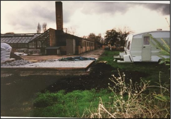
c.1995 - The council propagation centre and planting nursey (now demolished) at back in the Hall building, which would have once been the site of the Victorian kitchen garden. (©M.Bullivant)
By the 1980’s the site was in full use as a public park and had developed a reputation of a lovely place to visit. There were regular outdoor performances by brass bands and families used the site for picnics. Cherry Hinton Hall became a firm favourite with dog walkers and duck feeders across the city and beyond. By 1988 the Hall building was then rented by the council to Eastern Arts, an arts development company, who additionally provided some art for the grounds of the Hall for the public to enjoy. There was also a fenced-off special bird sanctuary, to the east of the site, on the island beyond the lake and more wildfowl were introduced to the site.
c. 1984, Playpark equipment in the Hall grounds, close to where the present-day playpark is now situated. The photographs show a new roundabout and ‘rocking’ horses. (©M.Bullivant)
In 1987, a refreshment kiosk was opened on the west side of the building, this was only in service for a short time.
Aerial Photograph of Cherry Hinton Hall 1987 showing the site. (Courtesy of Cambridge University Committee for Aerial Photography).
During the 1990’s the playpark was further refurbished, with distinct toddler play areas and older children areas. A major new paddling pool area was constructed, which consists of two pools, one for general use and one for toddlers.
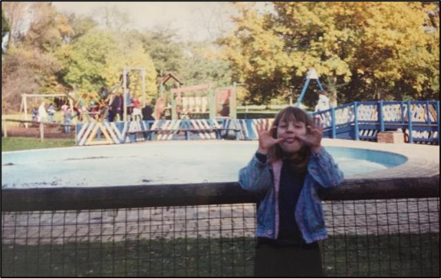
The newly built paddling pool, c.1995 with playpark in the background. (© M.Bullivant)
This wall was one of two original entrance walls, either side of the front door to the Hall building. This western wall, shown, was removed in the late 1990’s to make adaptions, in the form of a sloped pathway, so that the hall was wheelchair accessible, as previously, at the front of the entrance walls, were several steps. (© M.Bullivant)
In the 2000’s, tennis courts were added to the site, just immediate north to the playpark area and exercise equipment was also added. The bird sanctuary had closed by this time and some tree art was made from trees that had been retired. Further play area improvements were made with the addition of an accessible, disabled play equipment.
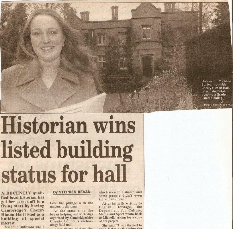
When I first started my research into the history of the Hall, back in 1998, I was amazed to learn that the buildings were not even grade listed. So I set about finding out how one goes about such a thing and I was successful in getting the Hall and buildings listed. If I can do it, so can you - always have a check if you think a building should be listed and now a days you can do the whole process online. I know it can be a mixed bag in some respects because of restrictions that then get placed on a building but I really did think it worth getting the Hall listed, to protect it for us all as it is a public park and we locals love it.
Courtesy Cambridge Evening News
Cherry Hinton Hall is a Grade II listed building and was added to the Statutory List on 19 September 2002, along with the Lodge, gate piers and the gates at the drive entrance. The list description is provided below:
“667/0/10138 Cherry Hinton Hall 19-SEP-02 Grade II
Small country house, now training centre. 1839. For John Okes. Gault brick with stone dressings and parapeted slate roofs. Ornamental brick stacks, some with multiple flues. Tudor style with coped gables with finials. 2 storeys, attic and cellar. Entrance front is a 6-window range in all at first floor of 2-light casements with hood-moulds (single-light 2nd from left). To centre right is a projecting gable with a panelled door with Tudor-arched surround and casements to side walls and over. On the front to both sides of this projection are 2-light stone mullion and transom windows, one to right and two to left, some with leaded lights. On far left a gabled projection with large square bay to ground floor. Two gabled ranges further to left, one single-storey, the other 2- storey. Front to right has 2- and 3-light casements over taller similar mullion and transom windows with a canted bay to right. Rear has various wings and C20 extensions. A large leaded mullion and transom window lights the main staircase. INTERIOR. Entrance hall has arched screen and carved stone fireplace. Staircase hall has open well staircase with pierced fretwork balustrade. Other reception rooms have similar stone and marble fireplaces. Simpler fireplaces on first floor. Cornices and panelled reveals in some rooms. Service stairs with stick balustrade. Service wings have mainly C20 character. Cherry Hinton Hall is a well-detailed house of the period which retains many exterior and interior features. It forms a group with The Lodge and gate piers and gates at the drive entrance.”
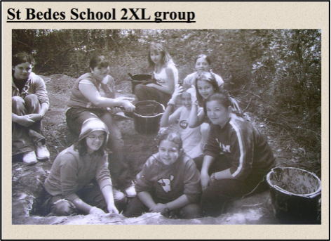
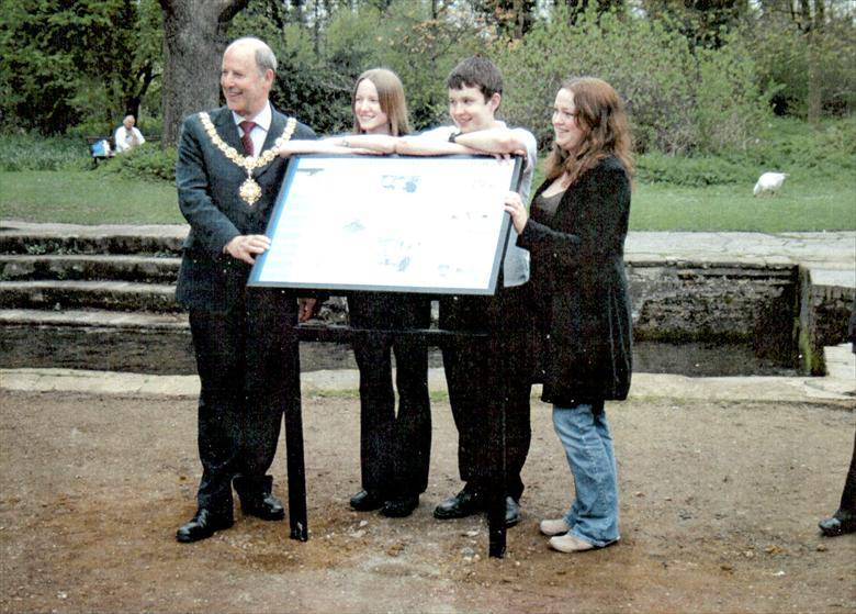
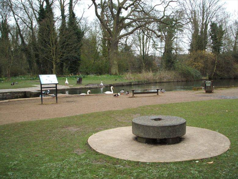
In 2004 I ran a community archaeological investigation. A 'dig' around a small area of the site was carried out, within the lake are in order to establish the whereabouts of a lost medieval watermill site. The work was designed to include participation from the children of one of the local secondary schools and the end result was 2 different interpretation boards for the park along with public information leaflets, a better understanding of some of the archaeological history of the site and the discovery of one of the original medieval mill stones, who now makes an unusual seating feature by the Hinton Brook and information board. The site, as a whole, remains rich in archaeological remains and potential for future excavation and investigation.
I will do a separate blog post on here about this - 'The Lost Watermills of Cherry Hinton"
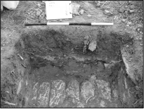
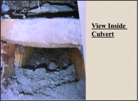
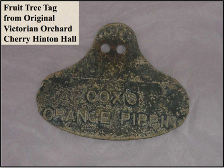
Photographs from the 2004 excavations at the Cherry Hinton Hall, Lost Watermills Excavation. Top Left: Children getting hands-on experience. Top Right: Capping stones of an old culvert discovered. Middle Left: View inside the culvert, which proved to be from the medieval watermill workings. Middle Right: A Victorian metal fruit tree tag, from John Okes’ orchards.
Bottom left, unveiling of the new information board by the lakes, about the findings and the lost watermills of Cherry Hinton. Bottom right, the new board by the lakes and the original medieval mill stone that I found on site during the project, now placed as a seat for all to enjoy. (© M.Bullivant)
After the departure of Eastern Arts, the Hall building has been leased to The Cambridge International School, since 2008, who remain the tenant of the building today. The school have just completed a major redesign and refurbishment of the main Hall buildings, at their own expense, including the building of a new all-purpose Hall, named The Okes Hall, at the rear of the main Hall. The Council continues to use an enclosed area to the rear of the main Hall building for storage and other council use, including a service area for when the annual Cambridge Folk Festival takes place.
With the design of the Master Plan for Cherry Hinton Hall in 2009 by Cambridge City Council and its subsequent implementation over the last 9 years, along with the formation of The Friends of Cherry Hinton Hall in 2009, it is clear that people still care and are passionate about this special place and that whilst utilising the site, it should be preserved and protected.
In the 21st century, the park remains an important amenity for visitors, students, and local residents, being an important green space between Cambridge town and Cherry Hinton, giving the village of Cherry Hinton some much needed distinction and preventing it being swallowed up to become an indistinct suburb of Cambridge City, whilst at the same time being within easy reach of the City and Cambridge Train station. The park is also in close proximity to Addenbrooke’s Hospital, a major employer in Cambridge providing, not just green relief for the staff, but also the visitors to the hospital. In addition, the Cambridge Silicon Valley and technology park is only a few minutes’ walk away from the park, the site proving a popular lunchtime space for its workers. The proximity of several schools to the site means that the grounds are put to good use for educational purposes and the site remains an important tool, for positive development of future generations.
So, there you go, that hopefully gives you a good general feel for the main points in the growth and development of the site and a bit more about its history. I have no-end to add to this which I have already written down, from much more detail about John Okes, who built the Hall and his family, to more in-depth details of happenings at the Hall and grounds over the years, including many written memories from many people, old photographs and voice recordings. I will bring you all these in due course :)
If you'd like to support the work that I do, why not buy me a virtual coffee, I'd be really grateful and it will help keep me going! Just click on the green button below :) 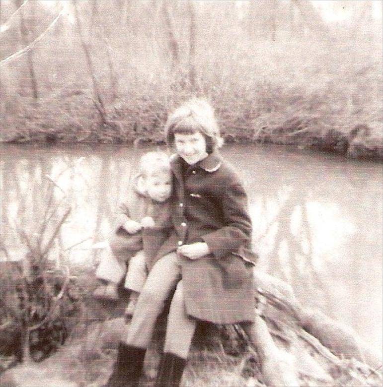 This is my mum Elizabeth Toller-Brown with her nephew, my cousin, Christopher Brown, siting on a log by the Hinton Brook in the grounds of Cherry Hinton Hall c.1960.
Courtesy of Cambridge University Library Spring Head is the natural spring pool that breaks forth at the base of the Gog Magog Hills. It was one of the original reasons for the siting of the village of Cherry Hinton and is still, today, the village pond. Spring Head is also known locally as Giant's Grave and there are still superstitions about the site, which are closely connected to the tales of giants once living in the area and on the Gog Magog Hills. Spring Head feeds the Hinton Brook which flows on through Cherry Hinton and Cambridge to join with the river Cam.
 This is a picture of one of the weirs at Cherry Hinton Hall. There are four weirs within the water course, which is know as Hinton Brook. Hinton Brook flows from Spring Head at the Robin Hood Junction on the High Street of Cherry Hinton.
The weirs were put in place in the mid 1800's by John Okes, in conjunction with Cambridge University and Town Water Works Company, to help the flow of water through the grounds of the newly built Cherry Hinton Hall. John Okes was a surgeon at Addenbrookes Hospital and had Cherry Hinton Hall built in 1835.
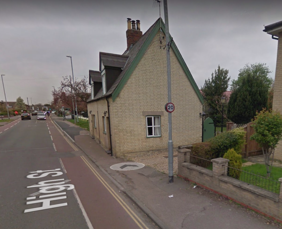
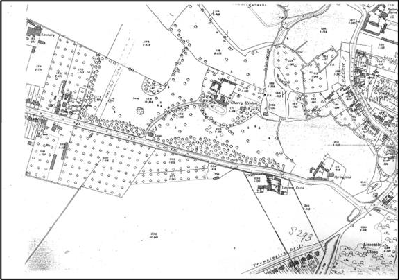
Lime Tree Farm stood on the northern side of Cherry Hinton Road, more or less opposite where the Army Reserve Centre and BP garage are today, on the other side of the road, a little to the west of Cherry Hinton Hall. The Coe family lived there for over a hundred years, originally market gardeners, growing produce on the surrounding land and fields, by the 1950's a tea room and small shop had opened at the farmhouse run by Mrs Elsie Coe, eventually becoming a small independent shop run by her daughter-in-law Mrs Eileen Coe in the 1980's, after the market gardening had ceased. In the 1990's Mr Cyril Coe and Mrs Eileen Coe sold off the remaining farm surrounding the main house, where the modern Coe's Court was built. They then had a bungalow built on the site, facing Cherry Hinton Road, for themselves - the old house eventually being demolished, as the new development continued. Mr Cyril Coe died in 2006 and Mrs Eileen Coe died in 2009. This ended the Coe family line at the site of the what was Lime Tree Farm. The old pollarded lime trees along the front of the site still remain today, and many people who have lived in the area still remember visiting the little shop that was once so popular.
Location:
Lime Tree Farm was on the northern side of Cherry Hinton Road, to the west of Cherry Hinton Hall, laying outside of the built area of Cherry Hinton village. It lay at the southern aspect of Cherry Hinton, in the Mill End area.
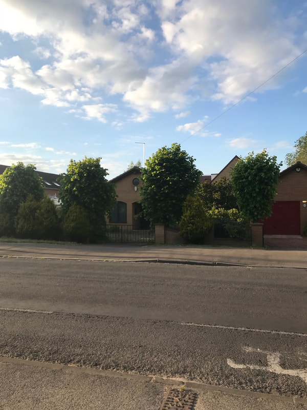
How the site, of what was Lime Tree Farm, looks today, from Cherry Hinton Road. Pollarded Lime trees still line the front boundary.
We can look at what we know of this area, before Lime Tree Farm came in to existence but it would seem that we are looking at the creating of the site as a farm being in the mid 1800’s.
Before Enclosure took place in Cherry Hinton, in 1806 - which ended the old, medieval open field system and divided the land up into different parcels and shapes, with new landowners coming in, some roads altered and new ones laid out - the site where Lime Tree Farm stood would have been quite marshy here and there, as it lay on the lower, flat land, which until the mid-late 1800’s was not fully drained. It is unlikely that there was anything built on this site before Enclosure. Within the open field system, the site lay within one of the large open fields of Cherry Hinton, called Bridge Field. From the two older surveys that we have of the parish, prior to Enclosure there is no mention of a farm within Bridge Field. (Saxton survey 1592 & Tracey survey 1733). As is the case with the pre- Enclosure and Enclosure maps c.1806, there is no noting of any building upon the plot that was later to become Lime Tree Farm.
It is likely, that with the opportunities presented by the new divisions and alterations of the land around the parish, when Enclosure took place in 1806, that the land required for the farm was purchased and arranged around that time. Then, with all the new improvements, including the laying out of public drains and roadways, it gave the perfect situation for a new building site and positioning of a farm. Cherry Hinton Road had not existed before Enclosure - instead there was a route, slightly off course of the modern road now, called Long Drove, that only ran a short way from the Robin Hood crossroads into what are now the grounds of Cherry Hinton Hall, presumably because the fields beyond, towards Cambridge (Hill’s Road), were so prone to flooding. As we can see by what Vancouver wrote about this area of Cherry Hinton in 1794:
‘There is a moor of considerable extent lying between the highlands of Cherry Hinton and Barnwell on the north east and at Trumpington and Cambridge on the south west, which at this time is greatly annoyed by the stream which passes through the west end of Cherry Hinton. This moor is sacrificed to the constant height of water in this brook.’ At Enclosure, a plough was employed to drive a straight furrow all the way along from Fulbourn to what is now Hills Road, to create Cambridge Road - now called, Cherry Hinton Road. The main routes in to Cambridge, pre 1806, were over Lime Kiln Kiln to the Three Hills Way (that led into what is now known as Hills Road and then on into Cambridge) or down Daws Lane, an ancient route-way, now a footpath, laying behind Cherry Hinton Hall, along with other seasonal footpaths and route-ways that traversed through the centre and north of Cherry Hinton.
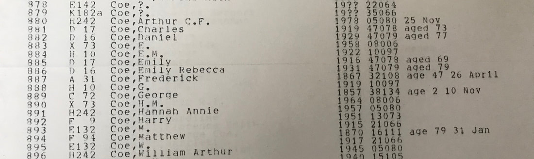
The earliest mention that I can find of the Coe family, living within Cherry Hinton, on the Parish records is dated 27th November 1782 when William, son of Richard & Mary Coe is born.
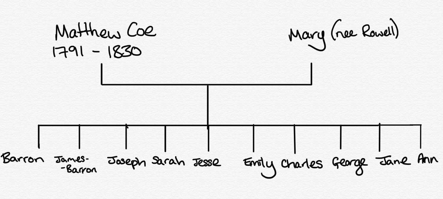
From the family tree research that I've just carried out on the Coe family, Richard Coe was born in 1756 and died in 1835 (79 years old). He was married to Mary (nee Witt) born 1752, died 1830 (aged 78). They had the following children:
William 1782-1783 - died aged c.1 year old, William 1788-1865 - died aged 77 years old, Matthew 1791-1870 - died aged 79 years old. 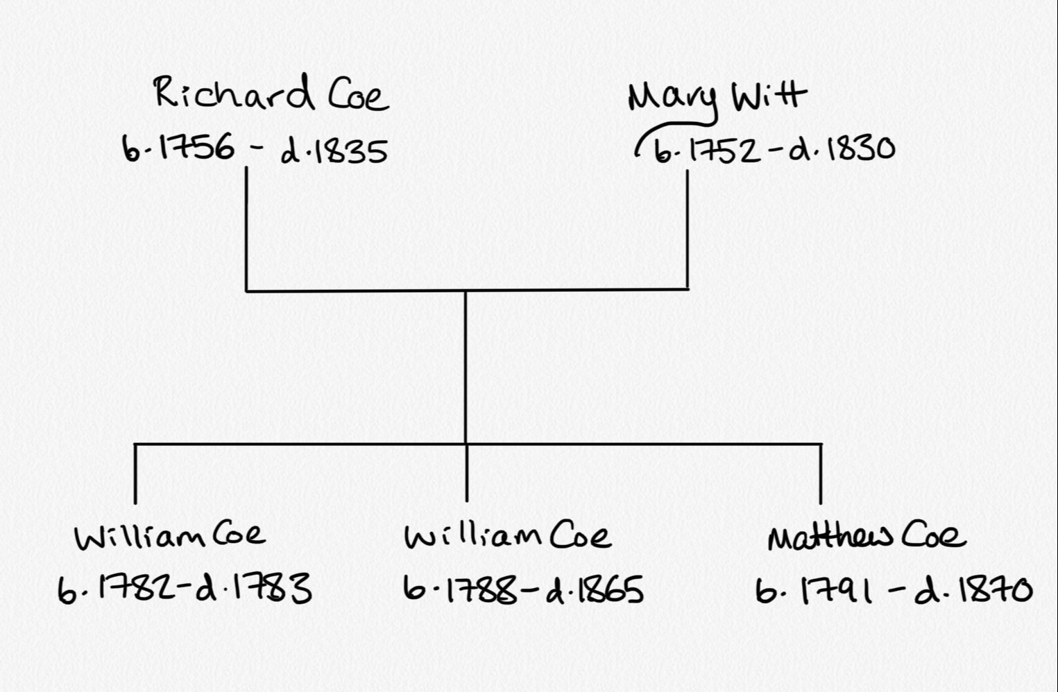
The following articles appeared in the Cambridge newspaper relating to Richard Coe of Cherry Hinton, the same Richard Coe as mentioned above:
3rd November 1815 (Cherry Hinton Chronicle, E.Filby)
“On Monday past, Issac Henly and James Howe were committed to the County Gaol, by John C. Mortlock Esq., charged on the oath of Richard Coe of Cherry Hinton, with having on Saturday last broken open his dwelling-house, in the day-time, no person being therein, and feloniously stealing taking and carrying away various articles of wearing apparel and working tools, his property.”
March 3rd 1816 (Cherry Hinton Chronicle, E.Filby)
“Cambs Assizes: On Friday last the 15th. Isaac Henly and James Howe, for feloniously breaking open the house of Richard Coe, of Cherry Hinton, in October last, and stealing some wearing apparel and other articles besides, were each sentenced to be imprisoned six months, and to be privately whipped.”
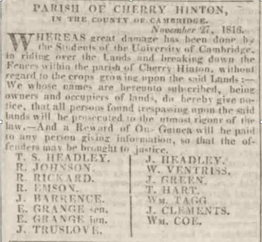
We then find reference to William Coe, Richard's son in the newspaper article below, stating that he is an owner and occupiers of lands - in the parish. He is amongst the owner/occupiers who had larger areas of land in the parish to manage, indicating that William is in some form of farming.
6th Dec 1816 (Cambridge Chronicle, British Newspaper Archive -BNA)
By 1841, On the 1841 Census for Cherry Hinton, we can see that there are three separate Coe households:
Matthew Coe, aged 45, gardener, with his wife Mary aged 40 and their children; Barron aged 19, James Barro aged 17, Joseph aged 15, Sarah Ann aged 13, Jesse aged 11, Emily aged 9, Charles aged 7, George aged 5, Jane aged 3. William Coe, aged 26, gardener, with his wife Charlotte aged 26 and their children; Gabriel aged 7, Arthur aged 5, Walter aged 4, Sarah aged 2, n-k aged 3. William Coe, aged 50, gardener, no wife so presumably widowed, and his children; Charles aged 22, Frederic aged 20, Martha aged 15, Benjamin aged 13, Naomi aged 8, Issac aged 6.
So there is William senior, aged 50, mentioned in the previous newspaper report. William junior aged 26 above is his son. Matthew aged 45 above, is William seniors brother/William juniors uncle. They have all stated their occupation as 'gardeners', this shows that they were in the business of market gardening, and probably orchard managing by this date within the village. It is tempting to start wondering how many of their orchard trees were from the old cherry tree stock which had given Hinton its prefix of Cherry by the 1500's - it certainly leads to the thought that the village may have been a place of orchards for many generations of villagers. They could have started working the pre-existing orchards but of course, they may have started afresh.
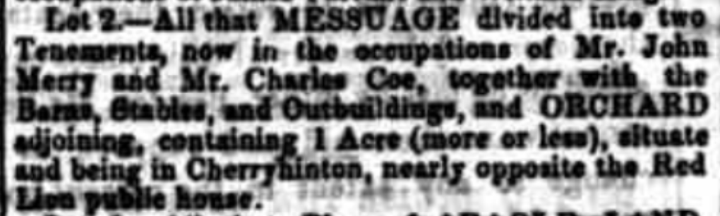
In 1850, we then find Charles Coe occupying property in the village, in Mill End, almost opposite the Red Lion pub in Mill End Lane. The property has an orchard, this may or may not indicate the form of faming that the Coe family were to specialise and expand into, soon after with their own farm, with the creation of Lime Tree Farm. This is the Charles, mentioned on the 1841 census, aged 22, son of William Coe snr. This Charles would now be about 31 years old in 1850.
23rd March 1850 (Cambridge General Advertiser, BNA)
Interestingly, next door to the Red Lion pub in Mill End remains one of the very old cottages of Cherry Hinton and it is named 'Orchard House'. This may be because it had views to the orchards around it or just coincidental but it is still worth a consideration.
In trying to trace the branch of the family that went from gardeners in the village to owning Lime Tree Farm, it is worth looking at each of the family lines in the village, mentioned so far.
Richard Coe, the first Coe that we see in the village died in 1830 - before the census records began - leaving his surviving sons, William and Matthew, with their family branches in the village. I have been researching their tree and have the following information so far... Starting with the first son, William Coe: 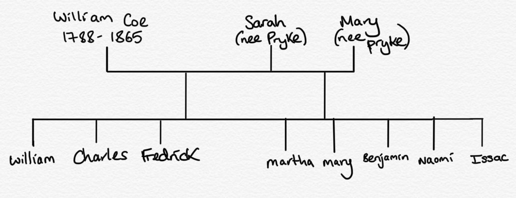
William Coe, 1788-1865 (died aged 87 years old), gardener, he first married Sarah ?-1822 (nee Pryke) in 1813 and after she had died he married, in 1825, Mary (nee Pryke) 1804-1837 (died 33 years old)- probably her sister.
His children with Sarah were: William 1814-1876 (died aged 62), married Charlotte (nee Missen) in 1834. They had several children including; Gabrielle, Arthur, Walter, Sarah, Mary, Ann, William, Jane and Frederick. They are shown as living on the High Street, next to the Red Lion pub on Mill End Cherry Hinton from 1851-1871 where William is listed as a gardener. The listings suggest that they are somewhere to the east of the Red Lion, where William's cousin Joseph (Matthew Coe's son) is living. This could be to the back area of the Red Lion on the High Street, where the post office area is today or on the other side of the road somewhere [edit: could be the cottages mentioned later in this article that lay opposite where the Post Office is today on the High Street - even possibly Apple Wood Cottage, which still remains today]. By 1881, William has died and his widow, Charlotte, is listed on the census as being a greengrocer, living in the next household from George Coe (Matthew Coe's son and her nephew) who was running Lime Tree Farm. So after William's death, Charlotte, along with her daughter Ann, goes to live and work, on or next to, the site that became Lime Tree Farm, on Cambridge Road (now Cherry Hinton Road). Charles 1818-1873 (died aged 55). Charles married Ann (nee Sizer). In 1851 he is listed as a gardener in Cherry Hinton. In 1861, again listed as a gardener, it is shown that he is living with his wife and children in Mill End Road - so as you can see this now tally's with the 1850 newspaper report shown above. By 1871, they are living in Russell Court, Cambridge, where he is still listed as a gardener. He had several children, including Elijah, Ann, Charles, William, Sarah and Jonah. Frederick 1821-1867 (died aged 46) - Frederick is shown working as a gardener at Hinton Cottage in Cambridge. In 1851 he then marries in 1855 Sarah (nee Beales) and they live in Cherry Hinton. In 1861 he is shown as a farmer/gardener employing 2 men and living, with his wife, on the Fulbourn Road to Cambridge. (* Cherry Hinton Road, as it is today, is referred to most often as Cambridge Road, also Fulbourn Road in the older census) They have 2 servants, one a farm servant and one a house maid. They do not have any children. [edit: if you scroll down to the 1883 map below, you'll see a building named Hinton Cottage, this is where Frederick and his family were living in 1851 until his death. It is just to the west of what became the Lime Tree Farm site and the next house along from Provident Cottage, occupied by Mrs Coe]. His children with Mary were: Martha 1825-1898 (died aged 74) - Martha married James Morley in 1853 and they both moved to 63 East Road in Cambridge, where they remained until their deaths. James was a shoe maker and Martha a Laundress. They have no children. Mary 1836-1868 (died aged 42). In 1844 Mary marries James Banyard, an agricultural labourer, they have several children and in 1851 are shown as living in Barron Lane (now gone) in Cherry Hinton. Benjamin 1828-1869 (died aged 41) Benjamin does not marry or have children - you can read more about Benjamin's tragic death below. Naomi 1833-1877 (died aged 44) - Naomi married Joseph Darley and agricultural labourer. In 1861 they are living in the High Street. Then her husband Joseph is listed as a widow in 1881, living in Fishers Lane. By 1891 he is living in the Almshouses (which are opposite the Red Lion pub in Mill End). They do not have children. Issac 1835-1855 (aged 18).
In 1860, we find reference to Frederick Coe, mentioned above, who is working the land on Lime Kiln Hill, this could have been general arable farming or even orchard farming but it could be that he was running a lime pit or chalk extraction enterprise as these pits were on Lime Kiln Hill and very popular at this time.
5th May 1860 (Cambridge Independent Press, BNA)
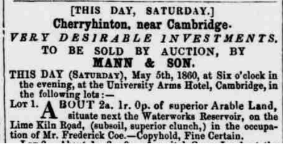
However, we now know that Frederick was listed as a gardener at this time (1860/1861), so managing the orchards which were on Lime Kiln Hill at the time is most likely.
Then in 1869, comes the tragic news of the death of his brother Benjamin Coe:
20th November 1869 (Cambridge Independent Press, BNA)
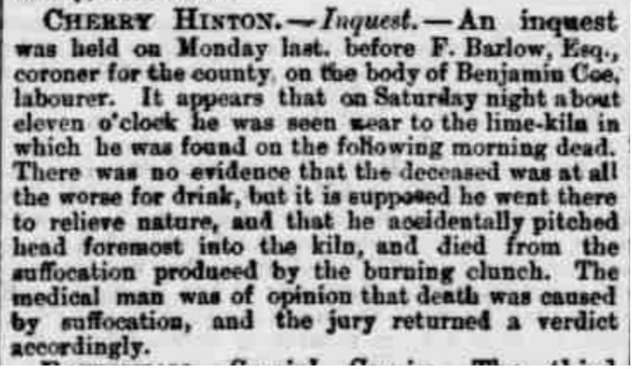
It is worth noting that on the 1861 census, prior to Benjamin's death, he was also listed as a gardener and no mention at that point of him working at the lime pits, which puts me back to wondering if he and his brother Frederick did indeed manage or own one themselves. However, although Benjamin is found dead in one of the lime pits, it was not an accident whilst at work, as it states he was 'reliving nature' on a Saturday night, not that he worked at the lime pits.
Ultimately this brings an end to William Coe's family line for being the ones running what was to become Lime Tree Farm on Cherry Hinton Road. To find out which Coe line did manage the farm, we must now turn to his brother Matthew Coe, to see what happened with his branch of the family.
The question is, with so many of them being listed as gardeners - how many of them were actually working on Lime Tree Farm whilst living in the village - it is certainly a family occupation. How many of them held orchards or market gardens elsewhere or independently?
The second son, Matthew Coe:
Matthew Coe, 1791-1870 (died 79 years old), gardener, he married Mary (nee Barron) in 1820. In 1841 Matthew is listed as a gardener in Cherry Hinton but then in 1851 we find Matthew is listed as living on Cambridge Road (now Cherry Hinton Road) and that he is a gardener of 9 acres! Add to this that the next property along on the census is Park Gate House - which is the lodge house to Cherry Hinton Hall, which was next to Lime Tree Farm - now means that we have our first clear piece of evidence that the site of Lime Tree Farm was in existence by 1851 and in the occupation of Matthew Coe! (*The farm may have been called something else or just Coe's farm, or could have been named Lime Tree Farm from the start but the earliest documentary evidence of the name Lime Tree Farm, the I have so far, isn't seen until 1901).
Matthew's children with Mary were: Barron 1822-1865 (aged 43). Barron married, in 1843, Maria (nee Rowell) and had several children including: Maria, Mary Ann, Jesse, Matthew, Barron and James. In 1851, they were living on Ely Road in Chesterton, Cambridge, where Barron was listed as being a gardener. By 1861, Barron and his family have moved back to Cherry Hinton and are living on the High Street where he is still listed as a gardener. James Barron 1821-1913 (92 years old). James married, in 1860, Mary Ann Darby. Mary is a laundress. They had several children including Alfred, Daniel (who was also a gardener), Naomi, Lilly, Florence and George. They lived on Fishers Lane for most of their married life, where James is listed as a market gardener, before retiring to their son Alfred's house in Romsey, Cambridge. Joseph 1826-1898 (aged 72) marries Susan (nee Fuller) and they have several children including: Harry, Issac, Levi, Rebecca, Joseph, Matilda and Josiah. In 1851 Joseph is a publican and gardener living and running the Red Lion pub in Mill End, Cherry Hinton. 1861 he is just listed as publican, no longer gardener and is still running the Red Lion pub in Mill End. By 1871 they are living on the High Street and he is a bricklayers labourer, in 1881, still living on the High Street, he is working as a railway labourer. They end up, by 1891, living at Cyprus Place, Cambridge, where he is then listed as a bricklayers labourer. Sarah 1827-1912 (aged 85) married James Smethers in 1849. They have several children including; Matthew, Emily, John, James, Fanny and William. Her husband James is an Iron Founder. In 1851 the are living in Cherry Hinton in Grove Cottage on Ford Way (which I believe to be Daws Lane, through my other research). In 1861 they have moved to Shoreditch, London and then on to Liverpool Street, London. After James dies, Sarah remarries Robert Blinco, who is a Shepherd. They live in Swaffham Bulbeck, where Sarah remains until her death. Jesse 1830-1909 (aged 79) married, in 1852, Delilah Cornwall. They have several children including; Eliza Ann, Arthur Cornwell and George. By 1881, they are living in Hay Street, Fulbourn where Jessie is working as a railway plate layer. By 1891 they had moved to Marmora Road, Cambridge where Jessie continued to work on the railways. Emily 1832-1903 (aged 71) married Charles Short, a stone mason and they have several children. They move a lot presumably to do with her husbands job. They go from Hawkhurst, Kent in 1861 to 6, Liverpool Street in London in 1871, then on to Cheetham, Manchester by 1891, before ending up in Bootham, York. Charles 1833-1913 (aged 80) married Elizabeth and in 1861 they were living in Fisher's Lane, Cherry Hinton, where he was listed as a gardeners labourer. By 1871 they had moved to Teversham High Street, where he was still listed as a gardener. They had several children, including: Alfred, Ellen, Herbert, Zellah, Bertha, Mary Ann, Jane and Charles. By 1881 they were living in Bull's Row, Cambridge and Charles had become a railway labourer. From 1891 until his death in 1911 Charles lived at 36 Cockburn Street, where he was a railway labourer until 1901 when he lists as a bricklaying labourer. George 1837-1919 (aged 92) - George married Elizabeth Mary and they had several children including: Jesse, Herbert Matthew and Lizzie Grace. George was the son which took on the farm (site of Lime Tree Farm) on Cambridge Road, from his father Matthew. In 1871 he is listed as living on Cambridge Road (now Cherry Hinton Road) as a Market Gardener and Farmer, farming 15 acres with 3 farmers employed. He is still there in 1881, 1891, 1901 and 1911 with his wife and all at the same place, with the sons Jesse and Herbert listed as Market Gardeners too. See more on George in the below sections. It always starts to get more challenging when they name their children after other family members :) Jane 1838-1849 (aged 11). Ann 1841-1841.
I hope some of you are still with me on this... I write out as I go, to get my notes and research somewhat organised, discovering things along the way and trying to make sure I get some sort of coherent order for myself should I come back to do more delving at some point. With any luck it will be of some interest to you readers out there too.
To recap so far:
Richard Coe comes to Cherry Hinton (no records found yet of his being born here) he marries Mary Witt, a Cherry Hinton girl. They settled down in Cherry Hinton and have three children. William, their first child dies as a baby. They go on to have at least two more children - William and Matthew. Richard's son William marries twice and has several children, some stay in the village others move away and some die young. William is listed as a gardener. Richard's other son Matthew, also listed as a gardener, marries Mary Barron and has several children, again some stay in the village and some move away but his son Matthew is the first known occupier of the site that was to become Lime Tree Farm from at least 1851. Matthew's son George then takes over the running of the farm as a market gardener and lives there, until his death in 1919.
Market Gardening was a style of farming fruit and vegetable produce, sometimes also flowers, as apposed to general agricultural or dairy farming. you can read a little about it here: History of Market Gardening.
The produce was sold direct to customers, markets and restaurants. With the creation of Cambridge Road (now Cherry Hinton Road) after Enclosure in the early 1800's, the positioning of a Market Garden Farm on this road would have been most convenient to access, not only the Cambridge town market and retailers, but also Cambridge train station (and for a short while Cherry Hinton train station, when it was open) to carry produce to the London markets and retailers.
We will now start looking at Matthew's son, George Coe 1837-1919, to see what becomes of Lime Tree Farm and who next takes it over. Along the way, still including a few local articles about the Cherry Hinton branches of the Coe family.
This next newspaper entry in 1878, refers to Matthew's son George Coe....well... hmm :)
6th April 1878 (Cambridge Independent Press, BNA)
As stated previously, George Coe married Elizabeth Mary Veil and they had three children, Jesse, Herbert Matthew and Lizzie Grace. George was the son which took on Lime Tree Farm from his father Matthew. Of George's children, it is Jesse and Herbert who are still living at the farm and listed as Market Gardeners in 1911.
The daughter, Lilly Grace marries first Jack Bass who dies in WWI 16 Aug 1918 in France and Flanders. A good while later, she remarries to Walter Kester and they go on to live in Hills Road, Cambridge. We'll look at Jesse and Herbert Matthew next to see which one takes on the farm, after George's death. But before that, a bit of a catch up on other Cherry Hinton based Coe family news to bring us up to date to Jesse and Herbert.
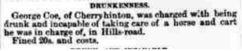
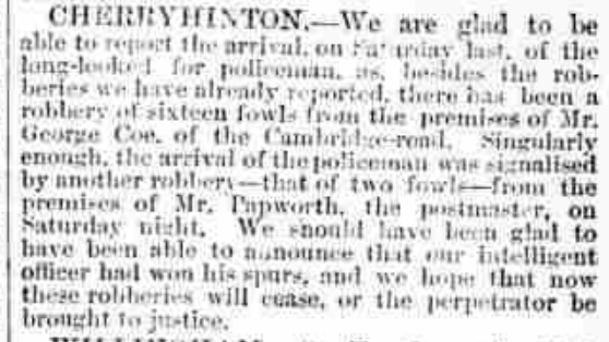
In 1880, we find a newspaper article describing the robbery of fowls from Mr George Coe's premises (Lime Tree Farm).
October 16th 1880 (Cambridge Independent Press, BNP)
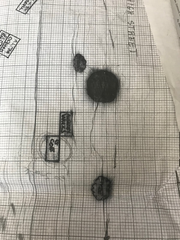
The earliest map, showing the site of Lime Tree Farm, that I currently have, is from some sale particulars of land that is being sold, in Cherry Hinton, by the trustees under the will of John Okes, Esq. - John Okes was the owner of Cherry Hinton Hall, the Hall was built in the 1830's, after John Okes had taken advantage of the land sales post Enclosure. He died in 1871 and most of his land then went into the hands of Cambridge University and Town Waterworks Company (which his brother Richard Okes was part of). John Okes had previously purchased the land needed for the building and laying out of Cherry Hinton Hall, along with a good amount of other plots within the parish. (I will do a separate blog on John Okes and Cherry Hinton Hall, I am also writing the History of Cherry Hinton Hall which will be published in book form shortly.) After his death, many of these plots were put up for sale, as you can see from the map below, on the coloured and numbered lots. The advantage to this is that we now have a good picture of the Lime Tree Farm site.
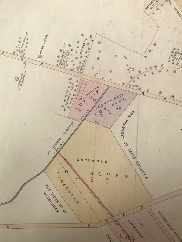
Sale map of land in Cherry Hinton, 1883. (Cambridge University Library, maps.PSQ.x.18.36)
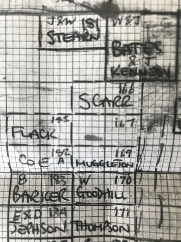
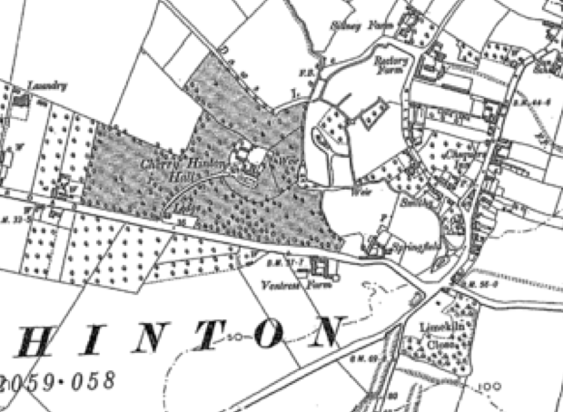
Below, I have placed the same map again, with some annotations, so it is easier to see what and where we are talking about. The area circled in red is in the Coe family land and property. At this point, 1883, you can see the site of what is to be called Lime Tree Farm. The earliest reference that I have found, naming the site Lime Tree Farm is on the 1901 OS map. I've marked the Coe farm buildings in red. In 1883, we can see that there are three buildings on the northern side of Cherry Hinton Road and one on the southern side. Bearing in mind the purpose for which this map was produced - to show sale plots, always be cautious and remember that not all detail is always shown. However, that said, this map does give a fairly good picture and we can clearly see the extent of the Coe's nurseries and orchards at this point, marked on the map by name and the tree pattern.
If you look at the building on the southern side of the road, marked Mr George Coe. You will see that the trees within this plot are marked as being much more uniform in their layout to those across the road. This would suggest to me that this is a more recent plot or orchard trees, than that of those over the road. It is a deliberately laid out orchard, where as trees on the northern plots are a little more scattered. As for the 4 buildings in total, this is interesting because, as many of us locals may remember, from the time Mr & Mrs Coe (Cyril & Eileen) had their shop at Lime Tree Farm, there was one house and some barns out the back. So this begs the question, which one of these buildings remained as the main Coe family house, the one many of us had been in to buy things from, in living memory. We can not be totally sure which of these four building shown were occupied as dwellings by the Coe family or which may have been farm workers cottages or even which may have been large barns. We can see that there is a building named Providence Cottage and marked as though Mrs Coe owns/lives there. Next to that, abutting the main road is another building unnamed and then follows a third building marked Mr Coe. The main nursery, which became Lime Tree Farm lays out the back of these buildings. Over the road, we have the more formal orchard lay out belonging to Mr George Coe and an unnamed building. (Edit: now known that Fredrick Coe lived with his family, from at least 1851 to his death in 1867, at Hinton Cottage, the next house along to the left from Provident Cottage, shown below. Hinton Cottage stood between Laundry Lane and Derwent Close, on Cherry Hinton Road, where there are now a set of 20th century houses). 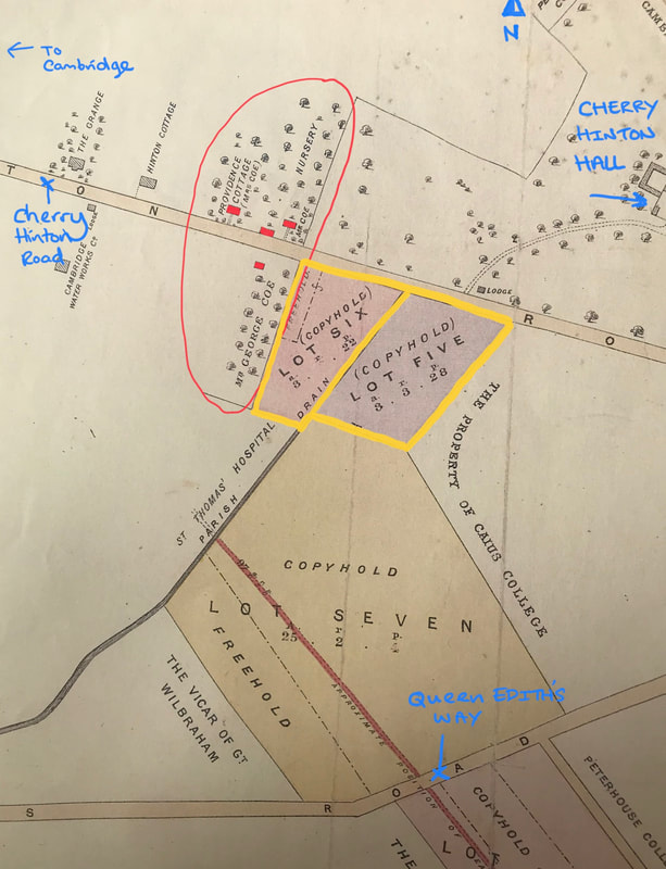
Sale map of land in Cherry Hinton, 1883. (Cambridge University Library, maps.PSQ.x.18.36)
Remember that Matthew Coe had been first on this site, on the northern side of Cherry Hinton Road, from at least 1851. Matthew Coe dies in 1870, leaving his son George managing the whole operation. So when we look at this map in 1883, what we are seeing is a site managed by George Coe.
Take note of the the two lots, 5 & 6, which are to be sold and which I have marked in yellow. We will come back to those shortly. First of all, I'd like to just place those 4 buildings, which I have marked in red above, on a modern map to see which one became the Lime Tree Farm house that many of us knew before it was pulled down about 15 years or so, ago. 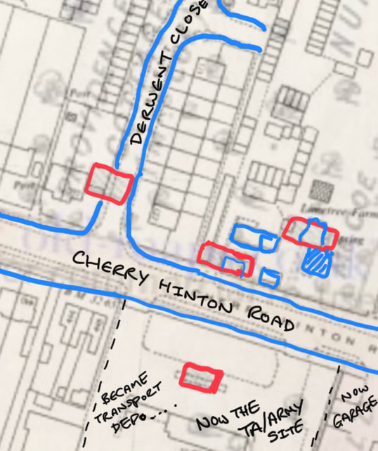
Very rough little check of the 1883 map overlaid with a 1970's OS and then marked up to give rough estimates of where the 4 buildings on the 1883 map had once stood.
I have marked the same red buildings that I marked on the 1883 map above, again marked in red on the overlaid 1970's OS map (blue buildings are some of the 1970's buildings) to see roughly where they once stood.
Providence Cottage, which was shown as in occupation of Mrs Coe in 1883, top left of the picture, was demolished when the Derwent Close estate was built c.1960's. any remains are now beneath the road and in the gardens of the houses that now stand there. 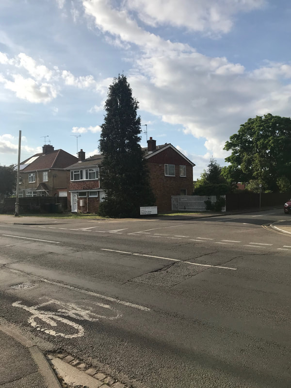
Once the site of Providence Cottage.
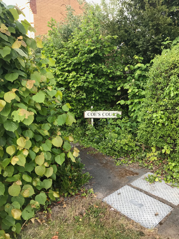
The next red building along, moving right on the picture, is again beneath more housing. Now Coe's Court.
Coe's Court, where the second red building stood (barns):
The top right red building, which was marked Mr Coe on the 1883 map, has the building, probably extended and altered somewhat, which us locals knew as Mr & Mrs Coe's shop/Lime Tree Farm.
The 3rd red building, the one that became the Lime Tree Farm house that many of us locals still remember, stood between the two aerials in the picture above (between the new Coe's court houses and the bungalow on the right).
The 4th red building shown on the southern side of Cherry Hinton Road on the 1883 map and marked next to the orchard plot George Coe, became the site of the old transport depo by the 1960's and is today the Army/TA Centre.
So it appears that it is the top right red building, on the 1883 map, that remained the longest and became the main house. 
The site that once was Hinton Cottage, as shown on the 1883 map
The next thing I'd like to do is have a quick look at the 1881 census for Cherry Hinton again, to see if we can now place who was living where, out of these 4 buildings and if they were all dwelling houses.
There is no one living in the building on the southern side of the road - suggesting that it was some kind of large barn perhaps. There are three Coe households on the 1881 census, which we can tentatively say correspond to the three buildings. The first building of Providence Cottage has Fredrick Coe - engine driver, with his wife Mary and their children Frederick, Mable, Alice and Arthur. (*Note that this is not the Frederick who had lived in Hinton Cottage because he died childless in 1867. This is Frederick who's mother is mention next). Next along we have Charlotte Coe (widow) greengrocer, with her daughter Ann and grandchildren Nellie and William Reynolds. - although I'll note here now, that I think that it is quite probably that these two listed households of Fredrick and Charlotte's may well have all been within Providence Cottage and that the second red building along, unnamed were barns or such like (not least because I remember playing in those barns when I was young.) Then on the 1881 census, in the third red building on the northern side of Cherry Hinton Road, to the right on the maps above, marked 'Mr Coe' on the 1883 map, was George Coe, market gardener aged 45 with James Shyles, agricultural labourer and servant. This building being the most likely candidate for the original farm house that George's father, Matthew had occupied.
So back to that sale map of 1883 - do you recall the yellow lined plots 5 & 6 that I said we'd come back to? Have a quick peep at them again and then look at the map below from 1885.
Firstly, here are the two lot descriptions given with the 1883 sale map, for lot 5 & 6.
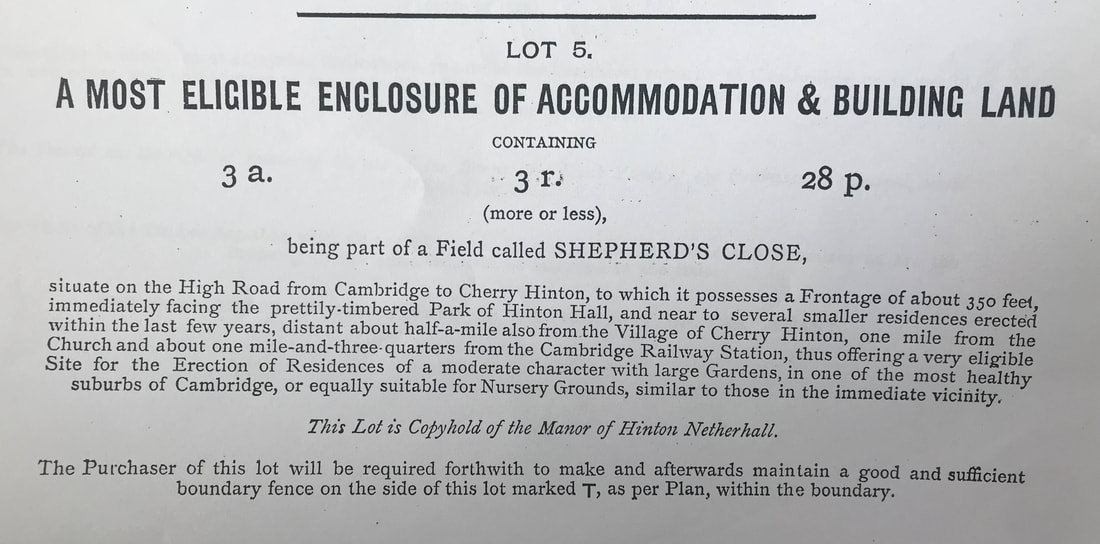
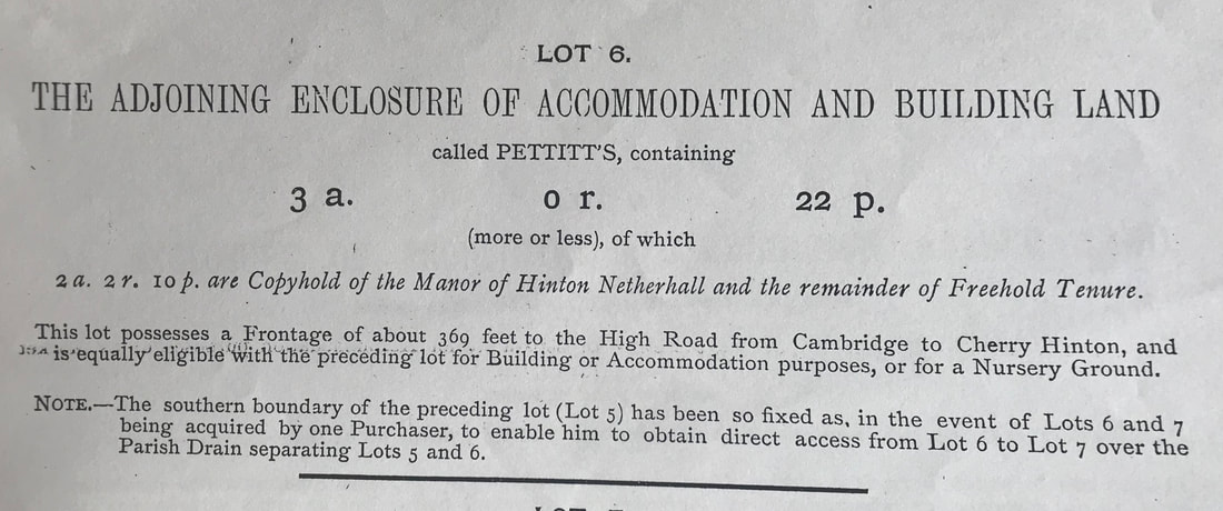
Sale particulars of land in Cherry Hinton, 1883. (Cambridge University Library, maps.PSQ.x.18.36)
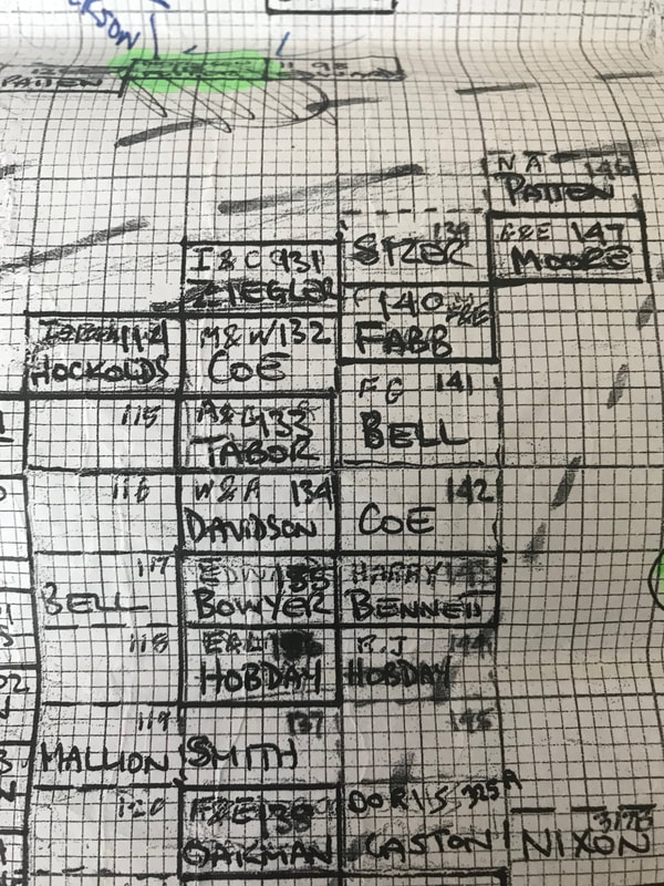
The later OS map of 1885 shows us the site of Lime Tree Farm and the extent of its land and orchards at this date. You will be able to see on the annotated version beneath, that George Coe purchased lots 5 & 6 and even another plot beyond those in a separate sale and turned them all into orchards, as demonstrated by the uniform pattern of trees on the map.
Cherry Hinton, 1885, Ordinance Survey Map
Annotated Cherry Hinton, 1885, Ordinance Survey Map
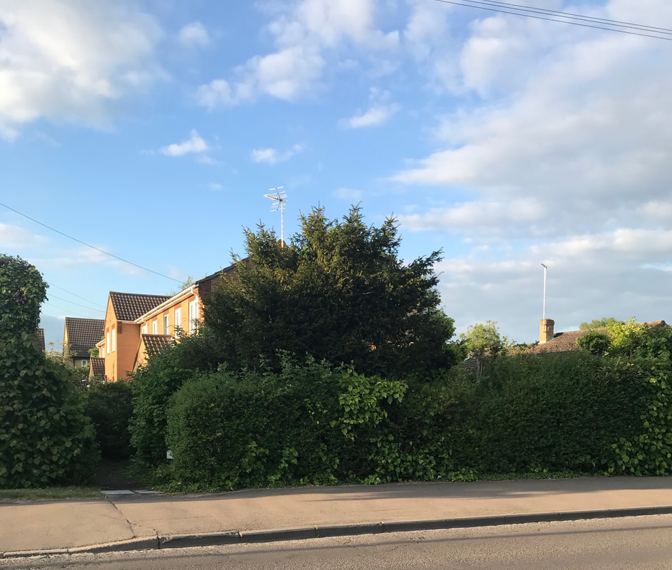
Lot 6 is today where the BP garage is (* as explained in a later blog about Cherry Hinton Hall, the western end of the Hall grounds were sold off in the late 1800's and the Walpole Road estate was eventually built on that patch).
Lot 5 became the Glenmere Close estate. The orchard area to the right, which Coe also purchased (or potentially just rented) became part of Netherhall Lower School front playing field (I can remember playing hockey on that field!). This plot is now under the houses of the Bosworth Road estate.
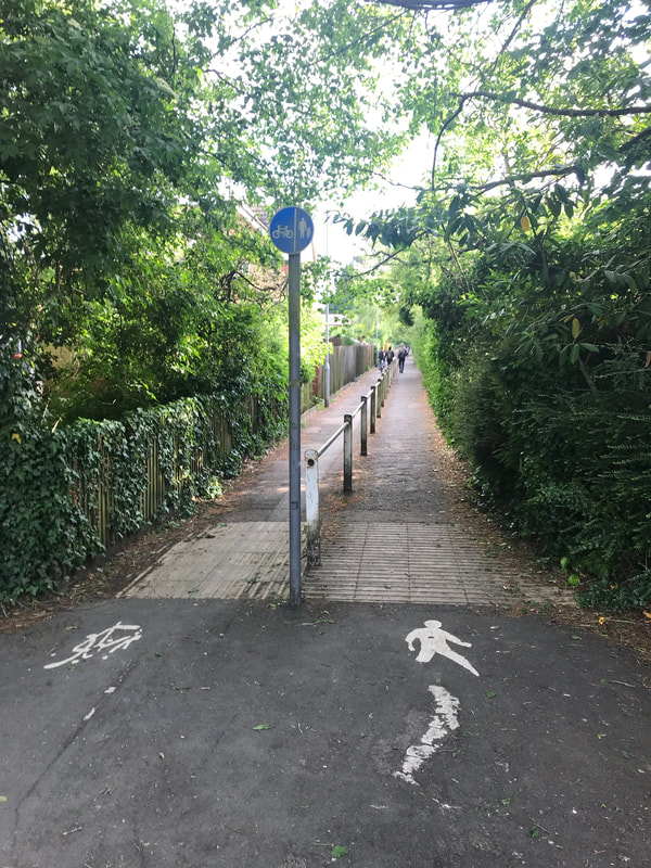
The black dotted line that I have placed on the map above shows, where today, the passageway that leads from Cherry Hinton Road to the gates of what was Netherhall Lower School, now the Queen Emma School, still remains. Many of us locals will remember going through that passage to either get to school or the Netherhall Youth Club building that once stood on the school site. It is still a popular through route for people living on the Gunhild/Queen Edith's sites to get through to Cherry Hinton Hall and generally just a good cut through, when on bike or foot.
The passage-way between Cherry Hinton Road and Queen Emma School/Gunhild Way, running between what was two of Mr Coe's orchards:
Let's continue down the time line, at what event's were recorded.....
In 1894 - we can see that Cherry Hinton had a Cottage Garden Society, in the article below, of which the Coe family were part of:
July 20th 1894
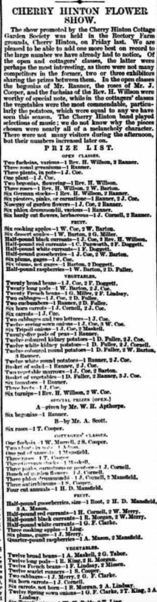
FLOWER SHOW The fifth annual Show of the Cherry Hinton Cottage Garden Society was held yesterday in the grounds of Cherry Hinton Hall. The weather though threatening at first, was very fair. The Cherry Hinton brass Band played a selection of music during the afternoon and evening. The exhibits were arranged very tastefully in a large marquee. Dr Lyon's fuchsias and geraniums were especially worthy of notice. The judges were Mr. Missen, Fulbourn and Mr A. Coe, Cherry Hinton... (Cherry Hinton Chronicle, E. Filby)
In 1888 at a village meeting, Daniel Coe is appointed constable for the year - this is repeated several times over coming years. Daniel Coe is Matthew's grandson (son of James Barron Coe). See newspaper article below:
30th March 1888 (Cambridge Independent Press, BNA)
In 1888 mention of Widow Coe is made, occupying a cottage in the village. I wonder which one it is referring to - I'll try and find out at some later point - see below:
10th August 1888 (Cambridge Chronicle, BNA)
Decided to have a quick look at the 1881 census to see if there was any correlation of the names mentioned above in that article, with households living next to, or being listed next to one another. There is. We can see that on the High Street Cherry Hinton, in 1881, there are the following families in listing order: Jackson, Merry, Coe, Tabour and then Farrent. All apart from Tabour, matching a few of the names shown above in the article from 1888. So the cottages mentioned above are likely ones that stood on the High Street.
I think I know where these cottages stood...potentially. Some years ago I was arriving at a Cambridgeshire Association for Local History committee meeting in Cambridge Central Library, when as soon as I got in the door, Mike Petty (our brilliant Cambridgeshire Historian) collared me and said, get down to the market (Cambridge) now, there's a painting of Cherry Hinton that is not in the Cambridgeshire Collection and I haven't seen it before. Go and buy it quick! I duly got down to the antiques stall on the Cambridge Market and found the painting in question. Trouble was they wanted £80 for it, which was a lot to me then, anyway, I forgo my bill money and got the painting quick. Later once home, I studied the picture to work out where the view was in the village. I then had a few A3 copies of it made, deposited a copy in the Cambridgeshire Collection and Cherry Hinton Community Archives and then door knocked on a few of the doors of houses, which were stood at the site of the where the buildings in the picture were shown, and sold a few of the pictures to get back some of my bill money. The original painting now lives with Mr David Taylor, chair of the Friend's of Cherry Hinton Hall.
Here is that picture:
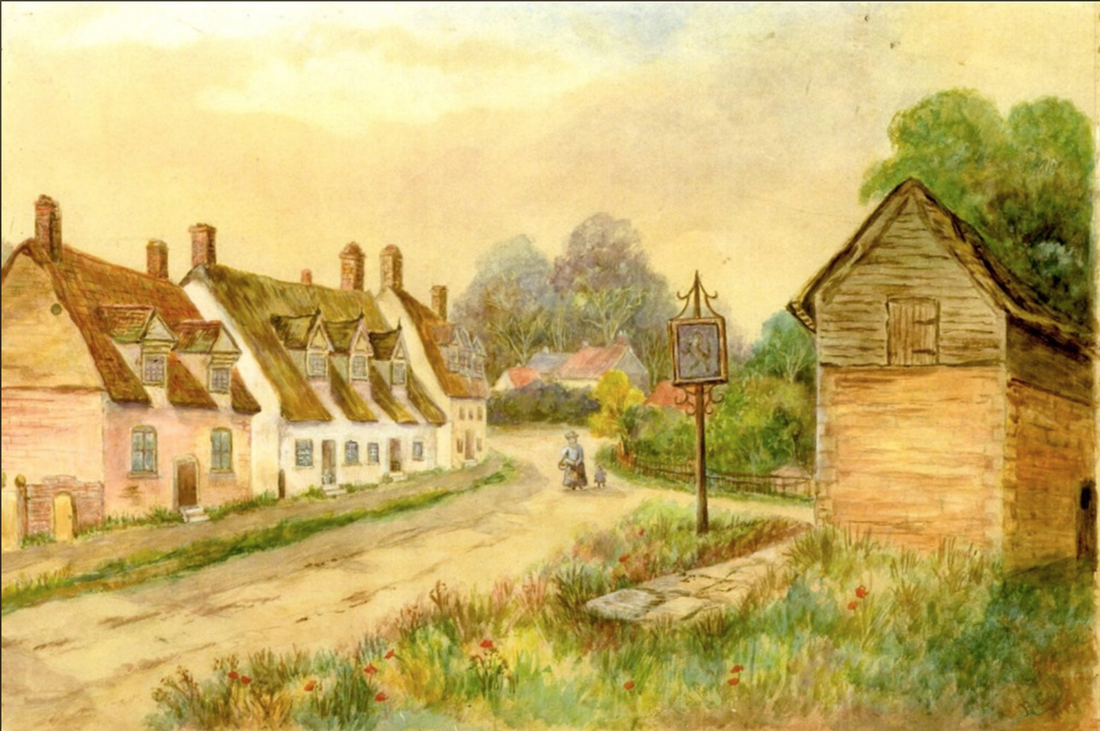
View of Cherry Hinton High Street c.1917
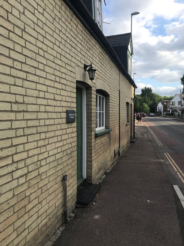
This is a view painted from what was part of the village green in Mill End (a Funnel green), where the Indian Restaurant now stands (previously The Unicorn Pub) looking down the High Street towards the Robin Hood. The buildings in the centre of the picture, above the head of the lady, are the old Robin Hood pub - the tall trees beyond are the start of The Spinny and the quarry on Lime Kiln Hill. The area to the left of the lady (our right as we look at the picture) is where Giants Grave and the village green extended to and which the post office and laundrette now stand on. The road branching off to her left is Mill End Road. The pub sign that you see is a sign for the Red Lion pub which is down Mill End Road and was to direct travellers down the road, as they could miss it if they carried on up the High Street. The building standing on the green is most likely the village pound or a storage building (it is not to say that the Unicorn pub isn't there behind our view at this date but it is not the pub itself).The row of cottages on the left of the painting, you can in fact still see the remains of today if you look carefully. The only fully remaining one of these cottages today, which is again behind us in this view, is Applewood Cottage by the recreation ground.
This view shown in the painting more or less, as it is seen today -more from the other side of the road.
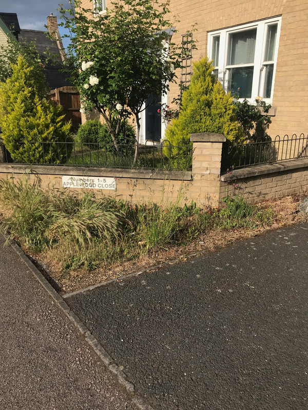
Below pictures of Applewood Cottage and Applewood Close (note the name - does it relate to more of Coe's orchards or just coincidental.) Mrs Coe, mentioned in the news article above, lived along here, maybe in what became Applewood Cottage or one of the buildings shown on the old painting. Note that the style of Apple Wood Cottage is the same of those as in the painting.
The three pictures below show the remains of the cottages, shown in the old painting, that you can still see for yourself today and are in the garden walls of the houses that are there now - you can even see the old doorways if you look closely. The first photo on the left, below is looking across the road from the Post Office on the High Street. Look at the middle photo, look closer in the front garden wall and you'll see the original cottage wall and a now bricked doorway. 3rd photo on the right shows more of the old brick work from those cottages - one of the Coe families houses? Go and have a look when you get chance yourselves :)
Let's continue onward with looking for the Coe's of Cherry Hinton and Lime Tree Farm....
The first real hint, within the newspapers, of the Coe family being involved and keen on growing a variety of market garden produce, comes with the report in 1890 of the Cherry Hinton Flower Show, where the produce shown by J Coe include such vegetables as turnips, potatoes, onions and beans....(which J Coe though?- probably Jesse?)
1st August 1890 (Cambridge Chronicle, BNA)
In 1891, George Coe is mentioned in the sale of some land, - see below - which is not on the site that became Lime Tree Farm but shows that the Coe family were very much part of the village by this point, working the land and being involved in village activities. For example, within meeting reports we find that various members of the family are involved with both the Conservative Club and others with the Liberal Club.
18th July 1891 (Cambridge Independent Press, BNA)
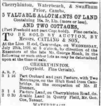
In 1894, we find a Mr Frederick Coe listed, who is a market gardener and farmer. The report however is from the village of Histon, to the north of Cambridge, not Cherry Hinton. It refers to a bad accident that Mr Coe had. But how likely is it that this Coe is related to the Cherry Hinton Coe family? - I don't have him on the Coe family tree yet but it is a very likely possibility that this person, given his profession is part of the same extended Coe family. I will come back to him another time and add to the end of this blog, any links that I discover about this branch of the family, - which is worth looking into because this particular Frederick Coe was born around 1824 in Impington, Cambs. Perhaps we will discover a link to where the first Coe in Cherry Hinton (Richard Coe) came from, perhaps the original family hailed from those parts in the first place? and if you are a Cambridge person you'll know what one of the main occupations Histon became well known for... The Chivers fruit farm and factory, which almost every one in Cambridge of a certain age range can remember working for, or a family member working for at some point - my granny Toller did - I wonder.... given the nature of the Coe's farming if there is any link to what became Chivers... see this is the trouble! A whole new thread to follow and what starts out as a little blog on Lime Tree Farm becomes the start of a book ..... As tempted as I am to go off with this new exciting hint... I will stay in Cherry Hinton for now and maybe add on something at the end of this if I find out more - or I'll just do a separate article on it.
17th August 1894 (Cambridge Chronicle, BNA)
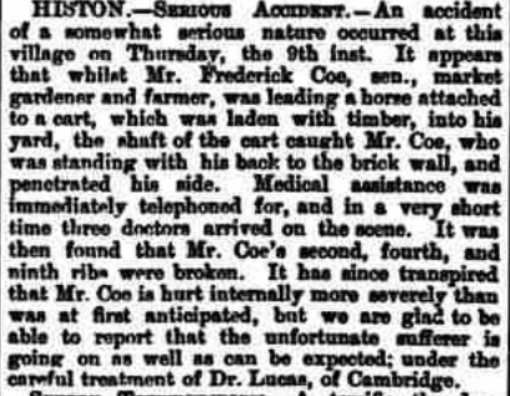
In 1895 we find reference to Arthur Coe as a gardener - most likely Jesse and Delilah's son. If so, this incident occurred on Lime Tree Farm site, as Jesse is shown on the 1891 census, living there at this time.
12th April 1895 (Cambridge Chronicle, BNA)
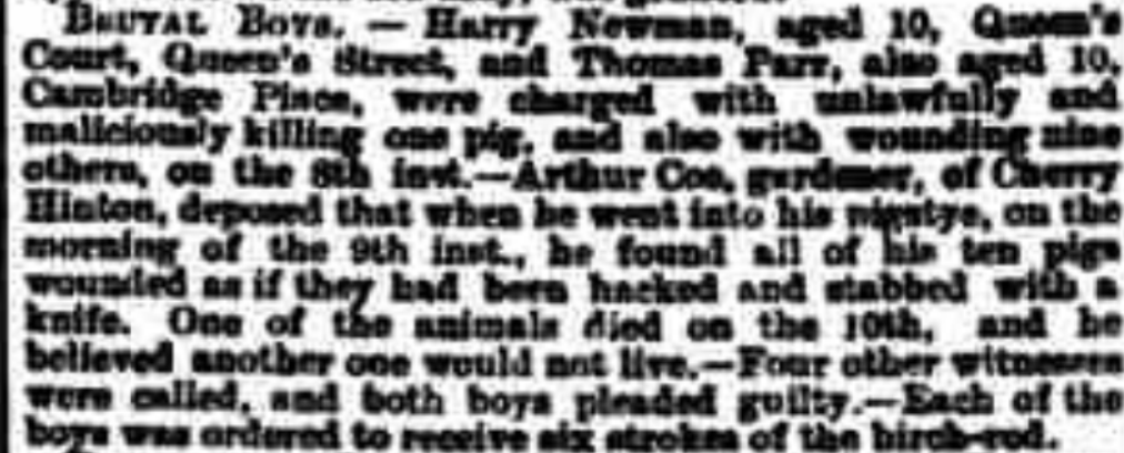
1899 and more evidence of the family enjoying village life with John Coe playing the cornet in the Baptist Chapel on Fishers Lane. John is one of the Coe grandchildren, somewhere along the line.
4th April 1899 (Cambridge Daily News, BNA)
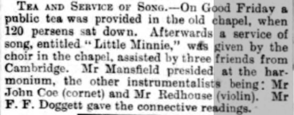
The William Coe mentioned below is probably Charles Coe's son.
18th October 1891 (Cambridge Independent Press, BNA)
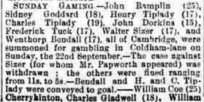
1901 - on the 1901 Os map below, you can see some of the changes that have occurred at the Lime Tree Farm site and the orchards. You can see that the transport depot had taken over the land directly opposite Lime Tree Farm and the dotted, parallel lines marked over the west end of the grounds of Cherry Hinton Hall were marking out where Walpole Road was to be built.
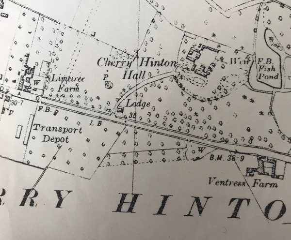
OS map surveyed in 1885, revised in 1901.
Here's an article mentioning the marriage of George Coe's daughter Lilly, with many members of the family travelling to London for the event. Sadly Jack, her husband was killed in the war, soon after. Lime Tree Farm is mentioned by name in this report.
Friday 24th September 1909 (Cambridge Independent Press, BNA)
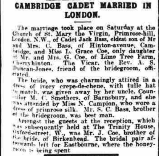
So back to which son takes on Lime Tree Farm after George Coe's death in 1919 - Jessie or Herbert? From the newspaper clip below we can see that in 1917, when George Coe was very elderly, that Jesse, perhaps, is already in charge of Lime Tree Farm.
August 22nd 1917 (Cambridge Daily News, BNA)
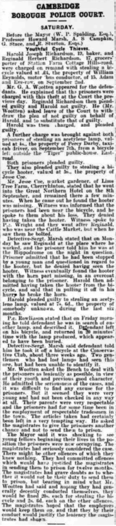
The death of George Coe is in the papers. The 'Gracie' mentioned is his daughter Lilly Grace.
24th January 1919 (Cambridge Independent Press, BNA)

22nd January 1920 (Cambridge Daily News, BNA)
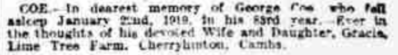
The probate record doesn't appear to show that much was left, so perhaps, at some time before his death, George had handed over the farm and estate to his son/s.
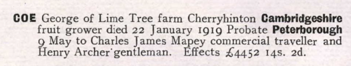
Probate entry for George Coe
Herbert Matthew Coe:
Starting with Herbert Matthew Coe 1884-1964. Herbert marries Elizabeth (nee Wright) and they have at least one child, Gracie Elizabeth. They go to live at number 51 Fulbourn Road, where Herbert works as a market gardener with orchards of his own to the back of his property on Fulbourn Road, east of the Robin Hood pub, on the main road through to Fulbourn village. You can see the orchards shown on the 1951 OS map below. There is now modern housing on the site and one of the roads is called 'The Orchards' after Matthew Coe's orchards. (to place yourself - the Cherry Hinton recreation ground is shown top right on the map and the orchards are shown south of this. along the bottom right is Fulbourn Road and running up through the map is Cherry Hinton High Street.)
1951 OS map, Cherry Hinton
This leaves George's son, Jessie, living at and managing Lime Tree Farm.
Jessie Coe: Jessie Coe 1883-1973, marries in 1928, Elsie Coe (nee Coxall). They have one son, Cyril. Jessie is listed in the Cambridgeshire electoral records as being a farmer and fruit grower. In 1950, Jessie submits plans to the Council - 'Building bylaw plan and approval for proposed extension to farm shop and Tea Room, Lime Tree Farm, Cherry Hinton Road' (Cambridgeshire Archives: KCB/2/SE/3/9/17630). This suggests that a tea room was already in operation by this point at the site. Elsie Coe ran the tea room and small shop. Jessie and Elsie Coe live at Lime Tree Farm, with their son Cyril, until their deaths, when Cyril then takes over the running of the site.
1939 - The 1939 OS map below shows that although the transport depot is has now taken over land opposite Coe's farm, some of their orchards still remain behind it. This is now the site of the Army Reserve Centre and the back of the Glenmere Close estate.
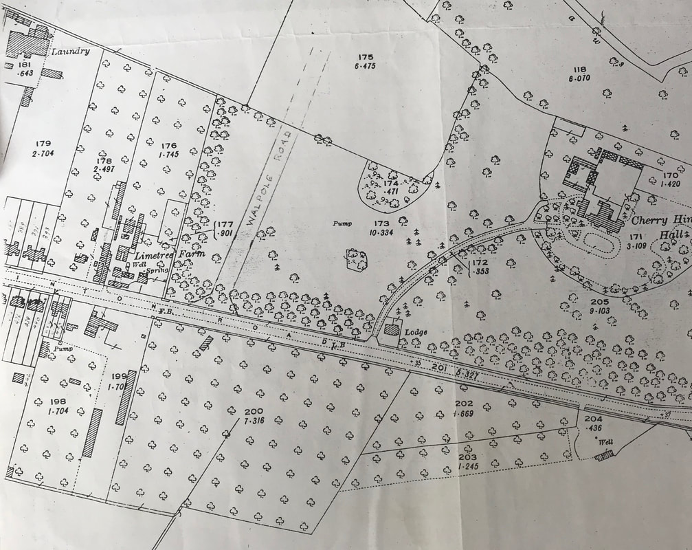
OS map 1927 revised 1939, Cambridge Record Office.
Below are two advertisements for produce from Lime Tree Farm.
27th June 1939 (Cambridge Daily News, BNA)
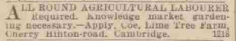
12th December 1939 (Cambridge Daily News, BNA)
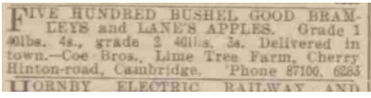
1950 - On the 1950 OS map below, we can now see that construction of the Walpole Road estate has taken place. The farm still has many of the original orchards that were purchased by George Coe in the late 1800's.
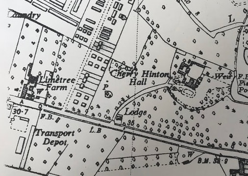
1950 OS, sheet XLVII NE 1:10000
Cyril Coe:
Cyril Coe 1928- 2006, lives at the farm his whole life. He marries Elieen Cooke, who had been previously married and had two daughters. Cyril and Elieen then ran the shop, which was at the front part of the main house, facing Cherry Hinton Road - the one us locals remember the most.
1964 The picture below comes from Mike Petty's Cambridge News archives and it is believed to show Mrs Elsie Coe, Cyril's mother, working in the shop at Lime Tree Farm.
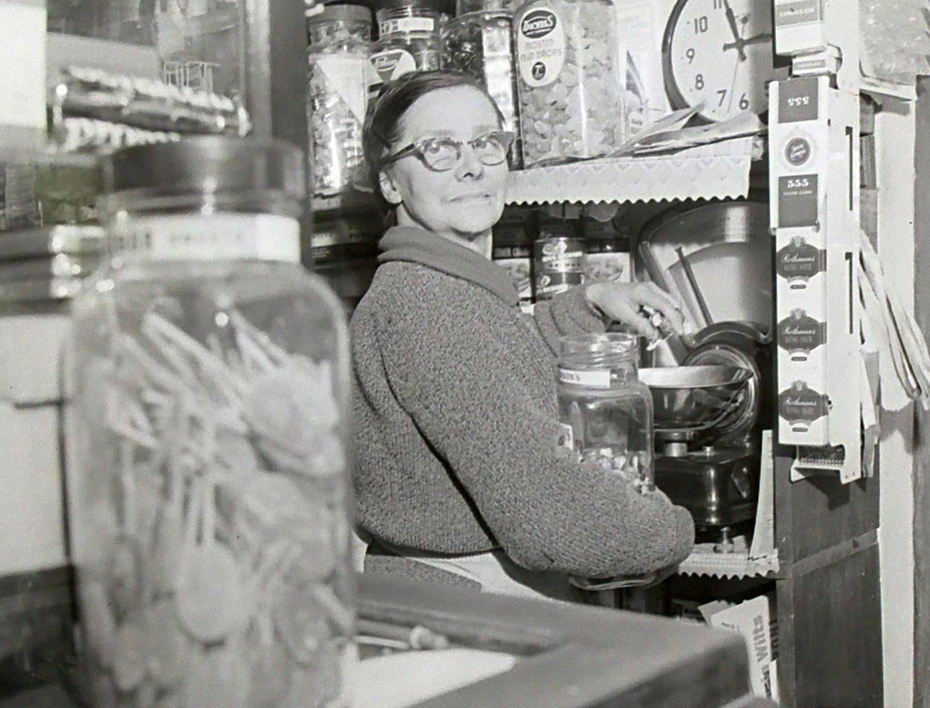
Elsie Coe, Cyril's mother, in the shop at Lime Tree Farm, 1963. (Mike Petty - E. Dimock, Cambridge News 1963, unpublished)
1964 - The aerial view of Lime Tree Farm from 1964 shows the farm in the bottom right, with Dewent Close beneath it and Walpole Road now built above it. You can see the site of the transport depot opposite the farm and the orchards continuing over the road in what was to become Netherhall School lower, front playing field.
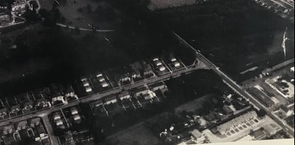
June 1964, view of Lime Tree Farm. (A1X 98 -Cambridge University Collection of Aerial Photographs)
1973 onwards...After Jessie's death, his wife, Cyril's mother, Elsie, stayed on at the farm with her son, his wife Elileen and the children. The orchard farming had ceased with the land being sold off and most of it becoming the Netherhall School lower, front playing field.
My uncle married one of Mrs Coe's daughters and as I only lived a little further down the road, on Cherry Hinton Road, I used to go and play with my aunts kids at Lime Tree Farm, where we would climb about in the old barns and hay lofts. I can remember being sent, by my mum, up the road, to go to the little shop to buy a tin of meatballs from Mrs Coe.
By the late 1990's Cyril and Eileen had moved out of the old farm house and had a new bungalow built for themselves next door. They then sold off the old house and the land behind which was once the farm. A new housing site was constructed and is named Coe's Court. Before long, all of the old barns and buildings had disappeared and with Cyril's death in 2006 and Elieen's death in 2009, the end of Lime Tree Farm and the Coe's at the site came to an end.
More pictures of Eileen and Cyril and the shop - coming soon
Cyril & Eileen Coe
I have started a public family tree for the Cherry Hinton Coe family on Ancestry, to provide further information and gather more records. You can view it here:
Coe Family Tree
I hope this has been of some interest and use, in particular to Cherry Hinton residents and anyone researching the Coe family tree. Every now and again, I'll come back to this and add, edit and adjust as I get new pieces of data and information. Perhaps, you may feel inspired to do a bit of research yourself, which would be brilliant! I've started listing a few things that could be looked at further, below. This is not extensive of course but just a few things, that are thoughts to follow up. Research is never done and always throws up more questions than answers :)
Further research to be done:
Where did the first Coe come from - Richard Coe, where was he born, what was his occupation etc? Which one of the Coe's first got into the market gardening business? Did they sell their produce at the Cambridge market? what about further afield? or were they wholesale suppliers? What fruits, vegetables and produce were they producing, other than those mentioned in the adverts above? Did any of the Coe's work at the Cherry Hinton Hall kitchen gardens and orchards, when John Okes was in residence (c.1835-1871) or afterwards (c.1930 - 1990) when the Council nursery was in operation at the back of the Hall, producing plants for the counties parks and roundabouts etc? Other that Lime Tree Farm, where else in the village were Coe's orchards and gardens, if any others? Did any descendants go off into other villages and towns, continuing the market gardening business, if so where and are any still running today? How many of Coe's descendants are still living in Cherry Hinton? How many of their original trees, from the old orchard plots, still remain in peoples gardens unrecognised for what they were part of? - couldn't resist having a little general look around for this one - all where plots 5 & 6 would have been and the original George Coe's orchards, shown on the 1883 sale map - see photo gallery below. There were a lot of much older cherry tree stock along with many apple trees and other cherry trees around - separating out what is modern garden planting, to what remains of any of the Coe's orchard stock and the descendant trees is a challenge that would need revisiting. Find out more about Frederick Coe born 1824, market gardener of Histon and see if there are any links to the Cherry Hinton Coe's and also to what eventually became Chiver's of Histon? Other pictures of the Coe family/Lime Tree Farm site.
Looking for old fruit tree stock, from Lime Tree Farm, that may remain today.
Below: Coe burials in St Andrew's Church Yard, Cherry Hinton. These are from the survey's and records which myself and Mr Clarke made in 2005.
Update on the Coe/Chivers connection - so, do you remember the Frederick Coe, mentioned in the newspaper article of 1894 above, who wasn't part of the Cherry Hinton Coe's but was a market gardener living in Histon? I had not only wondered if they was a link to the Cherry Hinton Coe family - still looking at that - but if there had been a link to Chivers of Histon, the famous fruit growers and jam makers...well, there is of sorts. Frederick Coe, his wife Susannah and their children live next door to Stephen Chivers, with his wife Rebbecca and their children - as shown on the 1861 census. The two families live north east of the green in Histon and Steven Chivers is a farmer and gardener of 140 acres, employing 9 men and 5 boys - it is Steven Chivers who starts the great Chivers enterprise. So they were at least neighbours, in dwelling and fields. In addition to this their family links go back a little further as Frederick's father, James Coe, also a gardener is living next door to John Chivers in 1832.
In addition to that the next thing I find out is that Frederick Coe takes a Thomas Chivers to court over damage of his market garden produce - see article below - so although it is not currently a connection in quite the way I'd imagined, it is still something worthy of note and interest. 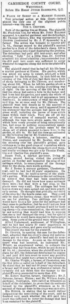
Cambridge Independent Press, September 1888 (BNA)
Although this strays a little from sticking to Cherry Hinton history, I couldn't resist sharing this with you too. The article below describes a tragic incident involving James Coe, Frederick Coe of Histon's father. It struck me how, not only did Frederick witness this incident, but how we had begun our discovery of him with a near fatal incident of his own, which must have reminded him of his fathers fate.
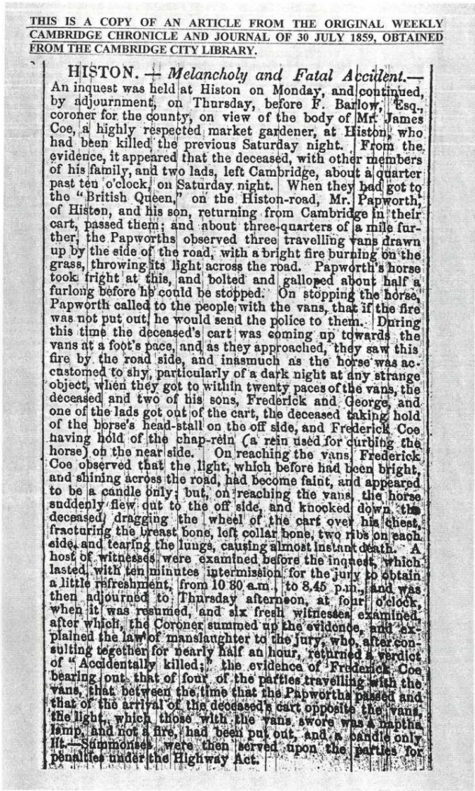
If you'd like to support the work that I do, why not buy me a coffee, I'd be really grateful and it will help keep me going :)
©Michelle Bullivant, May 2020
A little exploration into one of the old farms of Cherry Hinton. Ventress Farm was one of the old farms that stood in Cherry Hinton village, positioned just off of, what is now, Cherry Hinton Road. There would appear to be nothing remaining of it to see today...or is there?...
So as you can see from the two little video clips above, it may be that there is something of the old farm buildings remaining, that we can see today, hidden away from sight and only there if you go exploring and have a look. The question is, is that older looking house, within the more modern Ventress Farm Court Flats, actually the old Ventress farm house? or even on the site of the Ventress Farm. Given the name of the site today as Ventress Farm Court, it seems a fairly obvious clue that this was at the least the site of the old farm. So let's take a look at the things I can tell you about Ventress Farm, that I know of already and then see if we can decide if that house is, in fact the old farm house. Firstly lets get our position clearer in the landscape.
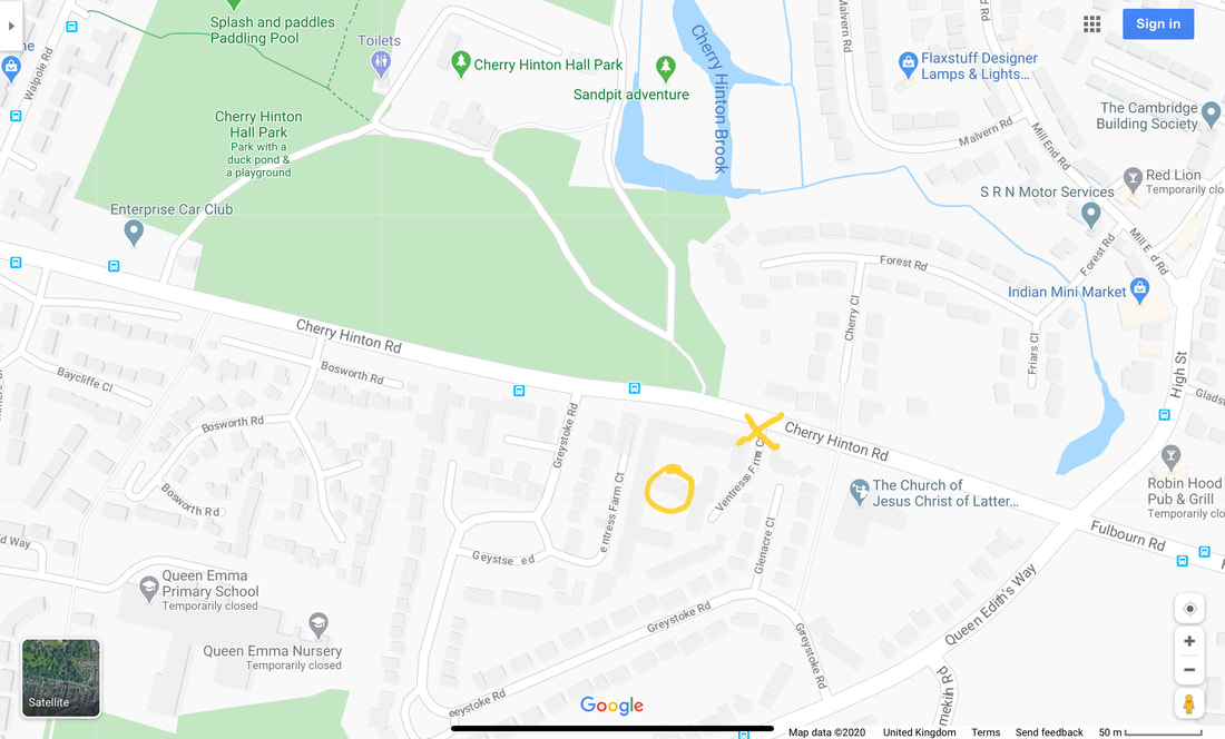
This is the southern end of Cherry Hinton. You can see the grounds of Cherry Hinton Hall top left and the blue pool is Giant's Grave, which is at the crossroads at the start of Cherry Hinton High Street, with the Robin Hood pub opposite bottom right corner. The yellow X marks the entrance to Ventress Farm Court and the start of video clip 1, the yellow circle marks the potential old Ventress Farm building in video clip 2.
A good place to start is the old Enclosure map of Cherry Hinton, which is from 1806, when Enclosure took place in Cherry Hinton (more on that in another blog coming soon). This is one of the earliest maps that we have for the village in any detail and we can get to see what buildings were there at that time.
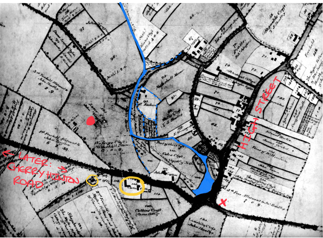
The Enclosure Map, 1806, of Cherry Hinton, showing the portion that we are examining. I have coloured in the Giant's Grave and the brook and marked two of the roads so that you might get your bearings. I have also put a red dot on the spot where Cherry Hinton Hall was to be built later, and a red X to mark where the Robin Hood pub now stands. I have circled in yellow the two sets of buildings on the road, around the area that Ventress Farm once stood.
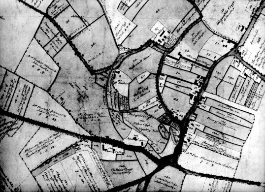
Here's the map unmarked for you. (Cambridgeshire Archives, Cherry Hinton Enclosure Map. Photograph M. Bullivant)
So in 1806, we can see that there are two sets of buildings around the site. The ones, in the larger yellow circle, look more like a set of related buildings which make them a more likely candidate for a farm and then the second singular building in the smaller yellow circle further to the left. Let's have a go at overlaying the modern map with the Enclosure map to see if we can sort the position out better.
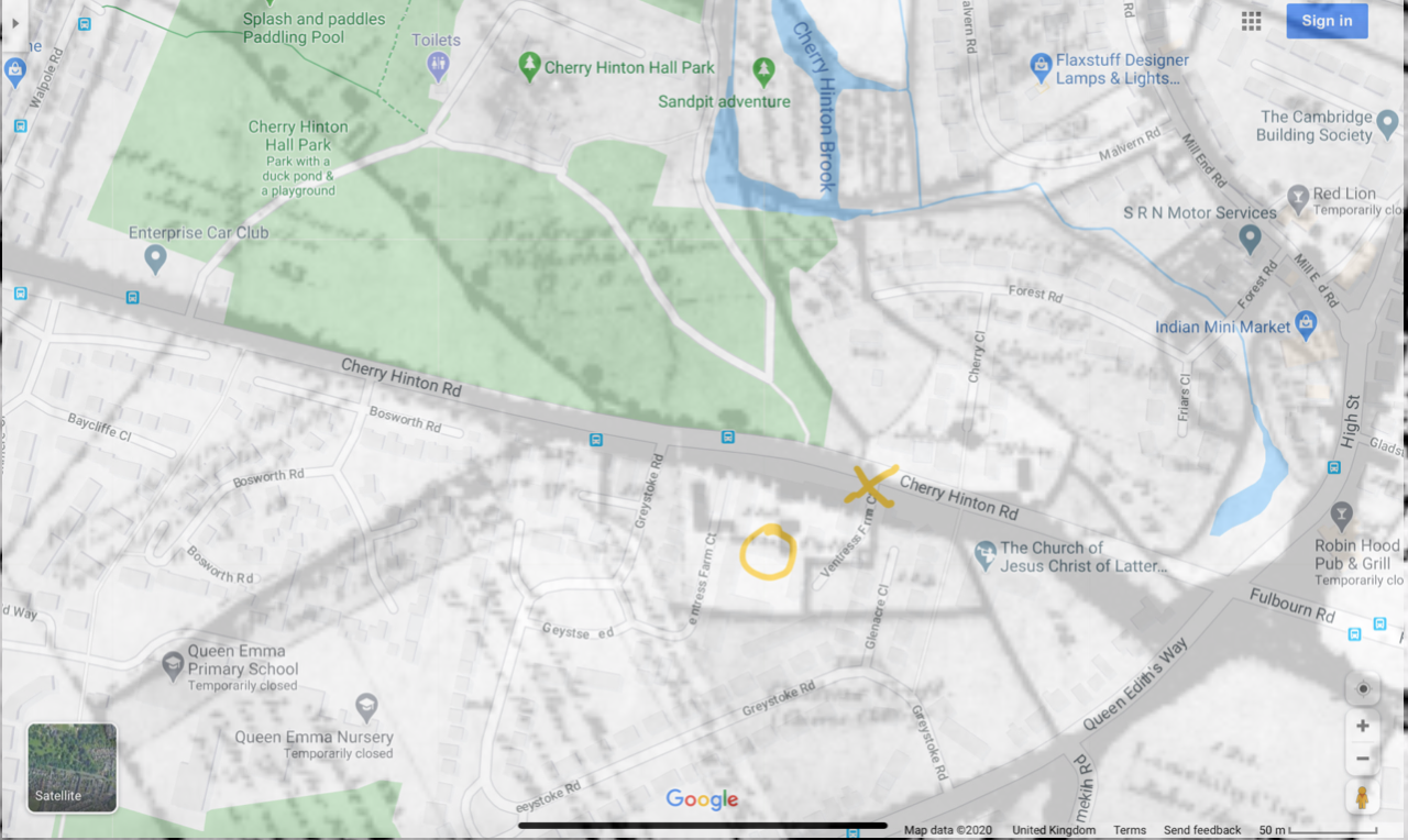
The modern map laid over the Enclosure map of 1806, to give you an approximation of the buildings that may be the building that we can still see today.
Hopefully you'll be able to make out a little of what is showing through the overlaid maps above. We can now rule out the building shown previously, in the smaller yellow circle, and turn our attention to the collection of buildings, within the plot of the larger yellow circle. As you can more or less make out in the overlaid maps above, the left hand L shaped building seems to lay beneath what is now a road way - (the second part of Ventress Farm Court roadway, which comes off of Greystoke Road). The building that is shown on the picture above, in the yellow circle above is the one to focus on. If it is not the building that remains today, it would have stood upon the same spot and may relate to those bricks that were reused to make the back wall, shown in video clip 2.
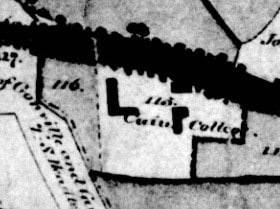
Close up of the buildings in our plot on the 1806 Enclosure map
As you can see there are two L shaped buildings within this one plot, numbered 113, and marked as owned by Caius College. In fact look a little closer within the plot and you'll see another small, square building, by the roadside. The dark line going across the picture is where Cherry Hinton Road now lays (this used to be called Long Drove). It does not name the site as Ventress Farm on this map. I need to do several things to make this information clearer at this stage but given the lockdown that we are in, some things will just have to wait until another day - one of which is a trip to Caius College to have a look in their archives, as it will be good to see what they have on Cherry Hinton in general but also to see what this site was called in previous years to the Enclosure. I also need to pop back up to Cambridge Archives, which is now in Ely, in its new building there, and go over both the Enclosure and accompanying pre-Enclosure maps of Cherry Hinton, getting some new and clearer pictures of them to share with you. I will then also be able to look through the Enclosure award book to see what and who else may be listed, for the plot that we are looking at. I do have all these records here but hidden in piles of archives, in boxes, so it's just as well to go and get some newer pictures with better camera. As I get more data I will keep adding to this post.
In the old medieval open field system within the parish of Cherry Hinton, the site lay in a large parcel of land called Fendon Field. The written survey, of parts of the village in 1592, by Christopher Saxton, describes many of the smaller parcels of land within Fendon Field, most of which are owned by Gilbert Wise and his family but it doesn’t mention any buildings, only the size of the land parcels. The same can be said for the survey of the land carried out in 1733 by John Tracey, some of the land within Fendon Field still being owned by the Wise family, descendants of Gilbert Wise.As we've just seen, on the Enclosure map of 1806 we can see that Gonville and Caius (Cambridge College) are marked as owning the site. Here's a little more information relating to that for now.
“In 1503 Thomas Willows granted c.45 acres to Gonville Hall (Cambridge), to which in 1708 W. Peters left 66 acres copyhold of Netherhall manor. After inclosure [1806] Caius College's main Hinton holdings were in Fendon field… Between 1830 and 1857 its land was leased out to William Ventris. Its lands were sold off piecemeal in the 20th century, and in 1998 it retained 20 acres....In account of Caius' building expenses between 1564 and 1573, amounting to £1,837, includes purchase of timber-trees from Warboys and Ramsey woods, freestone and rubble from Ramsey [Abbey] and Barnwell [Priory], freestone from King's Cliffe and Weldon, clunch from Haslingfield and Barrington and lime from Reach and Cherry Hinton.” “From the 16th century Caius College owned other lands in Teversham, called WILLOWES. In 1502 Thomas Willows, a Cambridge glover, had devised his purchased lands, c. 79 a., in Teversham, Fen Ditton, Fulbourn, and Cherry Hinton, to Gonville Hall, for 99 years, to help maintain a fellow and bible clerk. The Teversham portion, which, with other land in Fulbourn and Fen Ditton, became Willowes farm.” [in Teversham] (A History of the County of Cambridge and the Isle of Ely: Volume 10, Victoria County History, London, 2002.)
The next thing we can do is to take a quick look at the site from the air.
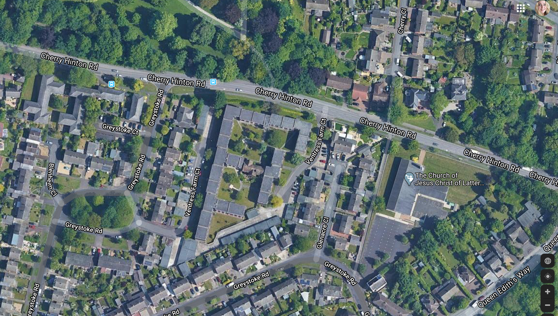
Can you see our current building?
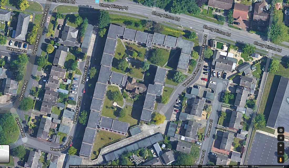
Zoomed in. Can you see it now? The older looking roof top in the middle of the modern roof tops of the flats in Ventress Farm Court.
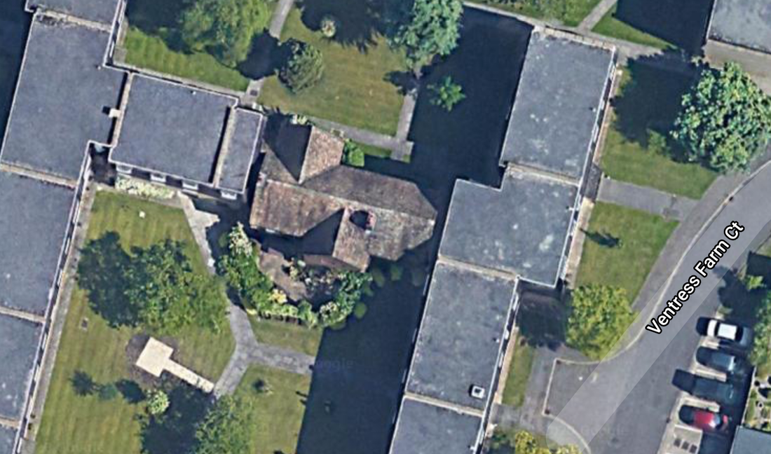
Last zoom in and now hopefully you can make out how old this building looks when seen from above - just look at that sitting there, right in the middle of the modern flats! Cool isn't it :)
So one last little thing to try before I start telling you about the tragic and interesting history from what I already know about Ventress Farm... let's overlay the Enclosure map with the aerial view to see just where that building lands, more or less ;)
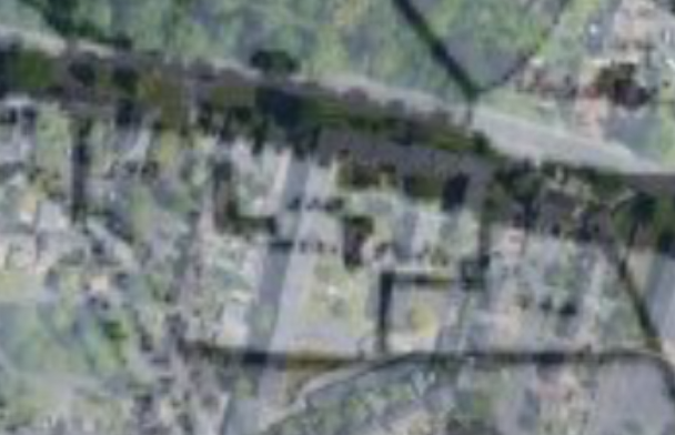
Here is the modern aerial overlaid onto the Enclosure map - not to clear to see really, is it? - here watch this next little video clip and then you'll be able to get your eye in better :)
Mr & Mrs Ventris lived and ran the farm on our site in the early 19th century, and it was called Ventris Farm - later, by the end of the 19th century the spelling had changed to Ventress. You can read more about the tragic incident that occurred, in 1813, to Mrs Ventris and her young child below:
The following is gleaned from old newspaper records about the Ventress (Ventris) family in Cherry Hinton and Ventress Farm:
Mrs Ventris, Relief of poor, May 1801 (Cherry Hinton Chronicle, E.Filby)
Relief of the poor in Cambridge and the neighbouring villages. Second subscription. Mrs Ventris, Cherry Hinton paid 10s 6d
Melancholy Event, September 24th 1813 (Cherry Hinton Chronicle, E.Filby)
We are much concerned in stating, that on Monday morning last, Mrs. Ventris, wife of Mr. Ventris of this place was found drowned in a ditch in the Parish of Cherry Hinton. She had left Cambridge on the preceding day, and took one of her children with her, a girl about 16 months old, who we regret to say, was also drowned, being found within a few feet of her mother. The Coroner's jury returned a verdict "found drowned".
This terrible thing happened and the verdict just seems so plain... 'Found drowned'. Perhaps it was as simple and as tragic as that. I presume that the ditch in question was most likely a point somewhere along the Hinton Brook, only across the road from Ventris Farm, which flows from Giant's Grave at the High Street crossroads, through the grounds of Cherry Hinton Hall and on towards Coldham's Common, before joining the River Cam at Stourbridge Common. You have to bear in mind that the Hinton Brook had far more depth and the area was covered in marshy boggy places, with natural springs and their little ditches cropping out in various places. This was before the drainage of the parish took place and before the water reservoirs were built on top of Lime Kiln Hill in the late 19th century, which in turn lessened the flow of water in the Hinton Brook. So perhaps it was just that, a tragic accident. It is natural to wonder if there was more to it such as foul play or even suicide, perhaps due to something like postnatal illness or such like but we can not presume or surmise anything like that because we do not have the full facts and can only give our respectful thoughts and prayers to the memory of Mrs Ventris, her young child and her family, acknowledging the sad incident, now part of our Cherry Hinton history.
I have started a family tree for the Ventris family, on Ancestry, so that I can get further records and information about them, which I'll add here as I discover facts.
Mrs Ventris was called Mary and she was buried, at Cherry Hinton, 23rd September 1813 (FHL Film No. 2149251)
The child, who died with her, was called Elizabeth Ventris, as she is shown as also being buried in Cherry Hinton on 23rd September 1813. (FHL Film no. 214251).
The gravestone of Thomas Ventris (possibly William's father) and the only Ventris gravestone I could find on my social distancing walk this afternoon, in St Andrew's Churchyard, Cherry Hinton. This little patch would have been the Ventris family grave area though. Back in around 2005, I, along with Graeme Clarke, surveyed the entire graveyard here and reproduced the grave plan and written grave records for the vicar at the time. I will dig that file out and check for more info on the Ventris family and put here later.
The main and only village burial site from the medieval period onwards was St Andrew's Church at the top end of the village in Church End - There was a large Saxon burial site further down Church End, pre-dating the main church today, which was discovered and excavated about 2009. Before that we've got isolated burials all over the place, from the skeletons of those massacred in long gone battles, found up on top of Lime Kiln Hill, at the War Ditches - to the boundary marker, bronze age burials around the parish and more besides. I'm not sure if the Baptist Chapel on Fisher Lane ever allowed any burials there but on the whole everyone was buried in St Andrew's Church yard - before the creation of the Cambridge Cemetery on Newmarket Road. I have long thought that there may have been some earlier, collective burial site, down the south end of the village (Mill End) somewhere, because Church End (in the north) and Mill End (south) were quite separate from one another before drainage took place in the late 1800's. Perhaps there is still a Saxon burial site to be discovered in Mill End somewhere - the only indication of something religious down that end at the moment, is an odd reference to "God's House" which keeps cropping up on old surveys and documents - it seems to lay somewhere off of the High Street, opposite the Post Office, in that area. So much to explore and discover still...:)
You can visit the tree that I have now started on Ancestry, to learn more about the Ventris family by clicking this link: www.ancestry.co.uk/family-tree/pt/RSVP.aspx?dat=MTY5MDQ0MzkwOzswMWU5NDJkNS0wMDA2LTAwMDAtMDAwMC0wMDAwMDAwMDAwMDA7MjAyMDA1MTIwNzE3MDI7MQ==&mac=KJIo8AoL8hQtxxf6g8vMBA==
The basics are: Mr Ventris was William Richmond Ventris and he married Mrs Ventris - Mary Lawrence in Cambridge on 28th December 1796 at Saint Andrew the Great Church. Mr Ventris was born around 1765 and his parents were from Teversham. He was married first to Martha Plume (born 1764 - died 1788) and they had 2 or 3 children together. He then married Mary and they had 4 or 5 children together. William and Mary had a baby called Sarah in June 1812 and who was then buried in Cherry Hinton in June 1812. Mary and her daughter Elizabeth died the in September 1813 - the newspaper article saying that Elizabeth was about 16 months old - I wonder if Sarah and Elizabeth had been twins? - a quick check of the records confirms this to be the case, as both Elizabeth and Sarah are baptised together in Cherry Hinton on 6th June 1812. William and Mary's son, Edward Ventris (b.1802 -d.1886) went on to live in Cambridge (3, Bateman Street, Cambridge) and was the Vicar of the parish church in Stow-Cum-Quy. William Ventris died in 1827.
More newspaper clips and information regarding Ventris Farm:
27th September and 4th October 1816 (Cherry Hinton Chronicle, E.Filby)
Parish of Cherry Hinton in the County of Cambridge Whereas the GAME within this Parish has been much destroyed by poachers and unqualified persons, and considerable damage done by persons sporting amongst standing crops and other acts of unsportsmanlike conduct, obliges us to adopt this mode of proceeding. We the undersigned being owners and occupiers of Lands within the said parish, do hereby give notice, that such persons found trespassing will be prosecuted, and qualified persons are requested not to sport. T.S. Headly, R. Johnson, R.Rickard, R.Emson, W.Capp, J.Barrance, R.Granger sen., R. Granger jun., J.Truslove, John Headly, John Green, W.R. Ventris, William Tagg, Thomas Hart, J.Clements, William Coe.
October 15th 1819 (Cherry Hinton Chronicle, E.Filby)
Furniture - Cherry Hinton To be sold by auction by Elliot Smith on the premises of Mrs Ventris, deceased, on Tuesday next the 19th October at 2 o'clock in the afternoon. Consisting of bedsteads and furnishings, beds and bedding, 8 day clock, a bureau, corner cupboard, kitchen utensils, hooks and various other articles. May be viewed morning of sale. Catelogues to be had at the Coach and Horses, Fulbourn, Red Lion, Cherry Hinton, and Elliot Smith.
January 1st 1822 (Cherry Hinton Chronicle, E.Filby)
Inquest On Friday last, an inquest was held before John Ingle Esq., one of the coroners for this County, on view of the body of Thomas Lane, servant at Mr. Ventris's farm, at Cherry Hinton. It appeared that the deceased, who had been unwell for some time, but not so much so as to prevent his going about his usual avocations, retired to bed after eating a hearty supper. In the night a person in the adjoining room was awoke by the cries of a lad, who slept with the deceased. He immediately got up and only arrived in time to see the poor fellow expire. Verdict, died by the visitation of God.
September 14th 1832 (Cherry Hinton Chronicle, E.Filby)
Theft On Sunday night last or early on the following morning, a post chaise was stolen from the premises of Mrs. Ventris of Cherry Hinton.
October 21st 1882 (Cherry Hinton Chronicle, E.Filby)
MILK! MILK! J.Barton will supply Daily pure MILK from the cow 8 pints for 1 shilling. Deliveries to all part of the Town. All orders received at Ventris Farm, Cherry Hinton.
Owners and occupiers of Ventris (Ventress) farm over the years:
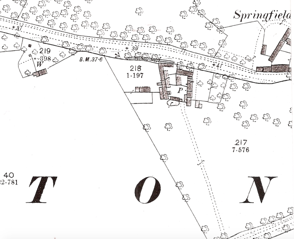
The 1888 Os Map (https://cherry-hinton.ccan.co.uk/content/catalogue_item/map-of-1888) showing Ventress Farm, as a collection of buildings in a square layout. P. indicates a pump and our building that stands today is upon the spot along the southside of this complex. Notice how the little building on the far left, which was shown on the 1806 Enclosure map, still stands.
Both the 1851 and 1861 Census do not record Ventris Farm by name but records a John Spencer as a farmer in the vicinity of where Ventris Farm would have been, on Cambridge Road (called Fulbourn Road 1861) - but we can not say for certainty that this is the same site, so for now we'll just note that, rather that say for definite.
In the news, which may relate to Ventris Farm, if Mr Spencer did indeed farm and live there, the following entry in the Cambridge Chronicle appears:
November 17th 1849 FIRE! On the night of Tuesday last, about 12 o'clock, a fire broke out in a wheat stack situate in a field on the farm of Mr. Spencer, of this parish. The flames speedily communicated to a contiguous wheat stack and a barley cob, and the three were reduced to ashes. The stacks were at some distance from the Homestead and there is no doubt that they were maliciously fired. The conflagration, from the solidity of the Stacks, lasted for a considerable period, and created a great deal of alarm in Cambridge. Mr Spencer is insured, but we have not heard an estimate of the loss, which must be considerable. (Cherry Hinton Chronicle, E.Filby)
Both the 1871 and 1881 Census do not record Ventris Farm by name but records a Remmington Pratt as a farmer in the vicinity of where Ventris Farm would have been, on Cambridge Road - but we can not say for certainty that this is the same site, so as with 1851 and 1861 previously, for now we'll just note that, rather that say for definite.
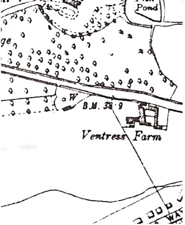
OS Map, 1950 (https://cherry-hinton.ccan.co.uk/content/catalogue_item/map-of-cherry-hinton-1950) - showing Ventress Farm buildings and still the other small building to the left, remains standing.
OS map 1885 shows the name spelt Ventress rather than Ventris.
On the 1891 Census, Ventris Farm isn't named but approximately where it would be expected a farm is listed but called Barton's Farm - perhaps a temporary change? this needs more investigation. As it corresponds to the site, it is worth mentioning the details here:
Barton's Farm - James Bass, Head, married, aged 60, Farm Bailiff, employed, born in Oxford Emma Bass, wife, aged 61, born Bucks William Bass, son, single, aged 37, Book Cavasser, born Bucks Louisa Bass, daughter, single, aged 23, born Trumpington Walter Bass, son, single, aged 19, Stationary Engine Driver, employed, born Trumpington *note how the son, Walter is a stationary engine driver - this suggests that he was working for the Pamplin family of Cherry Hinton who ran the steam plough works (where there were stationary engines working the plough) in the village and are recorded as owning the Ventris Farm site in 1913 - perhaps they owned it from this date, 1891
The 1901 Census doesn't name Ventris Farm, just the road, but we can presume with some degree of certainty that Daniel Coe who is shown as Farm Baliff and is on the 1911 Census (see below) as a Farm Steward, living at Ventris Farm, is at the same place in 1901.
So for 1901 it is likely that the following applies: Cambridge Road, Cherry Hinton - Daniel Coe, Head, married, aged 48, Farm Baliff, worker, born in Cherry Hinton Emma Coe (Emily on 1911 Census), wife, aged 47 years, born Cherry Hinton and Lizzie Coe (Lucy on 1911 Census), daughter, aged 20, Dressmaker, born in Cherry Hinton Ada F Coe, daughter, aged 16, born Cherry Hinton Any other the families shown either side of the Coe's on this Census could also be living on the site but without a link we can not presume to add them at this point.
In 1909 a sad incident took place at the farm:
Cambridge Independent Press, May 14, 1909 (British Newspaper Archive)
On the 1911 Census for Cherry Hinton, there are three people listed as living at Ventris (spelt the original way) Farm, as follows:
Obdiah John Malting, head of the household, aged 52, married for 30 years, 3 children born alive, 2 living, one died. Horse keeper, worker. born in Suffolk. Caroline Malting, wife, aged 51, born in Suffolk and Harry Joseph Malting, son, aged 20, single. Born in Suffolk. The house is listed as having 4 rooms (not inc. any scullery, landing, lobby, closet, bathroom nor warehouse, office or shop)
Also on the 1911 Census, shown living as separate family (and most likely building with in complex) at Ventris Farm were:
Daniel Coe, Head, aged 59, married for 40 years, Farm Steward, Farmer, Worker, born in Cherry Hinton. Emily Coe, wife, aged 59, 5 children born alive and 5 children living, born in Cherry Hinton. and Lucy Coe, daughter, aged 30, single, dressmaker, born in Cherry Hinton
c. 1913 - The two farms at Cherry Hinton owned by Pamplins were Ventris Farm and Sidney Farm. Ventris Farm stood on the left of Cherry Hinton Road as you left the Robin Hood public house and made your way towards Cambridge, the farmhouse stood on the site that is now a brand new housing complex of flats called Ventress Farm Court. (M. Bullivant, Cherry Hinton Community Archives (CCAN). You can read more about the Pamplin Bros. here - https://cherry-hinton.ccan.co.uk/wp-search/ventris)
Harold Ridgeon and his family are living at Ventress Farm in the 1960's - a well known Cambridge family, involved with the Sindalls Company, which had a site further down Cherry Hinton Road, opposite Wulfstan Way.
City of Cambridge Poll Book, 1960, (Cambridge Libraries and Archives)
The record on the Cambridgeshire Historic Environment Record database is as follows:
Which we now know isn't quite correct, the farm isn't completely demolished. So I have written to them to request the record now be updated with the new information provided by this post. You'd never know it was there, unless you live in Ventris Farm Court and saw that odd building in the middle as different, or if you didn't just come off road and explore because it can not been seen from the road side at all.
Addendum.
This welcome comment was posted to this article by Ivan who said the following: "Not sure if you found it already but if you search for planning reference C/75/0116 on the greater Cambridge planning portal, you find : "Address: Ventress Farm House Cherry Hinton Road Cambridge Cambridgeshire. Proposal: Erection of two-storey extention to existing dwelling to from flats.Change of use of existing dwelling to flats". Dated 02 Apr 1975. The application was granted - maybe this is as straightforward as it sounds - the house was there at that time and was converted to flats then?" If you go onto the planning portal yourself, you will find the information he is referring to and you'll see that it does indeed give the date for which the flats we see today at Ventress Farm were approved for construction in 1975 and that it also says they are to be extended from the farmhouse that stood on the site. It also suggests that the house itself is converted to flats. Here's a screen shot of part of the original application: 
Many thanks to Ivan for this information - and remember, if you have any information you'd like to add or ideas you want to suggest please do get in touch. In addition, you are more than welcome to share you memories of Ventress Farm and the site, living in the flats and so on, to this site - just drop me a line :)
If you'd like to support the work that I do, why not buy me a coffee, I'd be really grateful and it will help keep me going :)
|
|||