|
I have almost finished writing the full history of the Hopbine beer house and it will be ready to read here online shortly. It will be available as a free PDF booklet, which you'll be able to download using the link at the bottom of this article or by visiting the Downloads shop in the main menu above. In the meantime, I thought I would share with you some of the information and lovely old photographs showing rare glimpses of this long-forgotten Cherry Hinton beer house.
The Hopbine beer house (or Hopvine as it was sometimes known) once stood at the northern end of Cherry Hinton on the western side of the High Street, just south of Fernlea Close. Today nothing remains of the original buildings above ground and the site now lay beneath new houses since built on the High Street. It was in operation for about 100 years, from at least 1851 to the 1950s.
It was a beer house rather than a public house as the Beer Act of 1830 removed duty on beer and people were encouraged to run what were instead called beer houses for a licence fee, which was much cheaper than paying for a full licence to be a public house. This distinction between beer-only beer houses and fully licensed pubs selling beer, wine and spirits remained until around 1960. 
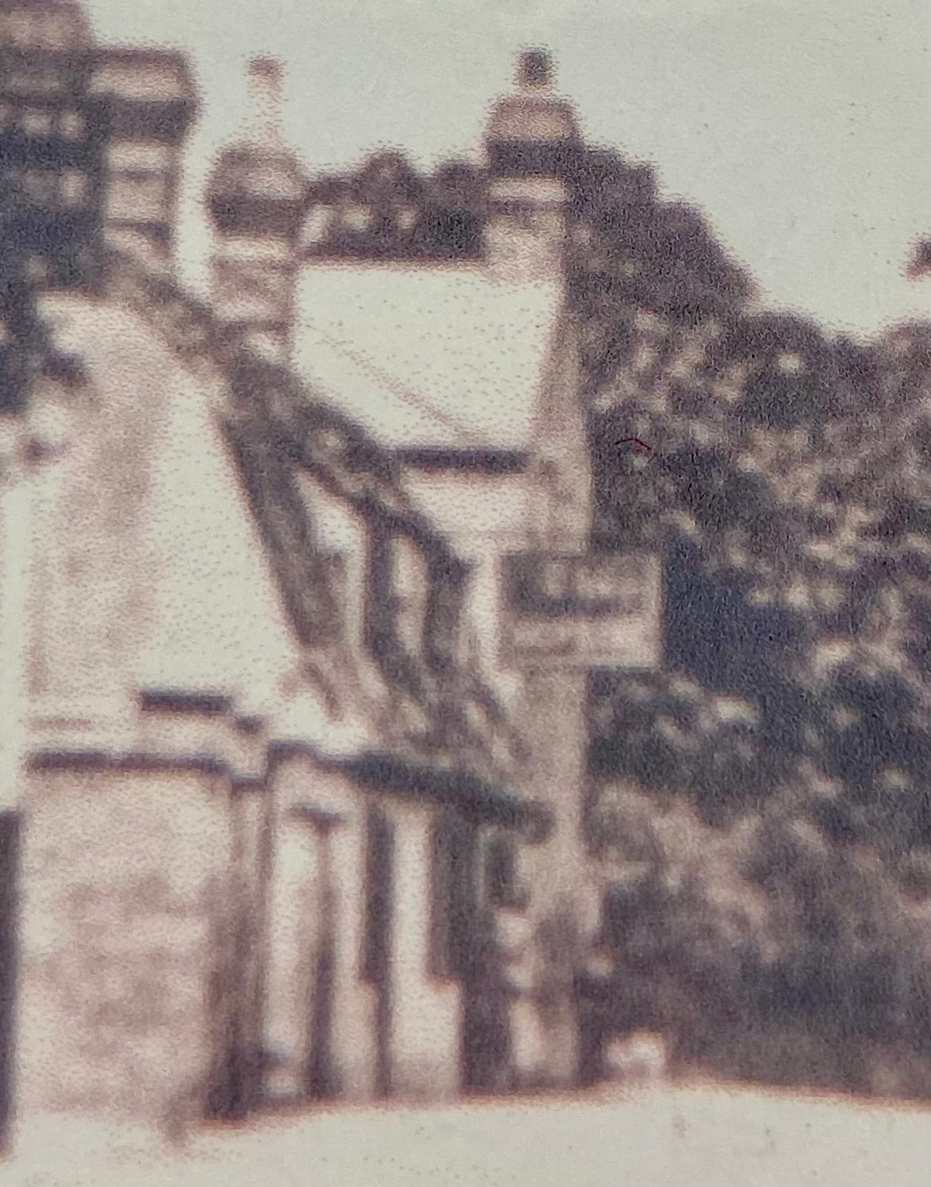
In the photograph below, you are on Cherry Hinton High Street, past the railway crossing, looking north towards St Andrew's Church - if you look carefully you will see, in the centre of the picture, left of the horse and cart, a wall with a short white vertical line on it - this is the old gas lamp sat on St Andrew's Church wall until earlier this year, before being damaged by vandals.
On the immediate left of the picture is an old thatched cottage which was called Robert's Cottage. Next to that was another house, bound by a fence, which can't be seen in this picture and then, set back from the road and again out of sight in this picture, was the original Five Bells public house - you can just make out the tall black and white post with the pub sign at the top. Beyond that are a row of cottages and you can just make out another sign hanging from these - this is the sign of the Hopbine beer house. 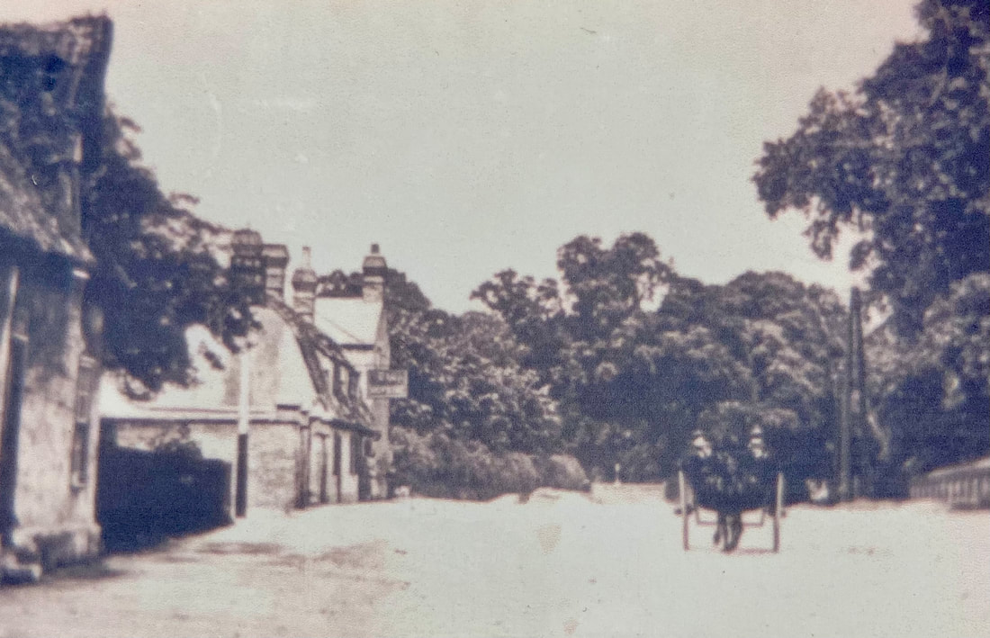
The sign of the Hopbine Beer House, High Street Cherry Hinton (courtesy of Cambridgeshire Collection)
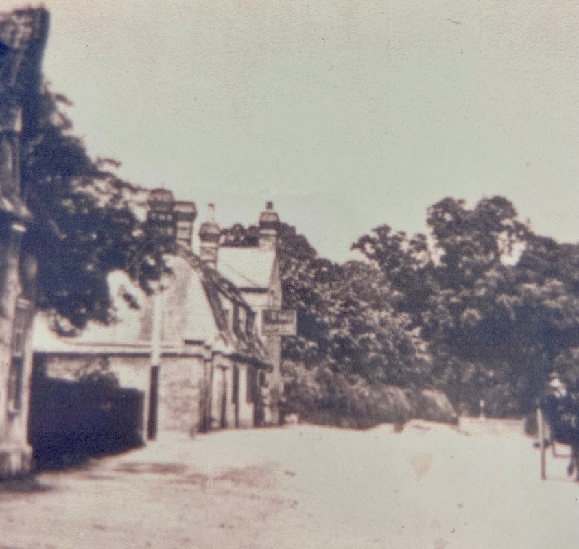
I have added it again below, enlarged twice for you - although we lose definition on the picture it is still good to take a closer look.
The photograph below is of a similar date of the one above -perhaps around c.1910 - again here you can make out the rectangle hanging sign which is attached to the cottage roof with an iron bracket. You can see what looks like a family standing outside the door to the Hopbine. You'll be able to read more about the people who owned and lived in the Hopbine and more about activities that took place there in the full history that I'll add here soon.

The Hopbine Beer House, High Street Cherry Hinton (courtesy Cambridgeshire Collection)
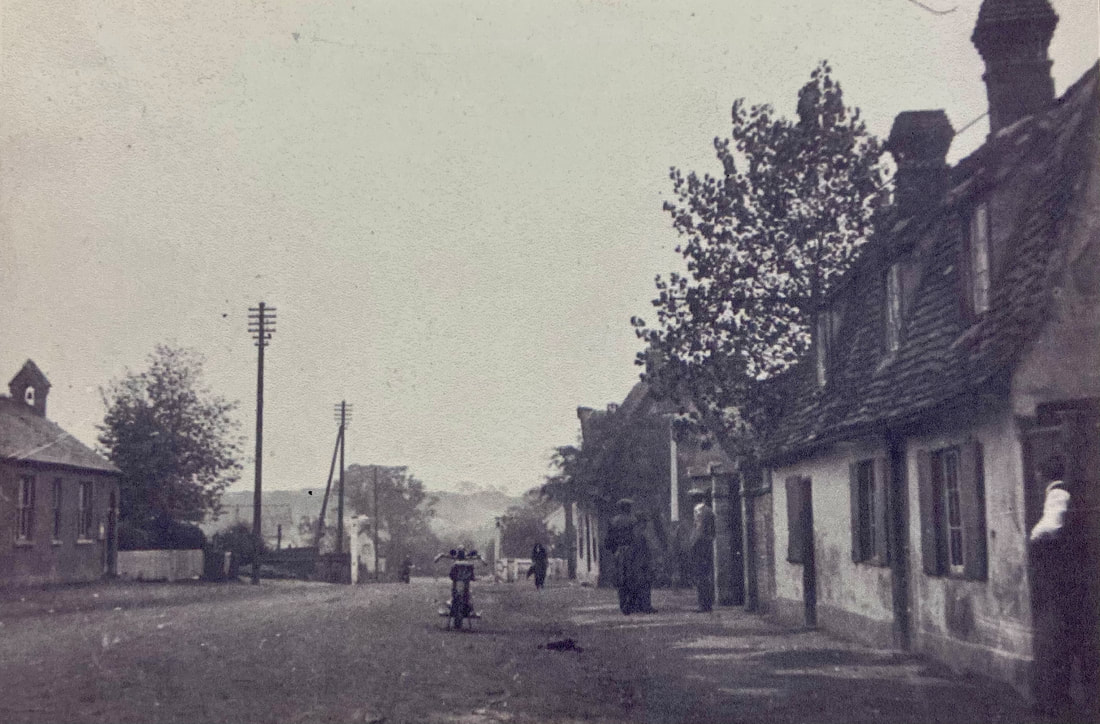
This next photograph below is from c.1927, and a little later on from the previous photographs but still looking from a slightly different angle, northwest, up the High Street. You can see Robert’s Cottage on the immediate left, the first house - this cottage, which District Nurse Harniman once lived in*, was demolished in 1966 to make way for the new Five Bells pub car park) and can now just catch a glimpse of the house we couldn't see previously, with its fence. Next along and set back from the road we can now see more of the original Five Bells pub with its pub sign followed by the row of cottages which include the Hopbine beer house/Quinney’s store with a man outside - this time it looks as though the Hopbine beer house sign has gone; this reflects the gradual change from beer house to grocery store. The house on the end is still shown as before and was Stanley Tabor's house, it stood at what is now the entrance to Fernlea Close. Beyond that, The Pamplin Brothers had their steam engine yard which then joined with Coldhams Lane (now houses).
(A separate history of the Five Bells Pub will be coming later this year. Along with a separate history of the Pamplin Brothers) 
c.1927 Robert's Cottages, The Five Bells and The Hopbine / Quinney's Store High Street Cherry Hinton. (Courtesy of Cambridgeshire Collection)
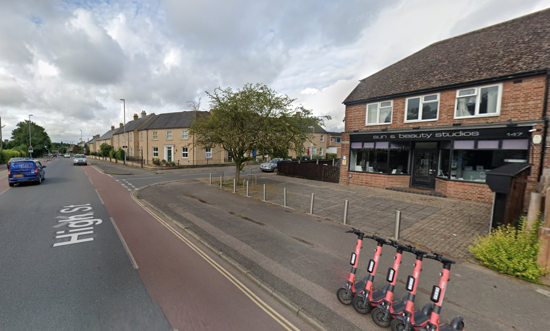
The Quinney family were the last family to run the beer house and began selling groceries and other items from the house. This was the very first version of the well-loved Quinney's shop, which after these buildings were pulled down, moved a little further south down the High Street to become Quinney's shop and newsagents in the house on the corner on Fernlea Close and the High Street (where Sun Studios are today).
It was Albert Frederick Quinney snr (born 1883 died 1960 aged 78) who was an ex-landlord of the Red Lion pub (1903-1908), - he was also a shopkeeper, butcher and grave digger* - who moved from the Red Lion into the old Hopbine and ran it as a shop, butchery and betting shop, amongst other things. He eventually had his new shop built on the north corner of Fernlea Close/High Street. His son Albert Frederick Quinney jnr (born 1904 died 1986 aged 82) took over from his father as shopkeeper but was no butcher*
The photograph below shows George Quinney (died 1961 aged 41) with Rover the dog*, outside his father's shop, the old Hopbine - you can still see the metal work bracket, which once held the beer house sign, still attached to the roof.
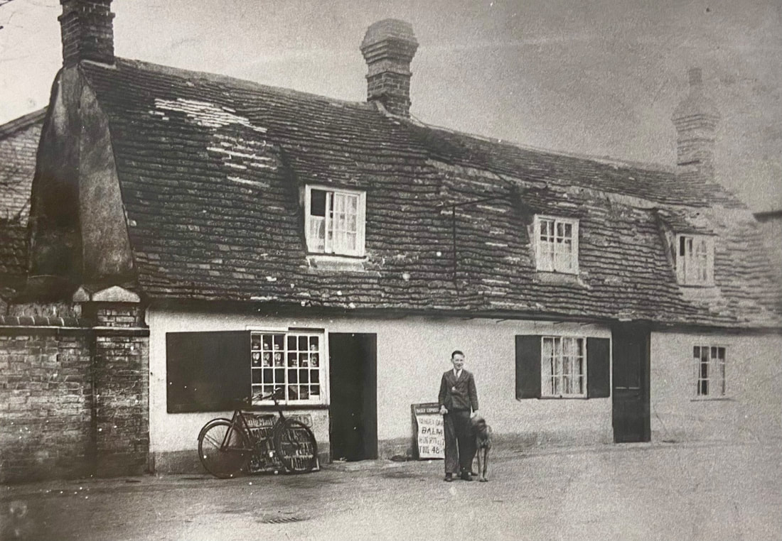
Quinney's first shop, the old Hopbine beer house (courtesy of Cambridgeshire Collection)
The photograph below shows a view looking in the opposite direction, south down Cherry Hinton High Street, with the Hopbine/Quinney's shop on the right side of the photograph. On the left-hand side, you can see the original Cherry Hinton School (where the school stands today on the High Street). The Gog Magog Hills can be seen in the distance and the railway crossing gates in the centre. To the extreme right-hand side you will see Stanley Tabor standing at a gateway at the end of the cottages.
View south down Cherry Hinton High Street (courtesy Cambridgeshire Collection)
The picture below shows the view towards where the Hopbine used to stand - approximately fronting the High Street where the brick wall is shown - The picture is c.1984 and shows the new Five Bells pub (cream building beyond the brick wall), the new road of Fernlea Close leading off of the High Street and Quinney's shop which he had built after the demolition of the Hopbine cottages. On the right, the houses with the black weatherboard are built on what was Pamplin's steam plough works meadow.
Below: The same view today
In the forthcoming full history of the Hopbine you will be able to see more pictures and a lot more detailed information, so do keep an eye out for that here, over the next month, and do follow me on the socials like Facebook and so on, to keep up with news of new releases on here as they happen.
* thanks to Richard Hoye archives held at Cambridgeshire Collection for these extra bits of useful information
You will be able to download a free PDF copy of the full 'History of The Hopbine Beer House, Cherry Hinton' here shortly.
Please feel free to get in touch if you would like to add anything to this story or if you have any further information on the Hopbine Beer House.
If you'd like to support my work and the archive, why not buy me a virtual coffee or make a one-off donation at PayPal, I'd be really grateful and it will help keep me going! Just click on either of the buttons below :)
0 Comments
Here you will find the complete contents of Cherry Hinton Memories Book Two - if you haven't done so already, I would encourage you to take a brief look at the introduction page about these books first - which you can do by clicking the link here: Cherry Hinton Memory Books - Introduction
There are three books altogether and one separately written story - you can find the links to the other books and story by visiting the Cherry Hinton Memory Books Introduction page, mentioned above, or by searching the index (Categories) on the righthand side of this page or by using the search box on the right.
BOOK TWO
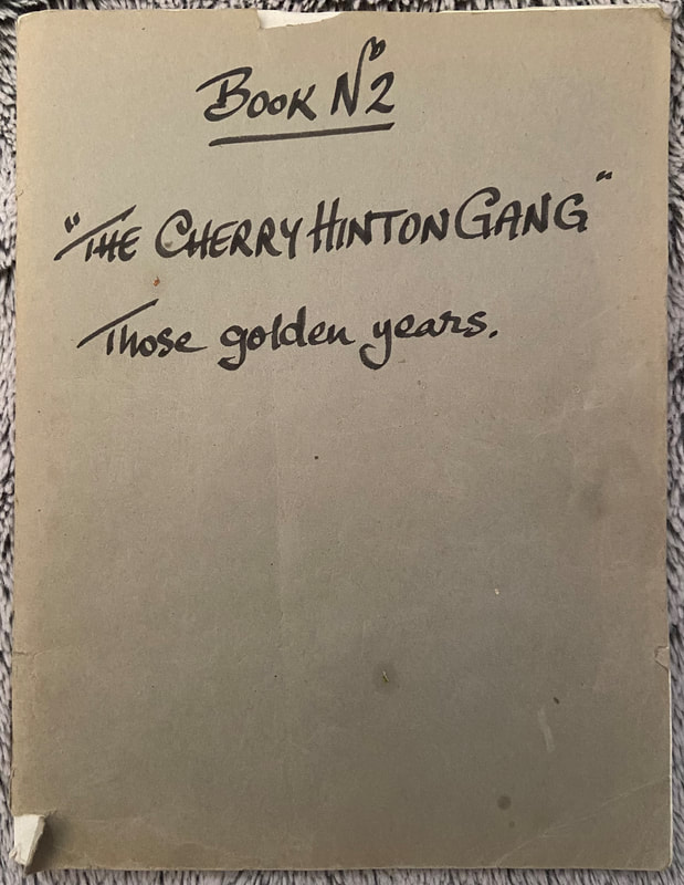
Book Two “The Cherry Hinton Gang” Those Golden Years
Contains memories from: Bryan Stevens June Stevens Pat Clarke Julie Smith
Below you will find the full transcription of book two, copied as it is, with pictures of the handwritten stories to compare (and send me any corrections!). You can choose to read through it here or, for more detail, you can click on one of the names above to see their story individually and any extra pictures that I have added to illustrate their story.
Book 2 “The Cherry Hinton Gangs” Those Golden Years.
Memories of Cherry Hinton by Bryan Stevens
Vic Phillips often mentions me by my nickname “Ziggy”. Ziggy was the owner of the clothes shop in Newmarket Road before he moved into Regent Street “Stylebest”. This shop sold the most modern clothing during the fifties and sixties and it was where I bought most of my clothing, hence the name “Ziggy”. Ziggy gave me a gold tie pin for my wedding in 1959 which I still have. I am now happily married for the second time. Bonfire nights in the High Street were something special. There was an air raid shelter opposite 197 High Street, where I used to live, and we would fill it up with logs collected from the Spinney. One Bonfire night the fire was so large that it nearly burnt down the telephone wires. There was a rubbish dump down Fulbourn Old Drift over the railway line and we would go up there with our air rifles to shoot the rats. One day we were up there shooting the rats when the siren sounded from Fulbourn Hospital and thinking someone had escaped we all ran home as fast as we could. We all talk about the Spinney with fond memories. During the school summer holidays we more or less lived up there, making dens, laying turf for the floor of the den, and cooking on open fires. One day when we were there my dog Gyp caught two rabbits from out of the chalk pits which I took home. Opposite the Robin Hood pub are the springs where the water for the brook starts. There used to be railings round the springs to try and keep us out but we would get in and try to catch the pike which would be by the island. We would stand on the now stepping stones and try to catch them before they went back to the lake in Cherry Hinton Hall. In the brook round by the Black Land allotments we would block up the tunnel underneath the bridge with a sheet of corrugated iron so that the water could not escape and we could get it deep enough to swim. Grandma Coe who used to live at the then 203 High Street was still riding her “sit up and beg” bike when she was 90 years old. I still remember when a horse and cart passed by her house and left “deposits”, she would rush out with a bucket and collect them. She always had the best roses in the High Street. As you old Hintonians know, my grandfather started the Stevens Brothers Building Company. He built some of the first houses for the Housing Association in Cambridge. One of the last houses they built was the bungalow in the High Street for the Bartram family (the level crossing keepers). They also built the shoe repairers bungalow next to the recreation ground. The Cherry Hinton History Society have no record of the building company. My only record is a photograph of a cast iron sewage drain cover in the front garden of the house in the High Street which used to be 201 High Street. It reads “Stevens Bros, Builders, Cherry Hinton”. If anyone could help me find out any other information I would be grateful. For the version of this story with pictures and added notes, please click HERE 
Bryan Stevens Cherry Hinton Memories
June Kathleen Stevens (nee Buffett) Cherry Hinton Memories
I was born on Friday 13th June 1930 at 39, High Street, Cherry Hinton in my grandmothers little thatched cottage which sadly no longer exists as all three were demolished to make way for shops. We were fortunate to have a general store and post office next door – Mansfield’s. Mr Mansfield was also our landlord. We had no gas, electricity or water in the cottage; cooking was done in the oven heated by the fire (which was never allowed to go out) or on a small paraffin stove. Water was collected in pails from the pump in the road outside Mansfield’s, in later days a tap was installed in the next door cottage garden. I don’t remember the name of the lady who lived there but the Fuller family lived in the one adjacent to grans. Fred Fuller spent many years driving what was called ‘the clunch waggon’ from the chalk pits up to the cement works, back and forth many times a day. The water carrying was a chore mostly carried out by the man of the house – in later years my boyfriend came in handy for the job! Grandad (Albert Buffett) was a road worker in his prime but after retirement I can remember him smoking his pipe, leaning on the gate at the top of the path and watching the world go by. The gate and railings were taken for the war effort but Grandad died in 1938 so didn’t miss them. At one time, he had an allotment round on ‘the black land’ and very productive it was. As a special treat, I was ferried there on the crossbar of his bike. Gran (Elizabeth Buffett, nee Clarke, whose father owned the bakery and store in Weston Colville) remained in the cottage for many years and I lived with her after we had relocated back to Cambridge from Norwich in 1946. My dad, Noel Eric Buffett, moved back to take over running the Self Motoring Garage on Hills Road. In his youth he was a milkman delivering by horse and dairy float in the village. This mode of transport soon became too slow, so he decided to be adventurous and started up a taxi service. I still have his first driving licence dated August 1922, he was 19! The service became quite popular, the local builders, Stevens Bros hired him every year to take them to Yarmouth for their day out at the races, I particularly know of this event as I am married to Bert Stevens’ second son Roger and the tales were told many times by Roger’s grandad. As teenagers we had a great time in dear old Cherry Hinton, the Rec being a favourite meeting place. The village had the usual celebrations at the Queen’s coronation, I Particularly remember the football match on the Rec – girls versus boys. I believe the girls won although we had a distinct advantage – the boys had their hands tied behind their backs! My good friend Joyce Elliot was a major player in our team and gave no quarter!! We also had the run of the Spinney, fishing for tiddlers down the ‘island’ opposite the Robin Hood and bike races down Lime Kiln Hill which would be very much frowned on by health and safety these days. How surprising that we al survived (Joey Ling did break his arm once!) Roger has just reminded me of when he played football in the field at the top of Fishers Lane – before the game, everyone was required to remove the cow pats! A wonderful ‘growing up’ time in Cherry Hinton, writing this has made me recall so many things, the book is a great idea, long may it continue. Regards to all who may remember me – June Kathleen Stevens (nee Buffett). 
June Stevens Cherry Hinton Memories
Pat Clarke Cherry Hinton Memories 3-9-12
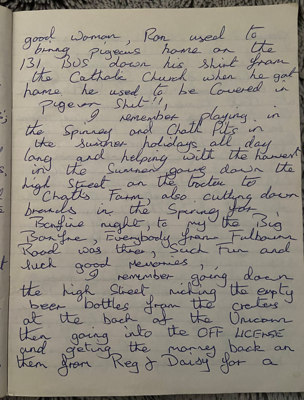
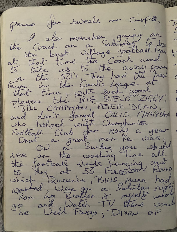
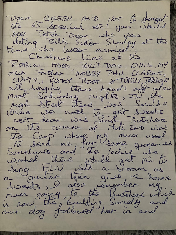
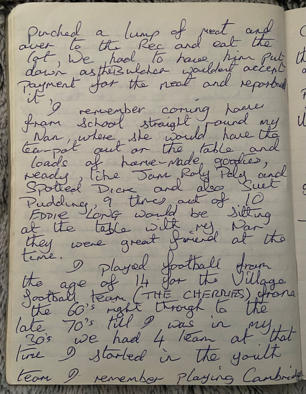
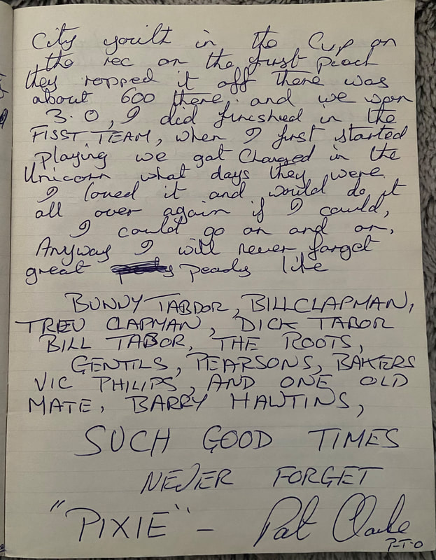
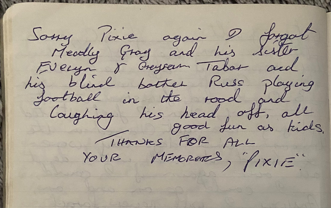
My memories as a kid in the 50’s & 60’s in Cherry Hinton, from Pat Clarke, nicknamed ‘Pixie’, from birth by: Ted Chapman, Dick Tabor & Bunny, when they first looked in my pram and saw my ears. I remember looking from my bedroom window, out over the hill at the fields to the Beech Woods from 62, Fulbourn Road which is not there now because they pulled it down to make way for the new houses, most families used to go to the Beech Woods in the summer for picnics and spend all day there. I also remember at Fulbourn Road, families having chickens and hens in their back gardens, also homing pigeons which Bill Chapman from 56 and my brother Ron had who was born at my nana’s house, 34 Fulbourn Road, my nan also took in Doug Kitson from a baby such a good women. Ron used to bring pigeons home on the 131 bus down his shirt from the Catholic Church when he got home he used to be covered in pigeon shit!! I remember playing in the Spinney and chalk pits in the summer holidays all day long, helping with the harvest in the summer, going down the High Street on the tractor to Chalk’s Farm, also cutting down branches in the spring for Bonfire Night. Everybody from Fulbourn Road was there, such fun and such good memories. I remember going down the High Street nicking the empty beer bottles from the crates at the back of the Unicorn then going into the Off Licence and getting the money back on them from Reg & Daisy for a pence for sweets or crisps. I also remember going on the coach on a Saturday to see the best village football team at that time. The coach used to take us to the away game. In the 50’s, they had the best team in the Cambs league at that time, with such good players like Big Stevo “Ziggy”, Bill Chapman, Peter Dean and don’t forget Ollie Chapman who helped with Cherry Hinton football club for many a year. What a great man he was. On a Sunday you would see on the washing line all the football shirts hanging out to dry at 56 Fulbourn Road which Queenie, Bill’s mum, had washed, where on a Saturday night, Ron my brother & myself would go and watch TV, there would be Well Fargo, Dixon of Dock Green and not to forget the 65 Special etc! You would see Peter Dean who was dating Bill’s sister Shirley at the time who later married. Christmas time at the Robin Hood Bill’s dad, Ollie my own father, “Nobby” Phil Clarke, Luffy, Rocky Root & Tubby Tabor all singing their heads off, also most Saturday nights, in the High Street, there was Smith’s where we used to get sweets. Next door was Parish Butchers on the corner of Mill End was Co-op where my mum used to send me for some groceries. Sometimes the ladies who worked there would get me to sing Elvis? With a broom as a guitar then give me some sweets. I also remember my mum going to the butchers which is now the Building Society and our dog followed her in and pinched a lump of meat and over to the Rec to eat the lot. We had to have him put down as the butcher wouldn’t accept payment for the meat and reported it. I remember coming home from school straight round my nan, where she would have the tea-pot out or on the table and loads of home-made goodies ready, like Jam Roly Poly and Spotted Dick and also Suet Pudding. 9 times out of 10, Eddie Long would be sitting at the table with my nan, they were great friends at the time. I played football from the age of 14 for the village football team (The Cherries) from the 60’s right through to the late 70’s till I was in my 30’s. We had 4 teams at the time I started in the youth team. I remember playing Cambridge City Youth in the Cup on the Rec on the first pitch they roped it off, there was about 600 there and we won 3. 0. I did finished in the First Team, when I first started playing we got changed in the Unicorn. What days there were, I loved it and would do it all over again if I could. I could go on and on. Anyway I will never forget great peachy life. Bunny Tabor, Bill Chapman, Trev Clapman, Dick Tabor, The Roots, Gentles, Pearsons, Bakers, Vic Phillips and one old mate, Barry Hawtins, Such good times, NEVER FORGET “Pixie” – Pat Clarke Sorry Pixie again, I forgot Meadly Gray and his sister Evelyn & Grayson Tabor and his blind brother Russ playing football in the road and laughing his head off, all good fun as kids. Thanks for all your memories, “Pixie” 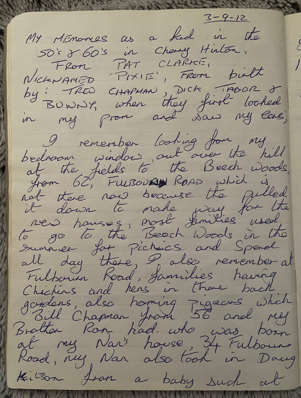
Julie L Smith (nee Plumb) Cherry Hinton Memories
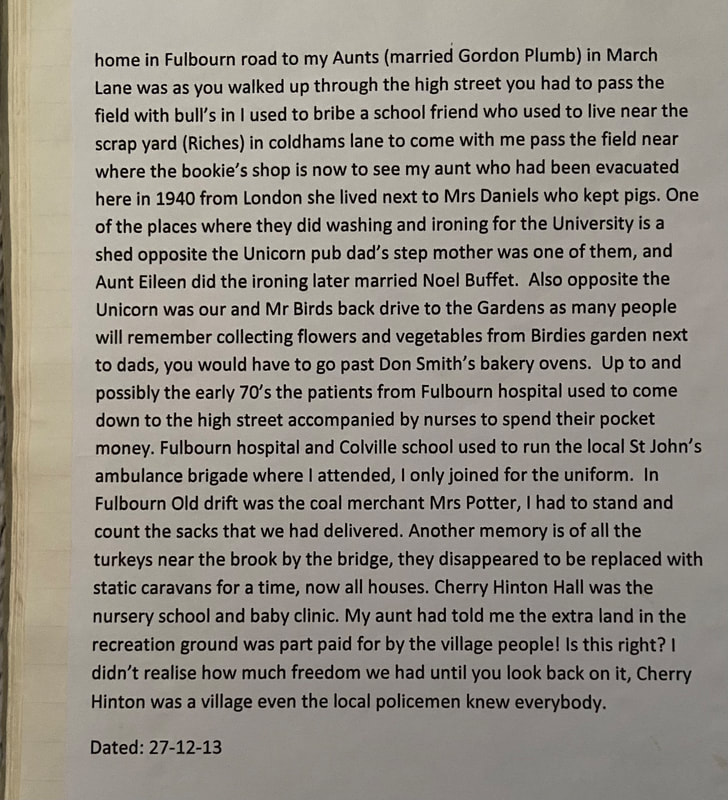
Formally Fulbourn Road (4 doors up from the Robin Hood and Little John) The stories so far have triggered a lot of my memories and stories from my dad about Cherry Hinton who all of his family were CH people. Dad, Len Plumb or as everyone knew him ‘Doggy’, as he always had a dog, somebody in one of the previous stories mentioned horses in the High Street, well dad used to bring the working horses down to wash them down in the spring near the Robin Hood and Little John the would mount one and gallop at speed with 6 more tied up behind the High Street, he often got told off for this, he then lived in one of the houses next to the level crossing with 2 brothers and 4 sisters, so there will be a lot of stories lost. Dads regiment was billeted back to Scotland were I was born and then we moved back to CH just after the war at the end of 1945, so my own memories start from here, my thoughts are triggered by many of the names of previous writers. We lived in Fulbourn Road before it was straightened, our front garden went up to where the car park on the other side of the road is now, and before traffic lights were positioned. I with Richard Tabor and Trevor Chapman and others “whose names are often mentioned in previous notes” would be always in the Spinney and chalk pits looking for meteorites, then we’d speed down the road on carts made up from old prams and end up in the Robin Hood next to the big stone that according to us had Little Johns footprint on it “traffic what traffic”. School like many others was in the Green Hut with teacher Miss Rush and Mr Reed who gave me the slipper, many years later he came into the hairdressers that I had just started work and said to everybody “I gave Julie here the slipper”. I digress. Back to better memories, can anybody else remember the day cattle got out of the train that had stopped at the crossing, they came charging down the road, can’t remember the date but we were in school. My family now cannot understand how we would sit on the church wall collecting car numbers and collecting the confetti. One of my walks from home in Fulbourn Road, to my aunts (married Gordon Plumb) in March Lane, was as you walked up the High Street you had to pass field with bull’s in, I used to bribe a school friend who used to live near the scrap yard (Richies) in Coldhams Lane, to come with me pass the field near where the bookie’s shop is now, to see my aunt who had been evacuated here in 1940 from London. She lived next to Mrs Daniels who kept pigs. One of the places where they did washing and ironing for the University is a shed opposite the Unicorn pub, dad’s step mother was one of them, and aunt Eileen did the ironing, later married Noel Buffett. Also, opposite the Unicorn was our and Mr Birds back drive to the Gardens, as many people will remember collecting flowers and vegetables from Birdies garden next to dads, you would have to go past Don Smith’s bakery ovens. Up to and possibly the early 70’s the patients from Fulbourn Hospital used to come down the High Street, accompanied by nurses to spend their pocket money. Fulbourn Hospital and Colville School used to run the local St John’s Ambulance Brigade where I attended, I only joined for the uniform. In Fulbourn Old Drift was the coal merchant, Mrs Potter, I had to stand and count the sacks that we had delivered. Another memory is of all the turkeys near the brook by the bridge, they disappeared to be replaced with static caravans for a time, now all houses. Cherry Hinton Hall was the nursery school and baby clinic. My aunt told me the extra land in the Recreation Ground was part paid for by the village people! Is this right? I didn’t realise how much freedom we had until you look back on it. Cherry Hinton was a village, even the local policemen knew everybody. Dated: 27-12-13 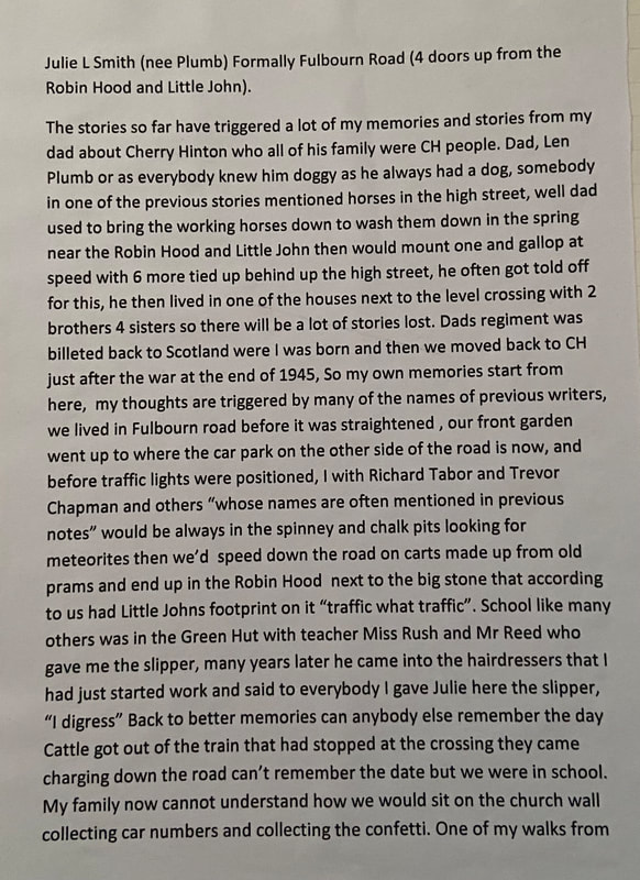
If you'd like to support the work that I do and the archive, why not buy me a virtual coffee, I'd be really grateful and it will help keep me going!
Just click on the green button below :) 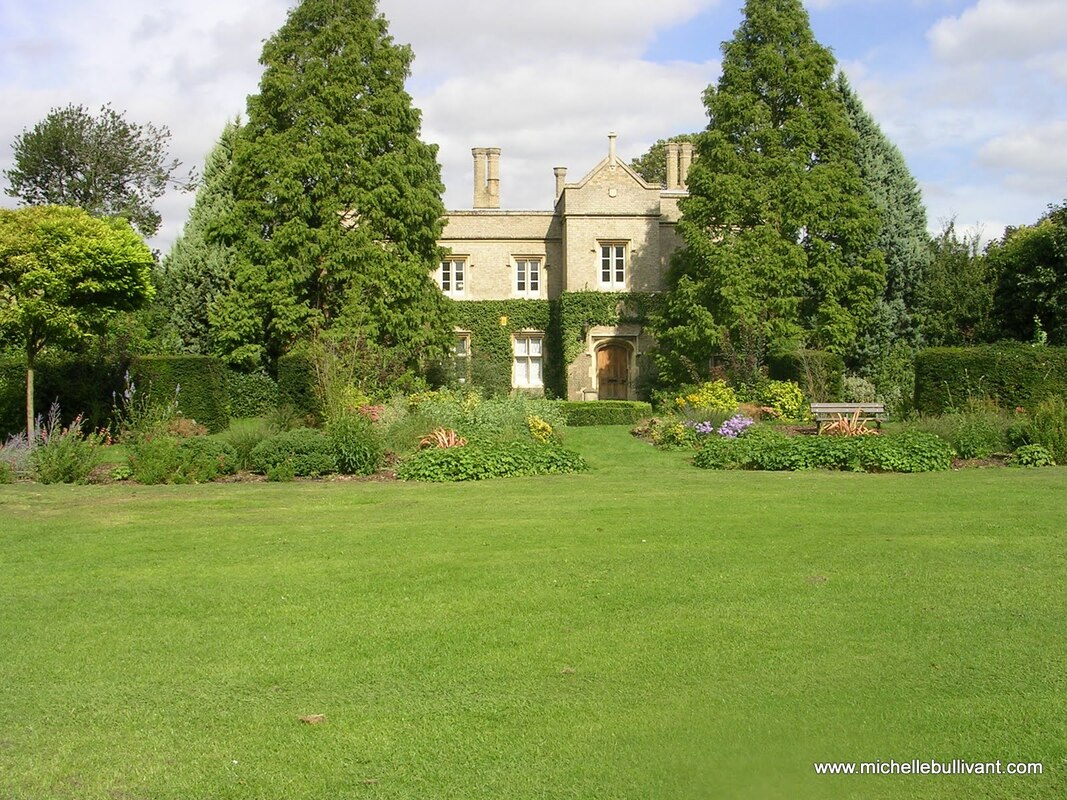
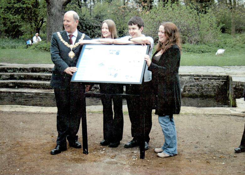
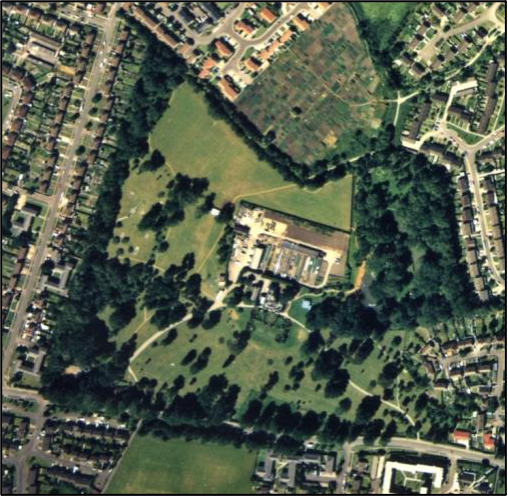
I thought that I would share with you this history of Cherry Hinton Hall, which I have been working on, for some years on and off, this latest version, given below, is based the one that I placed in the appendix of the Cherry Hinton Hall Management Plan, which I wrote for Cambridge City Council in 2019. It was used as part of the application for a Green Flag for Cherry Hinton Hall, which was a successful application with a Green Flag being awarded for the park (I will place a separate blog post about this on here shortly).
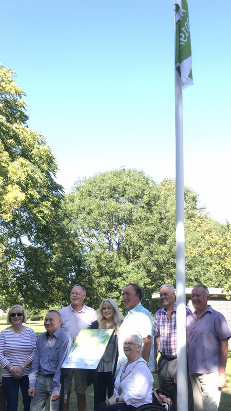
Cherry Hinton Hall getting awarded its Green Flag 2019
I am the official historian for Cherry Hinton Hall and grew up just down the road from "the Hall" as many of us called it. I went to the playgroup in the Hall building and to the clinic, again within the Hall building, for my childhood jabs. I also spent many hours playing on the park, at the duck ponds and within the grounds.
I am writing a book about the site which will give the full history, in more detail, and I will let you know when this will be available (I've been saying this for years, I know!). For now, here is a pretty decent length overview for you to have a look at.
Cherry Hinton Hall is a former Victorian country house and grounds. It was built, and the grounds laid out, in the late 1830’s by John Okes, a Cambridge surgeon, as his family home. Previous to the site being developed for this use, the area it was to be built upon, was part of the medieval open field system of the village of Cherry Hinton. There are very few surviving maps of this area before 1806. We can see the pre-Enclosure map and the Parliamentary Enclosure maps of 1806. These both show the dramatic transition from the medieval open field system, upon which, the village agricultural system used to function, to the changes to agriculture and the landscape, brought about by the Parliamentary Enclosure Acts. Through which process, the opportunity was provided to wealthy investors to purchase large parcels of land, which in this case, resulted in the land for the site of Cherry Hinton Hall to be acquired. From the time the Hall and Park were constructed and laid out, the site has remained relatively intact with its transition from a Victorian, family country home to its present form, as a multifunctioning, well managed public park.
The pre-Enclosure map shows that the area in which Cherry Hinton Hall was to be built, was within one of the 6 remaining open fields of the parish, these fields formed the medieval, agricultural, open field system of the village of Cherry Hinton. The site lay within the field, to the south west of the village, called ‘Bridge Field’ and through that field, the Hinton Brook flowed from the south-eastern side of the site. From the pre-Enclosure map, we can also see that there was a building called ‘Pecks Homestead’, which would have stood just south-west of where the present-day Hall building now stands. Within the ‘lake’ area by the waterways, at the north west of the site, there once stood several other buildings, which at the time of Enclosure, were in the occupation of Robert Rickards, who was the common herdsman of the village. These buildings are thought to be that of much older buildings, likely watermills and their associated dwellings, which have stood on the site since at least the 13th century[1].
[1] Cherry Hinton Hall 2004 Historical Research & Excavation Report, Bullivant & Clarke 2004
The 1806 Pre-Enclosure map of Bridge Field, Cherry Hinton. Showing the area that was to become the site for Cherry Hinton Hall & its parks and gardens. The red dot, added, shows where the future building of the Hall would stand. The blue lines show the water course and what was to become the ‘lake’ area of Cherry Hinton Hall.
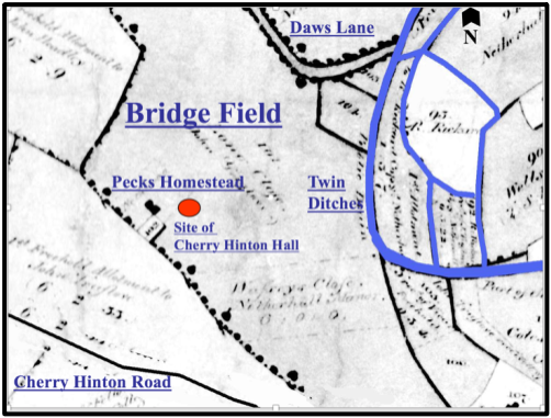
Courtesy of Cambridgeshire Archives & M.Bullivant
We can also see the waterways of the site from the pre-Enclosure map above. The square, water-enclosed island in the south west corner, may have been a medieval, moated manor site and is currently thought (M. Bullivant) to have been the site of Netherhall Manor, which was one of the 4 known but now gone, manors of Cherry Hinton[2].
[2] Cherry Hinton Hall 2004 Historical Research & Excavation Report, Bullivant & Clarke 2004
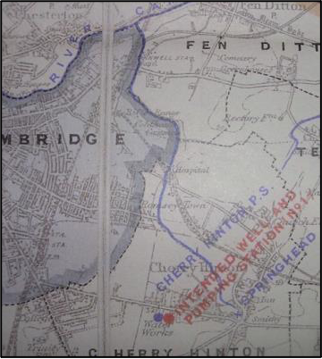
The Hinton Brook, which runs through the site, was an important tributary of the River Cam, where it joined its destination at Stourbridge Common in Cambridge. The Brook broke forth as a series of fresh water springs at the north-west base of the Gog Magog Hills and formed a spring pool, known locally as Spring Head (also known as Giant’s Grave). The Spring Head was no doubt a major factor in the siting of the village. From the Spring Head, the chalk lined, fresh water brook, flowed in a north-westerly direction, where it entered Bridge Field, to be manipulated for early industrial purpose, before flowing on north-westerly to eventually join the River Cam.
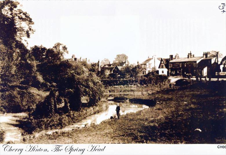
Courtesy Cambridgeshire Collection
Cherry Hinton Spring Head (aka Giants Grave) c.1910
Once the Parliamentary Enclosure had taken place, in 1806 in Cherry Hinton, much of the land ownership and use changed dramatically. The old, large, open fields and those systems of agriculture were gone. The land was divided up and sold into smaller parcels and new owners took over. Robert Rickards, the common herdsman living in Bridge Field, for example, was given notice to quit the property and land in 1814 and had to leave his home. These changes ultimately led to the purchasing of the land in Bridge Field and surrounding parcels of land by Mr John Okes, who planned and executed the building of Cherry Hinton Hall and the layout of its grounds. This new development work included clearing the old buildings that stood within the lake area of the site and once occupied by Robert Rickards and clearing the site of Pecks Homestead, all in preparation for the building of the Hall and park design, which began in 1831.
Courtesy of Cambridgeshire Archives.
The 1806 Enclosure map of Cherry Hinton, showing what was Bridge Field.
John Okes had returned from the army in India and joined his father, Thomas Verny Okes, a well-known surgeon, at Addenbrooke’s Hospital, to work as a surgeon at the hospital himself. At this time Addenbrooke’s Hospital was on the Trumpington Road site, within the town of Cambridge. Cherry Hinton Hall was completed by 1839 and John Okes had laid out his ‘miniature park and gardens’ around the Hall building. The site was just 3 miles from the Cambridge town and the Old Addenbrooke’s Hospital. It provided a perfect family home for John, his wife Mary and their children, an escape from the busy town, which lay just within the bounds of the countryside.
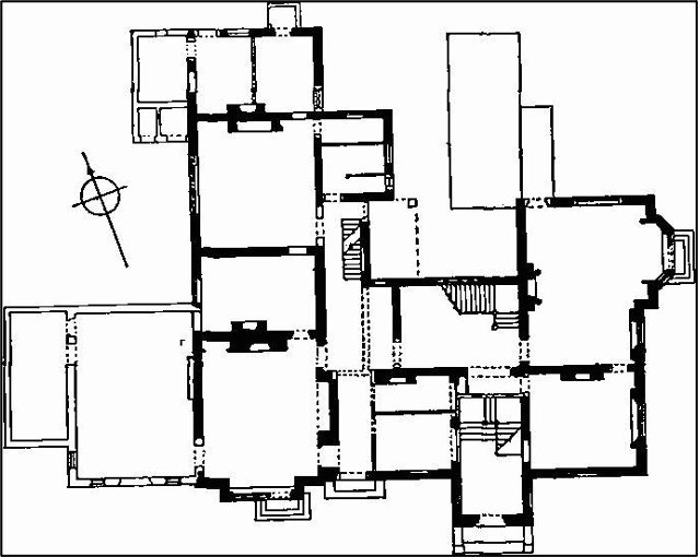
Courtesy M Bullivant
Plan of Cherry Hinton Hall c.1960 , shows the various additions (shown in light tone) to the original form (shown in heavy tone). The additions include the billiard room to the north-west side and various minor additions to the rear. You will see that there was once a staircase added, within the main entrance porch, which is no longer there today.
Cherry Hinton Hall was built in the Gothic Revival style. It was placed centrally within the grounds. Built in Gault brick with stone dressing, with stone and slate covered roofs. The chimneystacks have separate octagonal shafts with oversailing brick capping. The glazing was lead-traced lozenge-shaped panes. The coach-house and stables were built just to the north west of the main building and the small Lodge was built in the same style as the house, to the south-west of the main Hall building, by the entrance gates and entrance to the driveway. The Lodge originally had its own length of garden, which ran to the eastern side of the property. The park and gardens were laid out with meadow and pasture, along with formal garden areas at the very front of the building, a kitchen garden to the rear of the property and features such as the orchard that lay within the lake area upon the place where Robert Rickards had once lived.
John Okes had the water course, flowing through his land, enlarged at one point to make an small ornamental lake and stocked the stream with trout and had a pike pond made. He also spent a considerable amount of money in planting the grounds. He had four weirs built along the watercourse to help control the water and a special deal was agreed with Cambridge University and Town Waterworks Company (CUTWC), of which John Okes’ brother Richard Okes was a Director, to supply a specific gallonage of water to the lake and stream at Cherry Hinton Hall, as the CUTWC had also acquired land in Cherry Hinton, specifically bought to begin taking advantage of the natural spring water that flowed out the chalk hills just to the south-east. This eventually resulted in the action of building reservoirs on top of Lime Kiln Hill, close by Cherry Hinton Hall and would have a drastic effect on the flow of water into the site, so specific plans were made and the design and control of the waterway running through the hall was managed in order to please both parties.
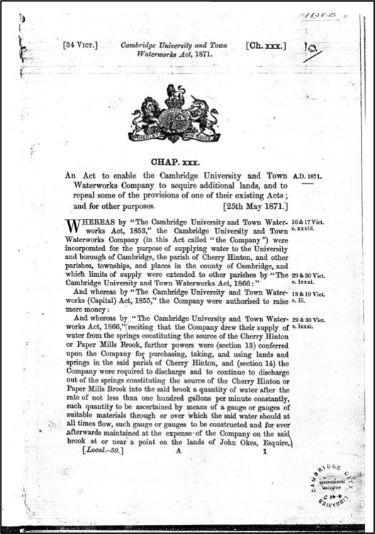
Courtesy of the Cambridgeshire Collection
Front-piece of the Cambridge University and Town Waterworks Act 1871.
Courtesy of the Cambridge Water Company
Cambridge University and Town Waterworks Company waterworks map.
© M. Bullivant
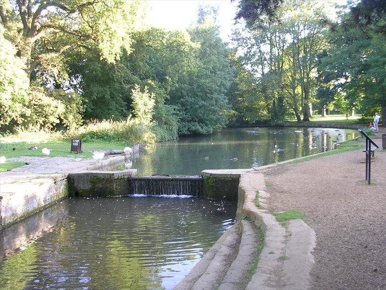
The lake area of Cherry Hinton Hall (the duck pond and early paddling area) showing the Hinton Brook flowing through towards us, and showing one of the four weirs that John Okes had built during the Victorian period.
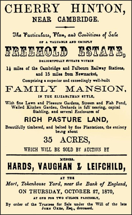
The planting of the varied selection of important trees adds to the historical value of the park. A combination of natural countrified meadows and paddocks with a mixture of formal gardens. From the sale particulars of the site in 1870, it can be seen that the grounds included a loose avenue from the gate lodge to the Hall, with the driveway forming a turning area on the Hall’s south side, outside of the front door entrance. Other parkland features included a kitchen garden, lawn and flower parterres, shrubberies and a fernery, two orchards, ornamental pleasure grounds, park-like paddocks, stream and fish pond, fine lawn, beautifully timbered and belted by fine plantations all set within about 35 acres.
John Okes died in 1870 and Cherry Hinton Hall and grounds were placed on the market for sale. The layout of the site, as he had intended it, can be seen from the sale map and particulars of the site. The sweeping driveway which ran from the south west of the site and curved round to the north east to meet at the front door of the hall was laid out when the grounds were planned, and remains, in its original position to this day.
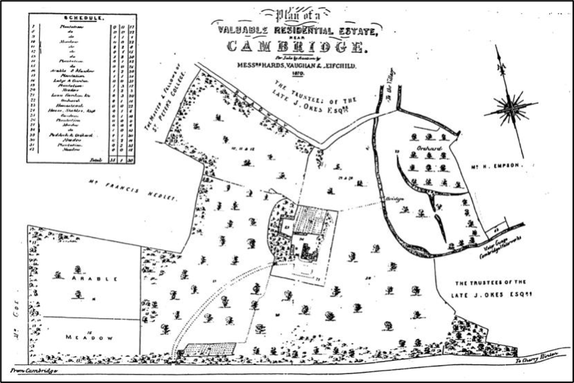
Courtesy of the Cambridgeshire Collection
Cherry Hinton Hall sale map, 1870. This map shows the detail of the grounds and features therein.
Courtesy of the Cambridgeshire Collection
The sale advert for Cherry Hinton Hall 1870.
Following the death of John Okes, the site was sold to Cambridge University and Town Waterworks Company (CUTWC) for the sum of £5000, who went on rent the property and its grounds to private tenants. Cherry Hinton Hall remained in private occupation for around the next 60 years. During this time various people lived at the Hall.
The first tenant after the death of John Okes was Charles Balls. Charles Balls had started out life working as a shoemaker and then went on to become a Mayor of Cambridge and later a Director of The Cambridge University & Town Waterworks Company. He, his wife and four of his daughters lived at the Hall. His wife Eliza died in 1876 and Charles and his daughters remained at the Hall until 1888, when they moved back into Cambridge Town Centre.
Courtesy Cambridge City Council
Charles Balls (1810-1892) Read more here:
https://www.findagrave.com/memorial/181126309/charles-balls#source 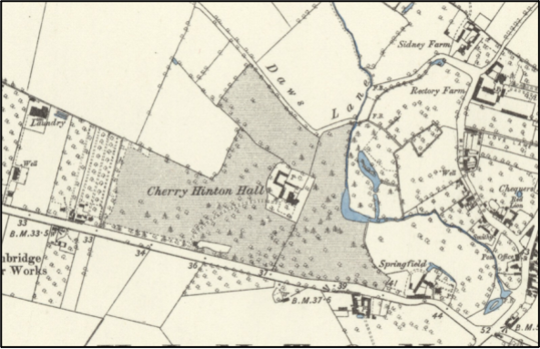
O.S map of 1886
The O.S map of 1886 shows the park with its water ways, planting, buildings and curved driveway. At this time, the Lodge can be seen with its plot of garden running to the east of the Lodge building.
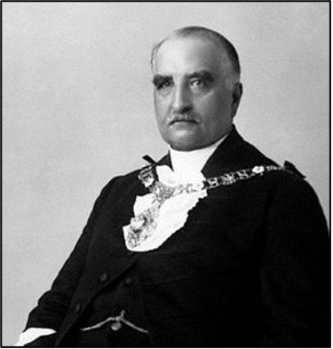
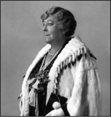
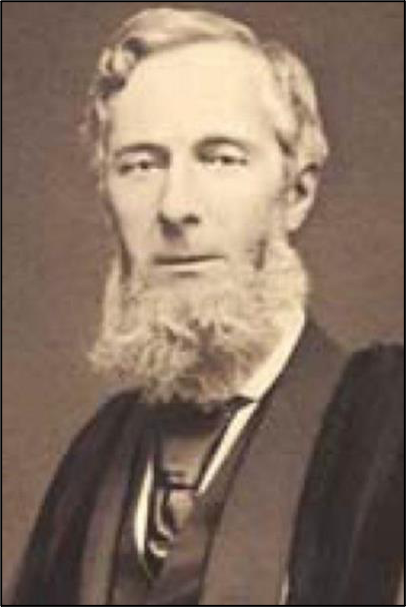
Robert Moffatt, a General manager of a bank in Cambridge, and his family lived at the Hall for a few years until Major Richard Thomas Lyons, a retired military surgeon, took over the tenancy for another couple of years until c.1900. Cherry Hinton Hall was then unoccupied for a short while until 1902 when Sir William Phene Neal and his wife moved in.
Sir William Phene Neal and his wife, Lady Eleanor Vise c.1902
Sir William Phene Neal who lived with his wife, Lady Eleanor Vise, at Cherry Hinton Hall, created the Cherry Hinton Hall Dairy Farm within the grounds. He went on to become the Lord Mayor of London in 1930 and local stories tell of remembering him being driven in a beautiful horse drawn carriage down the drive, from the park grounds and onwards to Cambridge train station, where he would travel to and from London. Last occupier of the Hall before its sale in the 1930’s was Lt. Col. Brocklehurst Phillips O.B.E.
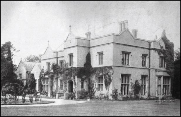
Cherry Hinton Hall in 1910, showing the drive return and front garden planting.
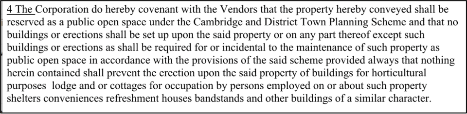
Ownership remained with The CUTWC and as such the Cambridge University Trinity Estates to which CUTWC was held, until 1937 when Cambridge City Council purchased the whole site, Hall and grounds and the site remains in their ownership today. This particular period was one where nationally the move to acquire and ornament public open spaces was prevalent. Cambridge City Council purchased the Hall and the grounds in May 1937, for £13000.00, and it remains in their ownership today. In November 1937, a conveyance document with covenant was drawn up which laid out the conditions of the purchase. The covenant stated that the site “shall be reserved as a public open space under the Cambridge and District Planning Scheme”.
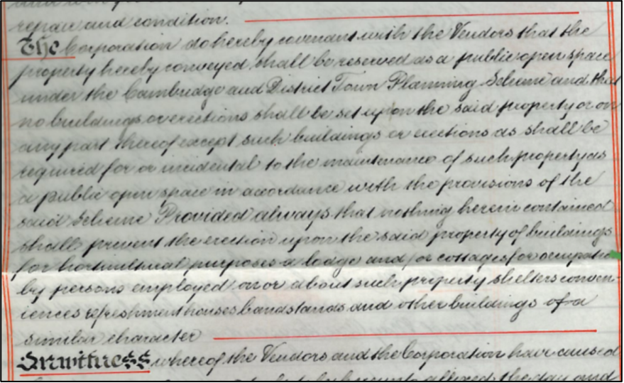
Original Deed of covenant, 1937 and Below: The transcription of this section
Some of the parkland was lost in the sale of the site to Cambridge City Council. A large portion, to the west of the site, was sold off to a Mr Ridgeon (now a well-known Cambridge building firm, Rigeons) and subsequently houses were built along this strip, along with the creation of a new road called Walpole Road.
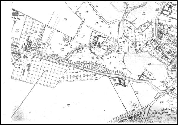
Cherry Hinton Hall c.1930 OS map, showing the planning position for Walpole Road, across the western side of the grounds. Note the Lodge garden is gone by this date and the driveway finishes at the Hall in a circular sweep.
For the first couple of years in the Councils ownership Cherry Hinton Hall becomes a Youth Hostel. With the outbreak of WWII, the Hall was used a fire depot and a training centre. It then became a home for young evacuees from London.
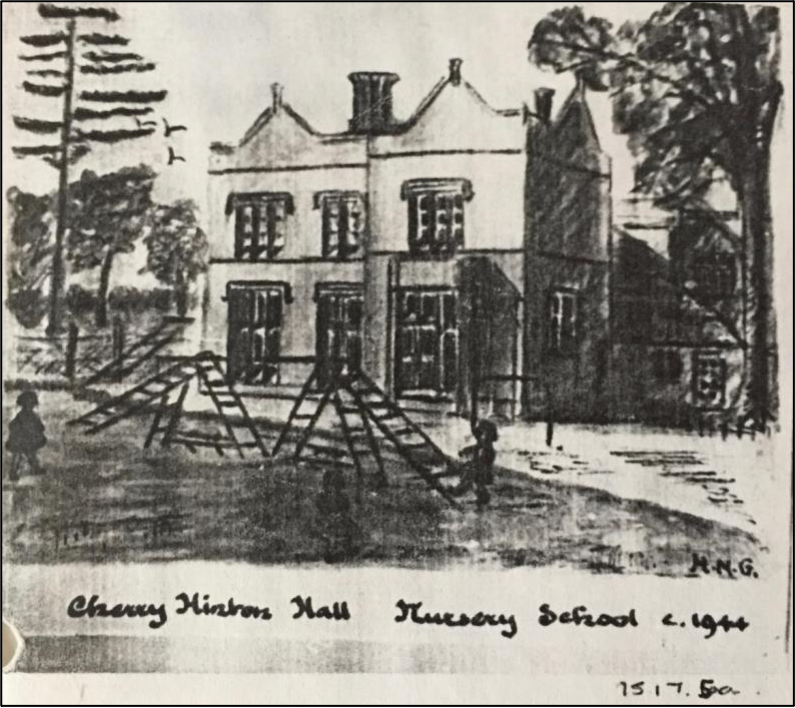
After Second World War Cherry Hinton Hall was used as an orphanage and by 1944 the Hall was host to a nursery school from 1944-1988.
Courtesy Cambridgeshire Collection
The Inventory of the Historical Monuments in the City of Cambridge, originally published by HMSO in 1959 contains the following entry for the Hall:
“Cherry Hinton Hall, nearly 3⁄4 m. S.W. of the parish church, of two storeys with cellars, has gault brick walls with stone dressings and slate-covered roofs. It was built for John Okes and the title to the property begins with the purchase of plots of land in 1834 (University Library, Map Room: sale advertisement, 1870). Scratched on the roof-lead is the date 1839, to which the house would approximate on stylistic grounds. Late in the same century a billiard room was added on the W. Since 1948 it has been converted into a day-nursery and clinic involving alterations and additions inside and out. The coach-house and stabling standing nearby to the N.W. have been drastically remodelled to provide living-quarters. The Lodge some 210 yds. to the S.W. is contemporary with the house. Cherry Hinton Hall is a large and rather bald building of the first half of the 19th century in the late Tudor style. The elevations generally have moulded strings at first-floor sill and eaves levels, tall parapet- walls carried up in gablets with moulded copings and apex-finials and stone-mullioned windows of one, two and three square-headed lights with labels; the ground-floor windows are transomed. The S. front is asymmetrical on plan and in height, the porch and the E. part being slightly higher than the rest westward. The doorway has continuously moulded jambs and four-centred head. The rectangular bay-window towards the W. end is an early addition. On the N. side is a four-light transomed window lighting the original staircase; to the kitchen is another of five lights on the W. side. The lights in several windows have been cut down for doorways and french-windows, others retain the original glazing of lozenge-shaped quarries. The chimneystacks have separate octagonal shafts with oversailing brick cappings. Inside, the staircase in the entrance-hall is a modern insertion involving the blocking of the four- centred archways in the N. and W. walls. The principal rooms have doorways with architraves and six-panel doors all with roll-mouldings; another period allusion is the heavy moulding of the plaster cornices. The E. part of the house retains two original fireplace surrounds of gray polished stone, with moulded jambs and four- centred arches, sunk spandrels and moulded shelves; they are flanked, one by pilaster-like responds with roll-moulded angles and moulded caps, the other by octagonal projections with trefoil-headed sunk panels in the faces. The main staircase has close moulded strings, grip handrails, square panelled newels and pierced strap work balustrading of gilded woodwork. The back staircase has cut strings, a turned newel and slender square balusters. The Lodge, of one storey, with gault brick walls with stone dressings and tile-covered roofs, of uniform character with the house, has been much enlarged. It has large gables, and a smaller gable to the porch, all with moulded stone copings rising from corbelled kneelers. The windows have stone mullions and the tall chimney-stacks octagonal shafts.”
The grounds of the Hall were opened up to the general public as a public park in 1960. The Lodge building was rented out to a park steward who was responsible for opening and closing the gates and other duties (the park ceased to have a steward by the 1990’s and the lodge building continues to be rented out privately by the City Council.) Before long, there was the addition of a car park to the south west corner of the site, just inside of the front gates, along with the addition of a public convenience. This public park development of the site included providing a healthily stocked duck pond and a bird sanctuary to the eastern area of the site within the waterways. The paddocks at the north-west of the site were turned into a games field and the site began to take shape in its new role for the pleasure of the public. This development also, in turn, enabled protection and preservation of the wide variety of mature parkland trees and features.
Within the Hall building the children’s nursey continued, and there was a health clinic and offices from the 1960’s until the 1980’s.
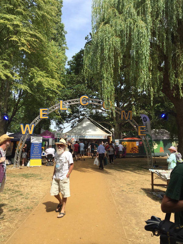
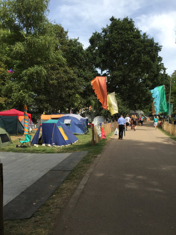
In 1965 the first Cambridge Folk Festival was held, set within the grounds of Cherry Hinton Hall. The Folk Festival has been held annually, at the site, at the start of August, ever since and celebrated its 50th anniversary in 2014. It has grown to become one of the premier music events in Europe and one of the longest running and most famous folk festivals in the world. As a result, Cherry Hinton Hall is known world-wide and loved by many thousands of people, who over the years have attended the site.
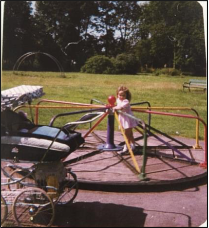
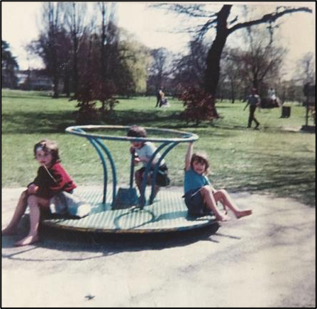
By the mid 1970’s a paddling area was provided within the Hinton Brook, just north of the duck pond and a play area, with playpark equipment, was in use to the west of the site, where the playpark area has remained since.
c. 1979, Playpark equipment in the Hall grounds, close to where the present-day playpark is now situated. The photographs show a see-saw, a roundabout and a climbing frame. You can also see a bench, showing that public park furniture was being provided by this time (©M.Bullivant)
During this time Cambridge City Council continued to use the Hall building for office space and the rear of building was used for the City Council’s storage and horticultural use, for which they built glasshouses and a developed a nursey/propagation centre to provide bedding plants for council planning schemes.
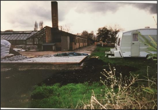
c.1995 - The council propagation centre and planting nursey (now demolished) at back in the Hall building, which would have once been the site of the Victorian kitchen garden. (©M.Bullivant)
By the 1980’s the site was in full use as a public park and had developed a reputation of a lovely place to visit. There were regular outdoor performances by brass bands and families used the site for picnics. Cherry Hinton Hall became a firm favourite with dog walkers and duck feeders across the city and beyond. By 1988 the Hall building was then rented by the council to Eastern Arts, an arts development company, who additionally provided some art for the grounds of the Hall for the public to enjoy. There was also a fenced-off special bird sanctuary, to the east of the site, on the island beyond the lake and more wildfowl were introduced to the site.
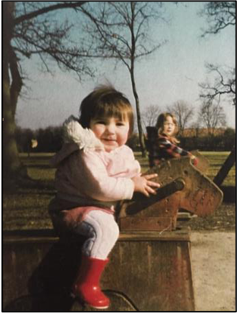
c. 1984, Playpark equipment in the Hall grounds, close to where the present-day playpark is now situated. The photographs show a new roundabout and ‘rocking’ horses. (©M.Bullivant)
In 1987, a refreshment kiosk was opened on the west side of the building, this was only in service for a short time.
Aerial Photograph of Cherry Hinton Hall 1987 showing the site. (Courtesy of Cambridge University Committee for Aerial Photography).
During the 1990’s the playpark was further refurbished, with distinct toddler play areas and older children areas. A major new paddling pool area was constructed, which consists of two pools, one for general use and one for toddlers.
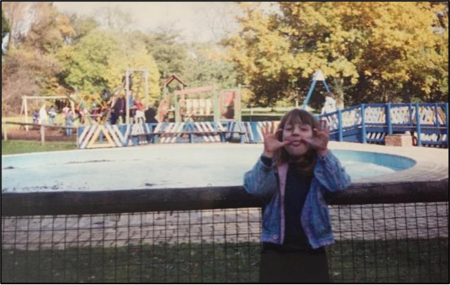
The newly built paddling pool, c.1995 with playpark in the background. (© M.Bullivant)
This wall was one of two original entrance walls, either side of the front door to the Hall building. This western wall, shown, was removed in the late 1990’s to make adaptions, in the form of a sloped pathway, so that the hall was wheelchair accessible, as previously, at the front of the entrance walls, were several steps. (© M.Bullivant)
In the 2000’s, tennis courts were added to the site, just immediate north to the playpark area and exercise equipment was also added. The bird sanctuary had closed by this time and some tree art was made from trees that had been retired. Further play area improvements were made with the addition of an accessible, disabled play equipment.
When I first started my research into the history of the Hall, back in 1998, I was amazed to learn that the buildings were not even grade listed. So I set about finding out how one goes about such a thing and I was successful in getting the Hall and buildings listed. If I can do it, so can you - always have a check if you think a building should be listed and now a days you can do the whole process online. I know it can be a mixed bag in some respects because of restrictions that then get placed on a building but I really did think it worth getting the Hall listed, to protect it for us all as it is a public park and we locals love it.
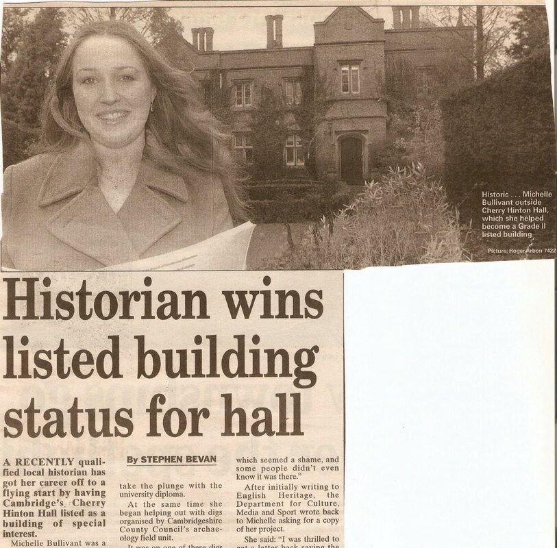
Courtesy Cambridge Evening News
Cherry Hinton Hall is a Grade II listed building and was added to the Statutory List on 19 September 2002, along with the Lodge, gate piers and the gates at the drive entrance. The list description is provided below:
“667/0/10138 Cherry Hinton Hall 19-SEP-02 Grade II
Small country house, now training centre. 1839. For John Okes. Gault brick with stone dressings and parapeted slate roofs. Ornamental brick stacks, some with multiple flues. Tudor style with coped gables with finials. 2 storeys, attic and cellar. Entrance front is a 6-window range in all at first floor of 2-light casements with hood-moulds (single-light 2nd from left). To centre right is a projecting gable with a panelled door with Tudor-arched surround and casements to side walls and over. On the front to both sides of this projection are 2-light stone mullion and transom windows, one to right and two to left, some with leaded lights. On far left a gabled projection with large square bay to ground floor. Two gabled ranges further to left, one single-storey, the other 2- storey. Front to right has 2- and 3-light casements over taller similar mullion and transom windows with a canted bay to right. Rear has various wings and C20 extensions. A large leaded mullion and transom window lights the main staircase. INTERIOR. Entrance hall has arched screen and carved stone fireplace. Staircase hall has open well staircase with pierced fretwork balustrade. Other reception rooms have similar stone and marble fireplaces. Simpler fireplaces on first floor. Cornices and panelled reveals in some rooms. Service stairs with stick balustrade. Service wings have mainly C20 character. Cherry Hinton Hall is a well-detailed house of the period which retains many exterior and interior features. It forms a group with The Lodge and gate piers and gates at the drive entrance.”
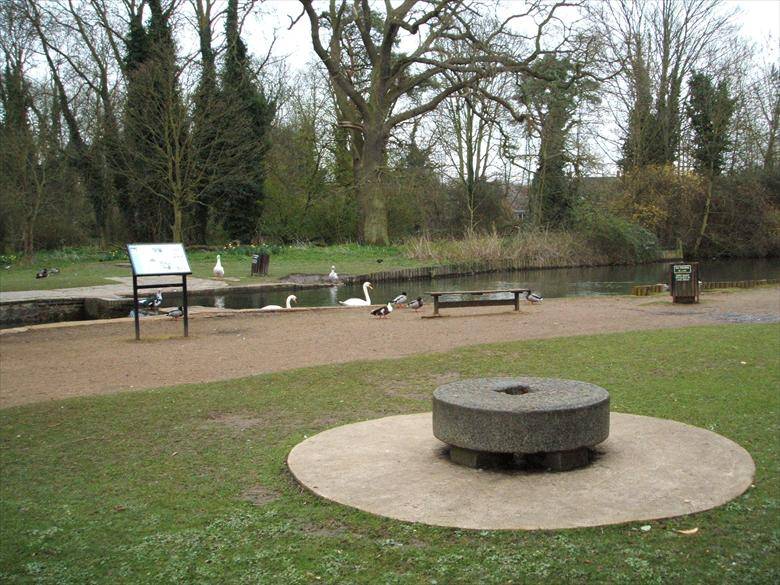
In 2004 I ran a community archaeological investigation. A 'dig' around a small area of the site was carried out, within the lake are in order to establish the whereabouts of a lost medieval watermill site. The work was designed to include participation from the children of one of the local secondary schools and the end result was 2 different interpretation boards for the park along with public information leaflets, a better understanding of some of the archaeological history of the site and the discovery of one of the original medieval mill stones, who now makes an unusual seating feature by the Hinton Brook and information board. The site, as a whole, remains rich in archaeological remains and potential for future excavation and investigation.
I will do a separate blog post on here about this - 'The Lost Watermills of Cherry Hinton"
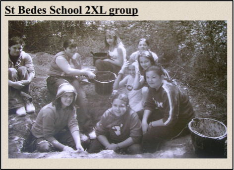
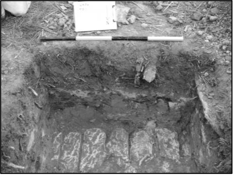
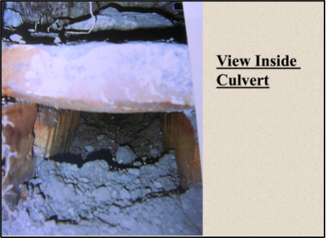
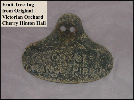
Photographs from the 2004 excavations at the Cherry Hinton Hall, Lost Watermills Excavation. Top Left: Children getting hands-on experience. Top Right: Capping stones of an old culvert discovered. Middle Left: View inside the culvert, which proved to be from the medieval watermill workings. Middle Right: A Victorian metal fruit tree tag, from John Okes’ orchards.
Bottom left, unveiling of the new information board by the lakes, about the findings and the lost watermills of Cherry Hinton. Bottom right, the new board by the lakes and the original medieval mill stone that I found on site during the project, now placed as a seat for all to enjoy. (© M.Bullivant)
After the departure of Eastern Arts, the Hall building has been leased to The Cambridge International School, since 2008, who remain the tenant of the building today. The school have just completed a major redesign and refurbishment of the main Hall buildings, at their own expense, including the building of a new all-purpose Hall, named The Okes Hall, at the rear of the main Hall. The Council continues to use an enclosed area to the rear of the main Hall building for storage and other council use, including a service area for when the annual Cambridge Folk Festival takes place.
With the design of the Master Plan for Cherry Hinton Hall in 2009 by Cambridge City Council and its subsequent implementation over the last 9 years, along with the formation of The Friends of Cherry Hinton Hall in 2009, it is clear that people still care and are passionate about this special place and that whilst utilising the site, it should be preserved and protected.
In the 21st century, the park remains an important amenity for visitors, students, and local residents, being an important green space between Cambridge town and Cherry Hinton, giving the village of Cherry Hinton some much needed distinction and preventing it being swallowed up to become an indistinct suburb of Cambridge City, whilst at the same time being within easy reach of the City and Cambridge Train station. The park is also in close proximity to Addenbrooke’s Hospital, a major employer in Cambridge providing, not just green relief for the staff, but also the visitors to the hospital. In addition, the Cambridge Silicon Valley and technology park is only a few minutes’ walk away from the park, the site proving a popular lunchtime space for its workers. The proximity of several schools to the site means that the grounds are put to good use for educational purposes and the site remains an important tool, for positive development of future generations.
So, there you go, that hopefully gives you a good general feel for the main points in the growth and development of the site and a bit more about its history. I have no-end to add to this which I have already written down, from much more detail about John Okes, who built the Hall and his family, to more in-depth details of happenings at the Hall and grounds over the years, including many written memories from many people, old photographs and voice recordings. I will bring you all these in due course :)
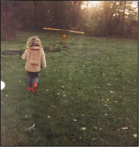
If you'd like to support the work that I do, why not buy me a virtual coffee, I'd be really grateful and it will help keep me going! Just click on the green button below :) 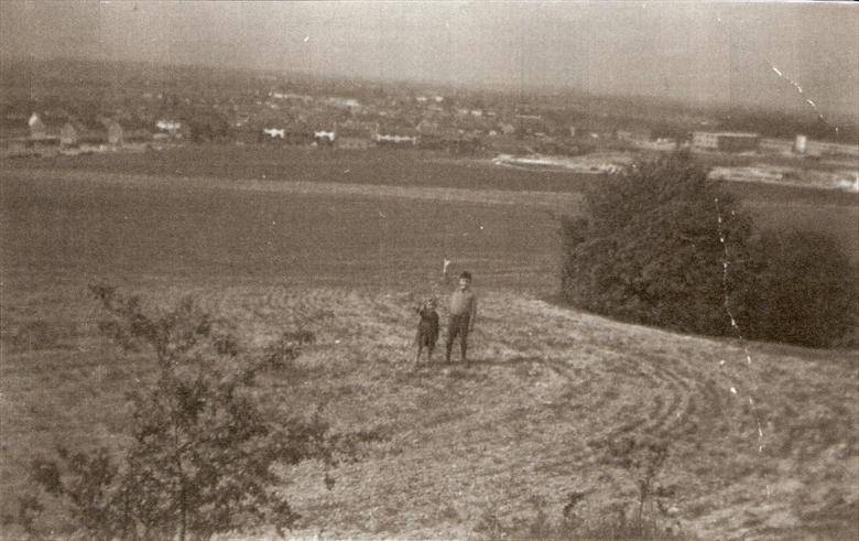 This is a view from the top of Lime Kiln Hill looking across the City of Cambridge. It's one of the great places to see the city and fantastic sunsets. It's also little known, many people not realising that such a 'hill' occurs by the city! In the picture is my mother Elizabeth Toller-Brown and her brother, my uncle Dave Toller - they had just moved from the other side of town (Oxford Road) to just towards the bottom of this hill on Netherhall Way.
 The Cherry Hinton chalk pits are on Lime Kiln Hill at the north western most spur of the Gog Magog Hills. The top of this hill comands impressive views across the town of Cambridge and beyond and as such has been an important site of settlement and defence since prehistoric times, an Iron Age fort known as The War Ditches was discovered on the site in the late 19th century. The quarrying and industrial use of the site has gone on from at least Roman times due to the high quality chalk and clunch (superior chalk). Cherry Hinton clunch was used, during medieval times, in buildings such as Ely Cathedral and the Cambridge Colleges. Quarrying and lime burning at the site continued at the site well into the 20th century.
Courtesy of Cambridge University Library Spring Head is the natural spring pool that breaks forth at the base of the Gog Magog Hills. It was one of the original reasons for the siting of the village of Cherry Hinton and is still, today, the village pond. Spring Head is also known locally as Giant's Grave and there are still superstitions about the site, which are closely connected to the tales of giants once living in the area and on the Gog Magog Hills. Spring Head feeds the Hinton Brook which flows on through Cherry Hinton and Cambridge to join with the river Cam.
The Tutton (or Tottenhoe) Way is an ancient route-way that skirts the eastern edge of Cherry Hinton old parish, now Ward, and now also forms the eastern Cambridge City Boundary.
VIDEO 1 of 3 - Tutton Way
The Tutton Way, from the top of the Gog Magogs, on Worts' Causeway, opposite the Shelford Gap, looking down towards Cherry Hinton village and across Cambridge.
I can, so far, trace this boundary from the northern end of Bridewell Road in Cherry Hinton where it joins Fishers Lane, following through the back gardens and the line of this routeway south, to meet up with the small passage way at the other end of Bridewell Road, that leads through on to the Back Field, where it continues on in the form of a paved footway to join Fulbourn Road. It then crosses straight over Fulbourn Road and enters the northern boundary of the Gog Magog Hills, where it travels up through a field edge as a trackway, going first alongside the eastern edge of the Peterhouse Technology Park and then continues up over the hill, in a straight line, through the fields as a wide trackway (currently closed to the public). The Tottenhow Way then meets the Worts' Causeway Road at one of the highest points on the Gog Magog Hills, where, straight across the road, it continues, for a short way, as a wide trackway named the Shelford Gap before apparently ending at the thick hedge line beyond which the Gog Magog Golf Course lays. It also meets the apparent end of the Roman Road, collectively known as Worstead Street or Wool Street. The Roman Road leads off of the end of the Shelford Gap (Tutton Way) in a south easterly direction, in a long straight line for many miles.
VIDEO 2 of 3 - Tutton Way
At the end of the Shelford Gap, looking north, toward the cars parked on Worts' Causeway. This is really an extension of the Tutton Way and this is the point where the Roman Road leads off to the right.
There is a little bit of a dirt track entrance/parking on the roadside by the start of the Shelford Gap on Worts' Causeway and barriers to prevent vehicles driving down the track but it is a popular place to start the walk down the Roman Road. However, it’s not very advisable to go there alone and there are, shall we say, interesting individual and collective, unusual activities that go on at that spot, particularly as there is a small wooded area alongside the trackway. It is not really very safe to walk up to this point as there is no real safe footpath from Cherry Hinton, so going by bike or car is currently the safest way.
From Cherry Hinton the route is taken, starting from the Robinhood at the junction of Cherry Hinton High Street and Cherry Hinton Road. Go straight over onto Queen Edith’s Way. Take the first turn on the left to drive over Lime Kiln Hill, at the immediate base of Lime Kiln Hill, where there is a crossroads. Take the next left to drive up Worts' Causeway, passing the Beech Woods on your right, continue up the hill until you reach the crest, where you will see the parking area for the Shelford Gap on your right hand side. You will be able to cross the road on foot to look north over the Tutton Way and see the spectacular views across Cambridge, Cherry Hinton and beyond. If it is a very clear day you will also be able to spot Ely Cathedral in the distance (about 20 odd miles away.)
Once you’ve finished your visit you can either go back the way you came or you can continue along the road eastwards, turning right, as you come out of the Shelford Gap on to Worts' Causway, where it then becomes Shelford Road. It will lead you over the hills, with lovely views, where you’ll also be able to see the sails of the Fulbourn windmill on your left as you make the descent down towards the village of Fulbourn. At the bottom of the road you’ll meet with Cambridge Road and mini roundabout, where you can turn left and follow the road straight back to the Robin Hood pub in Cherry Hinton.
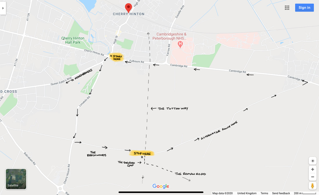
Directions to the Shelford Gap with the route of the Tutton Way, which is now a private road in part.
I think, on the whole, hardly anyone today knows about the existence of the Tutton Way, other than the people who remember me talking about it when giving local history talks to groups, where I would mention it now and then. I had found out about it from reading old documents, maps and surveys from Cherry Hinton when doing my research on the village over the years. Being stuck in isolation during the lockdown is giving me chance to write up a few things that I’ve been meaning to write about for some time, including the ever-allusive Cherry Hinton Local History book that I’ve been promising to write for years. So, I thought I’d start with writing about a few of the places you can walk to or get to, for nice walks and offload some of the information and theories about the archaeology and local history of the area, out of my head and onto paper/screen, with an idea to start forming the book that I must get done.
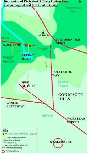
Prehistoric Cherry Hinton Map ©Michelle Bullivant 2010
The map above, that I made some time ago, gives you an idea of some of the routeways and sites in and around Cherry Hinton during prehistoric times. I have placed the current main church building of St Andrew's on the map just to help you get your bearings. You can see the Tutton Way (Tottenhoe Way) that we are discussing, you can also see the Roman Road and the projection of its, potentially earlier route. You can also see the hillforts of Wandlebury and the War Ditches. I also mapped out the (at the time) known burial (barrow) sites, showing their relationship to the routeways. It just gives you a basic illustration of the area that we are looking at and makes the point that you can often tell ancient (pre Roman) boundaries and route-ways as they are often have barrows and other markers along their course.
At the end of the Shelford Gap, near to where it meets the Roman Road, were once two locally known barrows, nicknamed the Two Penny Loaves: "Smith's carrier's cart turned right from Fulbourn, heading south into rolling countryside. All the way it creaked ever upwards, till at the top of a ridge they reached an ancient track which was apparently an old Roman road linking Cambridge with Colchester, the way marked by two barrows, called by local people the "Two penny loaves" (Pickwick's Cambridge Scrapboook 1838, Mike Petty) "At this point, where the road returns to its original direction, there are the remains of two tumuli, called the Two- penny Loaves, one of which was opened in 1778, and seven skeletons were found at its bottom ; six of them were laid close together and parallel, with their heads pointing due north, the other lay with its head directed due west, and its feet next the side of the nearest of the six (Nichols's Lit. Artec, viii. 631)" (Ancient Cambridgeshire, by Charles Babington, Cambridge Antiquarian Society) 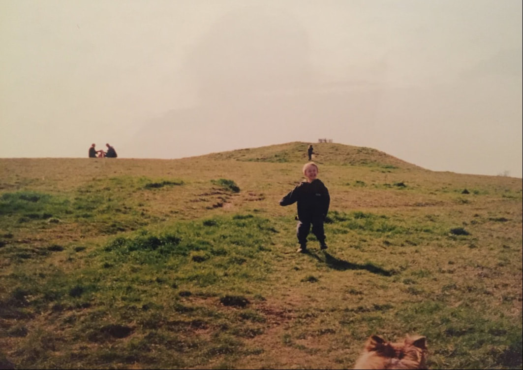
The picture above (with my son in the foreground and daughter climbing in the background, many years ago) gives you an idea of what Bronze Age burials mounds, or barrows as they are also called, look like. The one above is situated on Thurfield Heath in Royston, not that far away. You may often drive past them at the side of roadways and not realise what they are, a good example is of the one on the A11 as you drive towards Norwich from the 5 went ways roundabout at Barton Mills. The Two Penny Loaves would have looked something like this, standing side by side. However their fate, as with many of these barrows, was that they were excavated and destroyed, with the majority of barrows being ploughed away over the years to only occasionally be seen on aerial photographs as a crop mark on the ground. After lockdown, I will see if the Gog Magog Golf Club will let me go and have a look for the site of the Two Penny Loaves and report back to you if any sign of them remains.
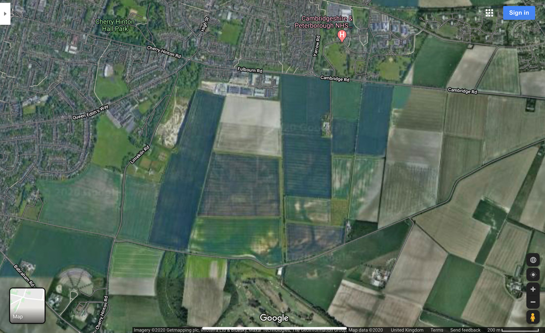
An aerial view of the Tutton Way and Shelford Gap. See if you can follow it's line from Fulbourn Road, where it runs alongside the end of the Peterhouse Technology Park, south to join the Shelford Gap.
One of the earliest descriptions that we have of the layout of some of the land in Cherry Hinton comes from a written survey of the Manor of Netherhall in the Parish of Hynton from 1592 (Separate articles on the Manors of Cherry Hinton and place names in the area soon). Unfortunately this survey, carried out by Christopher Saxton (you can read about him on Wikipeadia), is a written survey only with no accompanying map that we know of. This means we have to go by the written descriptions within the old open fields of the parish to work out where he is talking about.
The main open field that the Tutton Way traversed was called Quarry Field, it was a large area covering across from Lime Kiln Hill, on the Gog Magogs, eastwards to the parish boundary (the Tutton Way). Saxton gives the following description and land measurements:
"Quarry Field... The Furlong abutting the Totton Way - One piece lying in the lands of ..Junior South - 1 acre, 0 roodes, 5 dawks and 3 pches One piece laying between the lands of Uphall on the east and Gilbert Wise on the west - 0 acres, 2 roodes, 8 dawks and 2 pches" (London Metropolitan Archives, H01/ST/E/106/002) So here we see the first known written mention of the Tutton Way - spelt by Saxton, as 'Totton'
The next reference to the Tutton Way can be found in the Survey of St. Thomas' Hospital Land in Cherry Hinton, 1733 by John Tracey. (Survey of Hospital Propery at Cherry Hinton, by John Tracey, 1733. London Metropolitan Archives, H01/ST/E/107/003) which again was a written survey based within the old open fields of the parish but this time, contained three simple maps. One of which shows the route way, within Quarry Field, called Tutton Way. I'll order a decent copy of the map and place here, after lockdown, so you can have a look.
Here you can read a bit more of a very good, general overview about the Roman Road, written by my friend and colleague Tim Malim. You will see that this link takes you to the Friends of The Roman Road & Fleam Dyke website, where you can have a little bit more of a look at their take on the Cambridge Dykes. I will do a separate article or two about these and The Roman Road myself at some point soon because if I start on these now I’ll get completely side tracked and loose my focus on the Tutton Way - research is never really done!
https://frrfd.org.uk/archaeology-and-history/roman-road/
If you want to know a bit more about Wandlebury, for now, you can follow the link below, to take you to the Cambridge Past, Present and Future website, who look after the Wandlebury site.
https://www.cambridgeppf.org/wandlebury-history And more on the War Ditches can be read here, linked from the Wildlife Trust website who now manage and care for this particular site. https://www.wildlifebcn.org/sites/default/files/2018-05/East%20Pit%20Archaeology%20Report_0.pdf Again, I will write something further on both Wandlebury and the War Ditches at some point soon and post here on my website for you but I just need to focus on one thing at a time or I shall be drawn into writing great reams of theories, arguments and never actually getting anything up and published for you.
The earliest maps and surveys, that I’ve mentioned above, call the routeway the Tutton Way or Totten Way, where as I have seen it also named the Tottenhoe Way on a later map. There are a couple of possible meanings to this name – If we start with the earlier ‘Tutton’ it could be a derivative from the word ‘tot’ meaning fool or idiot, perhaps indicating a more perilous routeway – the fools way. Another thought is that ‘toten’ is the German word for ‘dead’, suitable for an ancient routeway lined with the burials of the ancestors perhaps? However, the later used name of 'Tottenhoe' makes a little more sense in many ways, as Totternhoe is a village in central Bedfordshire where the Totternhoe stone is sourced, now bear with me, as this does relate to our site in some regard – Totternhoe stone is not hard stone, it is a seam of very strong, durable chalk which was quarried in that area for use in great buildings, such as Westminster Abbey. Here in Cherry Hinton, from at least the Roman period, the strong building chalk, known as clunch, has been quarried and in turn used in such buildings as Peterhouse College and Ely Cathedral. You can see the evidence of this at East Pit off of Lime Kiln Hill, in the large open quarries there, which is only a stones through from our Tutton Way. Perhaps the name related to this strong chalk and its quarrying industry. Does the chalk seam run from Bedford through Cambridge? Burwell village, to the north east of Cherry Hinton, also used to have chalk quarries where the Burwell Rock would be quarried for building use in similar ways.
A quick google for you, rather than me spending ages going through the piles of old maps that I have here, reveals some further information, from Cambridgeshire Geological Society, which gives this latter theory more credence as being the most likely for the naming of our routeway. http://www.cambsgeology.org/565-2-3-2 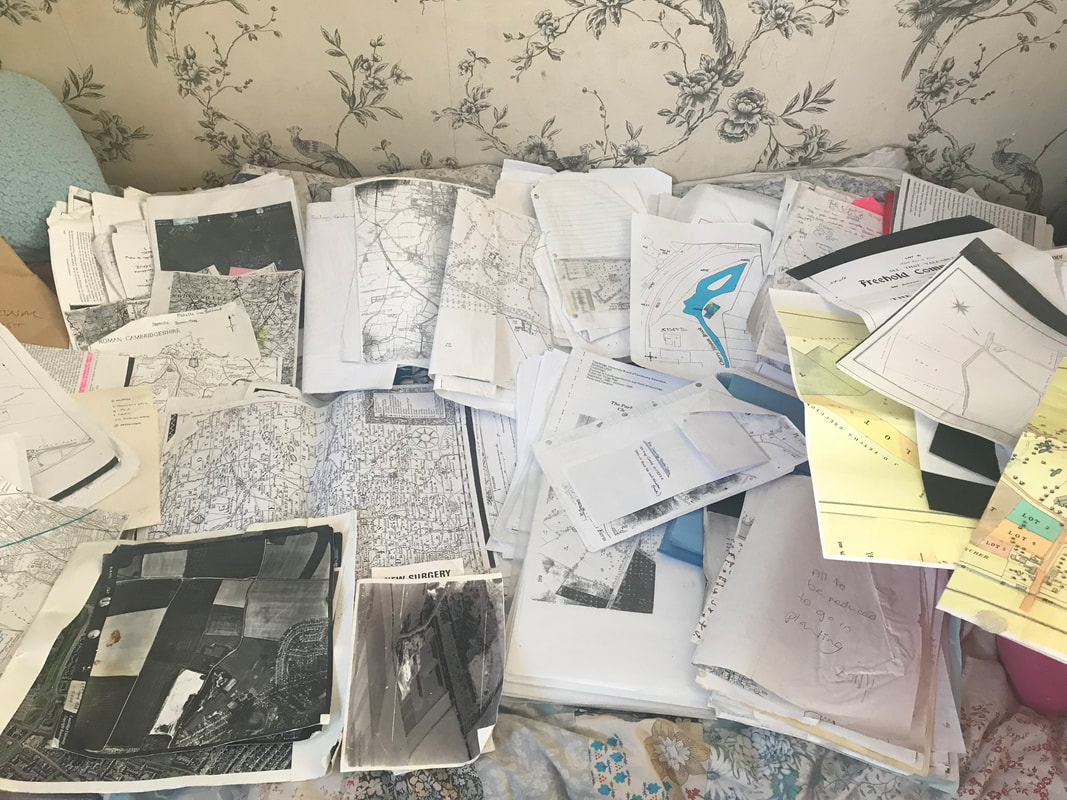
Just a small pile of the old maps, aerial photographs, documents and such like, that I have to organise, all relating to Cherry Hinton and my research.... as I find anything relating to the Tutton Way, I will add it on to this post.
If you go onto the Back Field in Cherry Hinton, at the eastern end where a passageway leads through on to Bridewell Road, you can stand on the Tutton Way as it cuts over the back field in the form of a wide paved pathway, which leads out onto Fulbourn Road. Once out onto Fulbourn Road, you will be able to see that this spot also marks the official Cambridge City Boundary, with a sign, again highlighting the importance of this ancient boundary. The back field is a Cambridge City Council owned green space which local residence use to walk their dogs and the staff, at ARM across the road, come out to have games of cricket and sit and enjoy their lunch. In the autumn there are great amounts of blackberries to be picked and in the spring the boundaries are covered in yellow daffodils. The Back Field runs from the passageway that runs into Leete Road, off of Fulbourn Road and it ends just before the hedges as you approach the roundabout at Yarrow Road, Fulbourn Road junction.
VIDEO 3 of 3 - Tutton Way
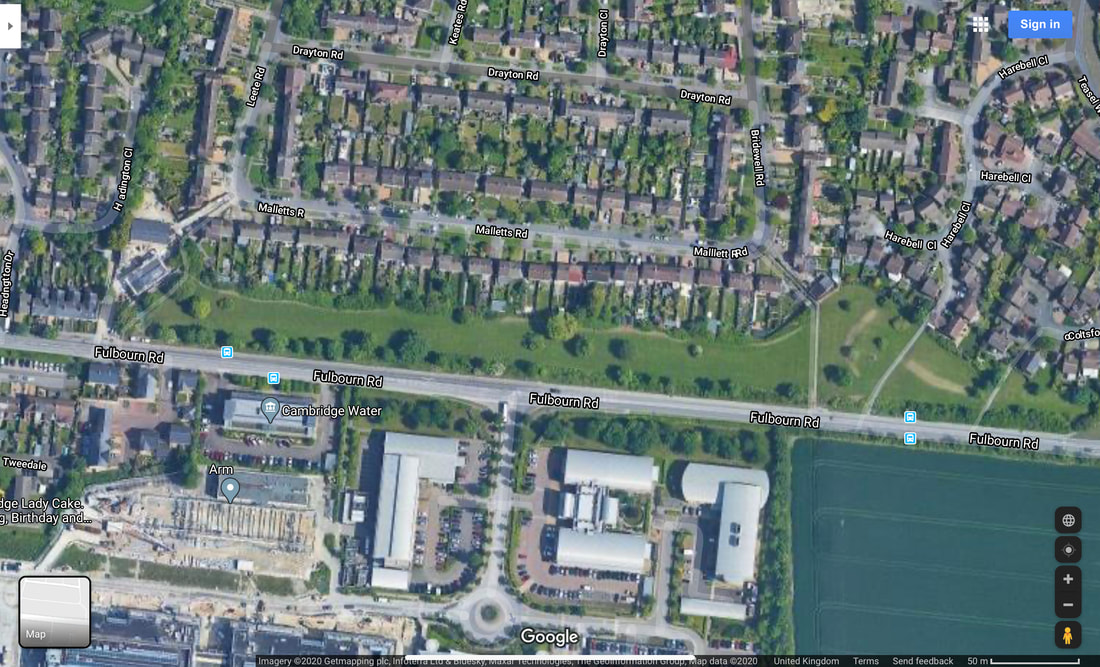
Aerial View of the Back Field on Fulbourn Road, with the Tutton Way crossing over it, on the right hand side, in the form of a pathway leading across the road and alongside the Peterhouse Technology Park, continuing up onto the Gogs
The Tutton Way can be seen in the form of an earthwork running along inside the back gardens of the houses on the eastern side of Bridewell Road. My mum used to live down the end section of this road and there was a large, clear slope running up and through her back garden which was not a natural slope but man made.
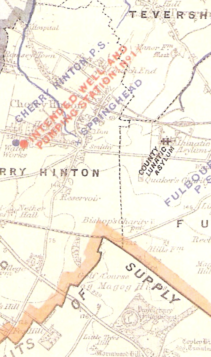
https://cherry-hinton.ccan.co.uk/content/catalogue_item/cambridge-water-works-supply-map-showing-spring-head-cherry-hinton, Cambridge Water Works c.1900
The map above (which you can see in full on the Cherry Hinton Community Archives website), shows the parish boundary marked by a dotted black line. As it stands and from what we (you and I) now know, the Tutton Way ends were it joins the old Roman Road at the end of the Shelford Gap, however, you can also see that if you were to draw a straight line from this point over the Roman Road, that the Tutton Way would lead straight into Wandlebury hill fort. I would strongly suggest that it did just that, once upon a time.
If you then follow the Tutton Way north, across the field and back towards Cherry Hinton village you come to a point where the parish boundary abruptly turns to the right, up and then to the left again, creating a off set square shape. The point at which the boundary turns is where the Tutton Way ends, as far I can tell at this time. This point is at the bottom of what is now Bridewell Road, where it meets Fisher's Lane in Cherry Hinton. The odd square actually marks out where there was once a some common land, it was called Drayton Common. It can easily be imagined that cattle were put out to pasture on the common land at this point and then driven up onto the higher ground, along the Tutton Way, perhaps in even earlier times, all the way into Wandlebury encampment itself. However, more research and on the ground field work is needed to really test out and explore if this really was the extent of the Tutton Way. It good fun to get out the maps and look on aerial views of the site and see if we can look for clues and trace the line of this old route way any further - perhaps the route continued across Drayton Common to meet at the crossroads by the church, with what is now Church Lane, the High Street and Fulbourn Old Drift? Or did the route turn at some point and join Daws Lane which runs bend Cherry Hinton Hall and was one of the old route-ways into Cambridge? etc. etc..
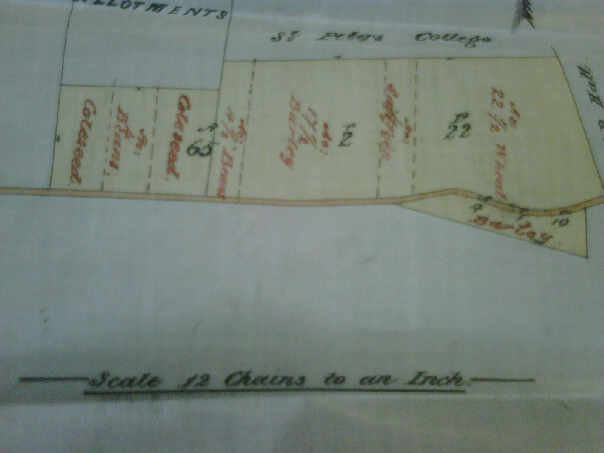
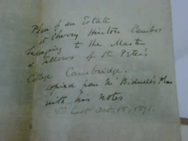
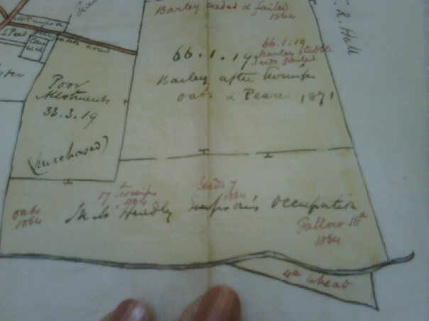
Below are a selection of photographs that I took of some of the records held by Peterhouse College, who owned a lot of land in Cherry Hinton. I am afraid that the pictures rea not very good quality as they were taken some years ago on an old phone or camera, so I must get back to Peterhouse to get clearer images. The pictures below cover the area around the Shelford Gap and are from the 1870's, recording what crops were grown and if they were successful etc. The important thing of note is that within the written columns Quarry Field is mentioned along with "Furlong abutting the Totten Way" - so the name was still in use for this route way around this date.
As always, research is never finished and theories evolve as more data becomes available but they must all start somewhere - an idea, a clue and most importantly curiosity. I will add to this and any other of my posts as and when I discover some new piece of information to add, in the meantime I hope this has been of some interest to you all :)
If you'd like to support the work that I do, why not buy me a coffee, I'd be really grateful and it will help keep me going :)
|