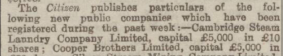
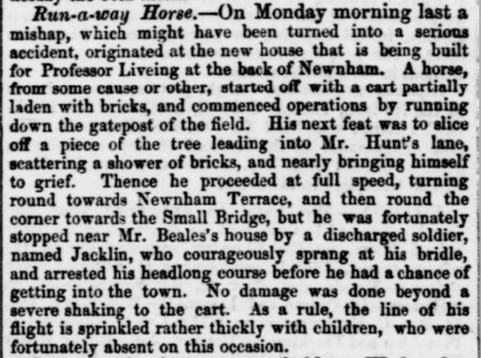
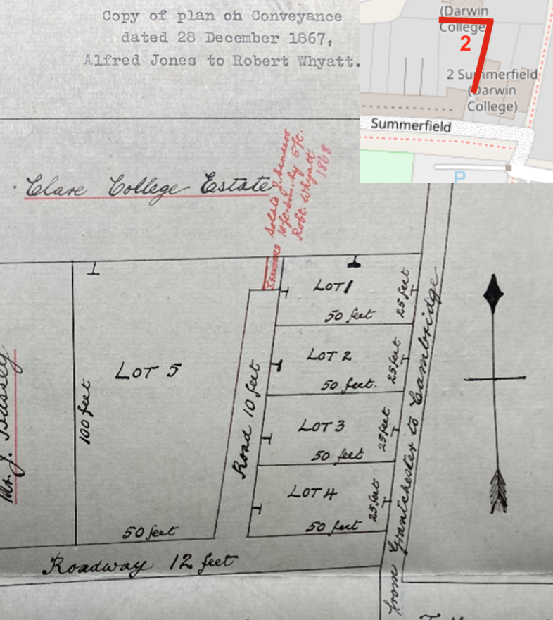
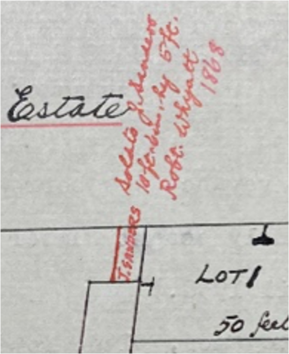
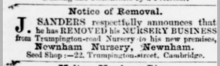
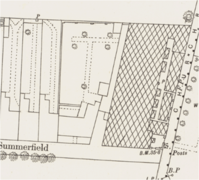
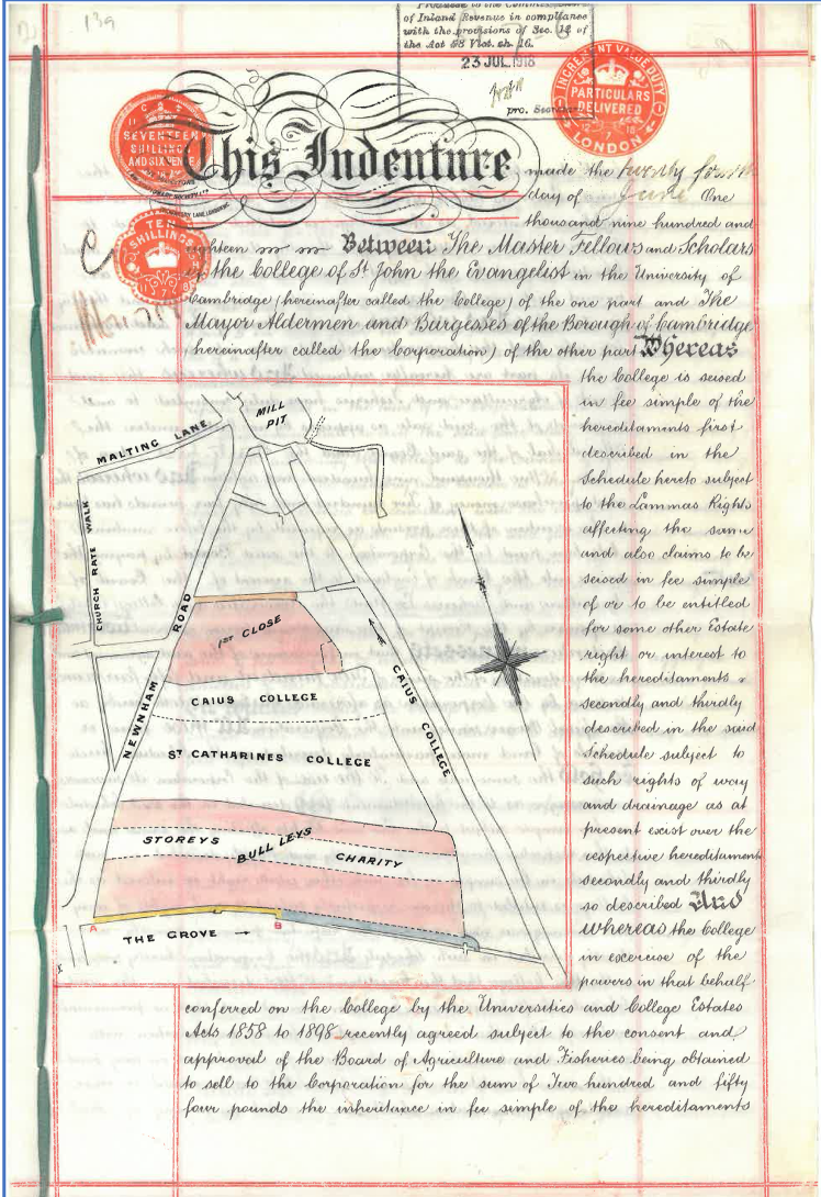
Michelle Bullivant Local Historian & Landscape Archaeologist
  • Home
    • About
    • Historical & Archaeological Services
    • Reviews
  • Cambridgeshire History
  • Cherry Hinton History
  • UK History
    • UK History Contents
  • Downloads
  • Gift Shop
    • Wanted
    • Site Policies
  • News & Updates
  • Contact

Cambridgeshire History

Newnham Walls (Newnham, Cambridge) Church Rate Walk/Newnham Walk/Summerfield.

1/8/2023

0 Comments


Newnham Walls (Newnham, Cambridge)
Church Rate Walk/Newnham Walk/Summerfield
The Cambridge White, capped, brick walls.

Wall at Newnham Path
Figure 1 Wall at Newnham Path
​There are several walls of the type above in this area. I have initially identified what seems to be 3 separate sections[1]. They are provisionally dated to the latter part of the 19th century and are constructed from Cambridge White bricks, (made near Ely or perhaps the Newmarket Road brickworks in Cambridge?) They are capped with an angled brick to allow rainwater runoff and finished with an oval capping brick. Given the similarity between these walls in this area, it would be nice to discover what they were bounding and from what date. How, if at all are they connected to one another?
​
[1] It must be noted that this document is put together after only 2 or 3 brief site visits and that I have not explored any further than what you see here – I have not yet examined the walls in detail or been on the other side of them, so this document is intended to bring this initial exploration to light and provide ideas and inspiration for someone else to explore further should they so wish – or at least to make your next walk in this area a little more curious.
Newnham Location Map
Figure 2 Location Map 1 © OpenStreetMap contributors
The walls are within the Old Newnham area, just west of Cambridge City Centre.
The location of the 3 sections of the similar wall is shown on the above map with red stars. 
1. Church Rate Walk wall. 
2. Summerfield wall. 
3. Newnham Walk wall.
Newnham walls Location Map
Figure 3 Location Map 2 © OpenStreetMap contributors
The position of the 3 sections of the similar wall is shown on the above map with red lines.

1. Church Rate Walk wall, turning onto Newnham Path, faced by the terraced houses there. 
 
2. Summerfield wall marking the boundary between No.s 1 and 3 Summerfield and turning to form the back garden boundary of No. 3 Summerfield. 
 
3. Newnham Walk wall bounds the northern section of Newnham Walk Surgery and continues to curve around and join The Pightle house. It then continues on the other side of this house until it meets The Principal’s Lodge.

1. Church Rate Walk Section

Church Rate Walk looking south
Figure 4 Church Rate Walk looking south
​View south, down Church Rate Walk, with the capped wall on the right of the footpath, just beyond the white houses (the wall on the left of the footpath is a different design).
Wall at Church Rate Walk & Newnham Path
Figure 5 Wall at Church Rate Walk & Newnham Path
​On the left is the continuation south of Church Rate Walk, showing the capped wall running alongside. The capped turn, centre top of the picture, shows a well-executed and defined end to the section of wall here, where it turns west and continues at a lower height. It shows the termination in the northeast corner of whatever this wall was bounding. 
 
Being on a public footpath the wall is higher along the path on its eastern line, than on its north section where the path runs in front of the small terrace of houses in Newnham Path (which is a dead end) and where the path here is also lower down.
Wall at Newnham Path
Figure 6 Wall at Newnham Path
Here you can see the view from Church Rate Walk looking down Newnham Path, towards the west, with the short terrace of houses on the right of the picture and the capped wall on the left.
​
The wall, in the centre of the picture, adjoining the capped wall at a right angle, is a later addition of Cambridge White’s which provide screening for a bin area (once coal?).
 
It is worth noting the use of the wall for the growing of plants as this can provide a good deal of history to the use of the wall on this side. The patterns and variety of nails and holes can be plotted and can sometimes indicate different types of flowers or produce grown against the wall. 
 
The far boundary wall we will look momentarily, but first notice what looks like a couple of pale white bricks on our capped wall, roughly bottom centre left, in the photograph above. If we look at the next photograph, we will see that it is in fact a line of wood embedded into the wall.
Wood in the wall at Newnham Path
Figure 7 Wood in the wall at Newnham Path
​In the photograph above you can see the wood more clearly. The question is why is it there? 
 
Was it a piece of wood that was placed in the wall after removing the face of some of the bricks to create an alcove for it to fit in? and if so, was this for wall planting/attaching or some other purpose? If you look closely at the photograph, you will see a thin, vertical strip of wire and an old nail within the wood supporting this.
 
Was the wood placed there at the construction of this wall – does it completely replace any bricks – with permission, we could look at the other side of this wall to see if it shows there too. Was it a sill of some kind? I cannot immediately see alterations present in the wall here to indicate that there was previously an opening above it. More time is needed to thoroughly survey the wall.
Wall in Newnham Path southwest corner
Figure 8 Wall in Newnham Path southwest corner
​Moving on to the back end of Newham Path, this northern section of the wall meets another brick wall, which is taller and made of Cambridge Whites but seems to cut across our wall, perhaps indicating a slightly later date for the taller wall. 
 
Did our wall once continue on beyond this wall? Did it always end here, or did it once turn south here and meet up with the capped wall at Summerfield?
 
We will now come out of Newnham Path and turn back onto Church Rate Walk to follow our wall south.
Church Rate Wall looking north
Figure 9 Church Rate Wall looking north
​Here we have turned out of Newnham Path and gone down Church Rate Walk, as far as our wall extended to, we have now turned around to look back north towards the houses on left. The lamppost you can see against the right-hand wall (not our capped wall) shows the rough point at which one would turn left and enter Newnham Path and follow the wall where it turns. 
 
Our capped wall runs along the left-hand side of the photograph above.
 
The most striking thing here is the arched doorway in the wall.
Doorway in wall Church Rate Walk
Figure 10 Doorway in wall Church Rate Walk
​Here we have, what appears to be, a doorway which was constructed at the time of the capped wall. There seems no change in the brickwork to suggest that this is a later addition. You can see that the stone arch at the top of the doorway has separated over time but still appears to be strongly attached to the wall on either side. This doorway gives us a clue. It leads from beyond the door onto the footpath. Whatever was behind it was bound by our capped wall and access to and from it could be had via this door.
 
We need to examine the actual wooden door further – is it contemporary with the wall or a replacement door? Again, with permission, it would be good to examine the other side. Measurements of the lintel and door would also be useful.
Doorway in Church Rate Walk on west side.
Figure 11 Doorway in Church Rate Walk on west side.
​Here we have a wider view of the door, and you can see where the capped wall ends and a later boundary wall begins. It does seem to be cut off here rather than having a nice end cap, indicating that perhaps it once continued southwards or turned here. 
 
Today the houses behind the wall running along the path at this point belong to Wordsworth Grove, which started being built around 1898. As each house was built and the land divided up behind the wall, each property had its own wall and gates built to be able to access their back gardens.
 
Make note of the line dividing the end of our capped wall and the lower wall in the photograph above, as we shall be looking at a wider view of this in the next photograph.
Change in wall, Church Rate Walk
Figure 12 Change in wall, Church Rate Walk
​You can now see the later wall running south from the end of our capped wall, it is topped by straight-edged bricks and still constructed from Cambridge Whites. You may also notice that the bricks in the centre of the photograph are a more distinctive tone in colour than those on either side and you may also notice that there is another dividing line beyond our capped wall. This looks like where a doorway once opened and has at some point been bricked up.
 
We do not yet know if there was another doorway like we have already seen in our capped wall or perhaps a later door to serve as access to the Wordsworth Grove house beyond it, which after time was decided it was not needed. Or perhaps this was a point at which our wall turned a corner going west?
 
What we can see is that the bricks used for these later walls and blocked section are of a type similar to our wall….so this begs the question, were these bricks originally from our wall, when it once extended further, and have these bricks simply been reused as needed?
Other doorways in the wall, Church Rate Walk
Figure 13 Other doorways in the wall, Church Rate Walk
​As we travel further down Church Rate Walk to the south and turn back to look up along where our capped wall joined a later wall, we find that there are other arched doorways built into these later walls. These doorways are a nod to the design of our original capped wall arched door but can be clearly seen as later constructions. 

2. Summerfield Section

Location of the east side of the Summerfield wall
Figure 14 Location of the east side of the Summerfield wall
​The capped wall at Summerfield begins a little way down the driveway between No.2 and No.3. It begins just after the back extent of the house at No. 3.
 
The house at No.3 dates from 1868 and was once called Nursery Cottage. Next door where No.2 and No.1 were built in c.1915 are on the site of the greenhouses of what used to be Newnham Nursery.
 
The capped wall continues north, along the east garden boundary of 3 Summerfield, then turns west along the back (northern) garden boundary wall of 3 Summerfield. It ends at the west garden boundary corner of No. 3, forming an L-shaped boundary wall for the garden here. See the photograph below.
The back of the Summerfield wall
Figure 15 The back of the Summerfield wall
​The question here is was it originally bounding the garden of no.3 or was it separating something on the other side?
 
The photograph above is taken from the bend in Wordsworth Grove looking southeast towards the back garden of 3 Summerfield. Our capped wall is the one which looks a lighter colour. The wall changes to a later style straight-edged brick-capped wall which defines the back gardens of the neighbouring houses in Summerfield which were built later.
 
Let’s have a closer look at the join shown above.
Join at the back of the Summerfield wallFigure 16 Join at the back of the Summerfield wall

​We can see that the capped wall ends and then a later style Cambridge White brick wall adjoins it. We can’t see the end cap of the wall from the photograph, but I think it would be well worth clearing it to examine it. It may show some sign of having once turned, either north, enclosing land beyond the back garden of No.3 – possibly forming a wall that eventually joined with the section of wall in Church Rate Walk or turning south to fully enclose the back garden of No.3 – perhaps from the days when it was called Nursery Cottage and before the other houses were built in Summerfield.
 
If cleared, we may also be able to tell if it simply terminated at this point. I think we can gather this to some degree from the end of the wall where it begins between the houses of 2 & 3 Summerfield. Let me show you what I mean.
​If we look at the end of the wall, where it begins at Summerfield (Fig. 17) and compare it to the southern end of the wall in Church Rate Walk (Fig. 18) - where we can only really see the end caps - You will be able to notice a couple of things. 
 
Firstly, the end cap in Fig. 17, above where the next wall begins is fairly bright and although a little colour stained by plant material, the cap here is quite bright compared to the outward-facing cap that runs along the wall top. I believe that this could be because the capped wall here once continued, turned or had an end closing, and what we are seeing is a later removal of the wall at this point, which has left the un-weathered face of the capping stone. 
 
Compare this to the end cap of the Summerfield wall, which is consistent in its colour ageing. Secondly, on the Summerfield wall, you can see the lengthways bricks used in the brick bond to produce a nice finish – suggestive that the wall did originally commence at this point. In addition, there appear to be some remains of ironwork in the end cap of Fig. 18, which could be contemporary with the original wall and may be suggestive of some kind of gate. If investigated closer it may offer up another clue, particularly if it indicates which way a gate may have closed and opened, this may indicate which side the wall was intended to surround.
Church Rate Walk wall cap
Summerfield wall cap
​This now leads to the possibility that the Church Rate wall continued to the south but to what extent, and did it join up with the wall in Summerfield?

3. Newnham Walk Section

Location of Newnham Walk wall
Figure 19 Location of Newnham Walk wall
The Wall at Newnham Walk Surgery
Figure 20 The Wall at Newnham Walk Surgery
​This capped wall section is not far from the two sections we have already looked at but does appear, at the moment, to be independent from them. It currently starts as a slight turn at the west side of the entrance to Wordsworth Grove, where it forms the north boundary wall for the Newnham Walk Surgery which was built c.1989.
 
The wall here turns onto Newnham Walk where it heads east towards Newnham College. You will see from the photograph above that it slightly rises in height as it goes along.
The wall on the south side of Newnham Walk
Figure 21 The wall on the south side of Newnham Walk
​As we follow the wall westwards down Newnham Walk, you will see how similar it is to our capped walls at Church Rate Walk and at Summerfield. The only real difference that I can see here is that this wall has regular buttress sections. It would be interesting to know if these occur on the side of walls hidden from our view at Summerfield and Church Rate Walk.
The start of the curved wall on Newnham Walk
Figure 22 The start of the curved wall on Newnham Walk
​Further along, the wall ends and lowers before curving around to form the driveway wall of the large old house called The Pightle. The wall ends here with a buttress and the drop and curve that continue seem to be contemporary and in keeping with the construction of this wall. 
Doorway in the wall at The Pightle
Figure 23 Doorway in the wall at The Pightle
The Pightle curved driveway wall
Figure 24 The Pightle curved driveway wall
​After a gap to allow for an entrance gate into The Pightle garden, the wall continues to curve around to finish by joining directly against the east front wall of the house.
The Pightle, Newnham Walk
Figure 25 The Pightle, Newnham Walk
The west end of The Pightle wall, Newnham Walk
Figure 26 The west end of The Pightle wall, Newnham Walk
​The wall then continues from the front west side wall of the house and carries on down Newnham Walk before ending at the front wall join of The Principle’s Lodge (built c.1913, part of Newnham College).

What else can be discovered?

​Let’s return to our wall location map to remind ourselves of the position of the walls before adding in the historical information that I have found.
Wall location map
Figure 27 Wall location map
​1830 Baker’s map and the 1832 St Giles post enclosure map do not show any sign of our walls and would be too early a date for this type of wall. I have made an extensive search of various other records, from maps and plans to newspaper reports and aerial photographs. What is really needed now is a further search of the maps and plans of this patch of Newnham, held at the University Library Map Room and a search of St. John’s College Archives for the same – as they held much of the land here. But in the meantime, there are a few clues about the walls to be found on some of the items that I have discovered, which I will detail below.

Section 3 - Newnham Walk

The Pightle wall location
Figure 28 The Pightle wall location
In 1864 the newspaper below tells us that a new house is being built for Professor Liveing at the back of Newnham. This house is The Pightle at No.3 on our map.
This gives us a clue that the wall at point 3 was constructed on this date or soon after.
Cambridge Independent Press Saturday 19th November 1864 – British Newspaper Archive.
Figure 29 Cambridge Independent Press Saturday 19th November 1864 – British Newspaper Archive.
​I wonder if any of the bricks mentioned were intended for The Pightle boundary wall!
​On the 1886 OS map below we can see The Pightle house with its curved drive on the right-hand side and we can see the extent of our wall running both east and west from the house. We can even see the gate opening on the curved drive in the same place as we can see it today, as shown in the photographs previously. 
OS Cambridge – Cambridgeshire XLVII.2.16 Surveyed 1886, Published 1888 – National Library of Scotland
Figure 30 OS Cambridge – Cambridgeshire XLVII.2.16 Surveyed 1886, Published 1888 – National Library of Scotland
​In addition, the map shows the buttresses of the wall. I have overlaid this map with a modern map and although not completely precise, it shows that The Pightle’s garden today is significantly reduced. On the east side, land was lost to the Wordsworth Road development and today the Newnham Walk Surgery is built over what looks like would have been the orchard, a viewing mound, a glasshouse and a pump. 
 
On the 1886 map above there were 11 buttresses on the east side wall. Although today modern maps do not depict the buttresses, from walking alongside the wall you will now only count 10. The surgery was constructed right up against the wall and may have had the later section lowered to what we see today. It is also when the 11th buttress is likely to have been moved and altered to create the slight turn into Wordsworth Road and the name sign for the surgery which was put in (see Fig.20) – all made from the bricks removed.
1886 surveyed OS map overlaid onto our location map of point 3.
Figure 31 1886 surveyed OS map overlaid onto our location map of point 3.
On the west side of the house a good section of the wall is lost and what appears to be the southern turn of the wall is also gone, this would have taken place when The Principle’s Lodge was built c.1913.
 
Here is also a thought to consider; would buttresses on the outside wall be always on the outside of the property? If buttresses occur, would it indicate the owned land the wall bounds would be on the other side of them? 

I would think that it may not always be true, but it would be more aesthetic for the owner to have such supporting features on the outside of their walls rather than on the inside where they would have to see them. There may also be a practical reason for having the buttresses on the outside if, for example, the wall enclosed a garden, particularly a kitchen garden. This would be because such walls were used well for the growing of wall-trained plants and produce, so a flat stretch of wall would be desirous – see the example below.
Figure 32 Wall growing trained plants
Figure 32 Wall, growing trained plants
​We now have a pretty good idea of the date of construction and what the wall here at section 3 was doing. Let’s now have a look at our wall at section 2.

Section 2 - Summerfield


​​The first clue we have for the wall at point 2 is this conveyance dated 28th December 1867. Alfred Jones sells the land at Lot 5 to Robert Whyatt, who then has Nursery Cottage built on it, which is today No.3 Summerfield. Lots 1, 2, 3 and 4 become the glasshouses of Newnham Nursery run by James Sanders (which were later to become houses 1 & 2 Summerfield). 
1867 Conveyance Jones/Whyatt, Courtesy of T. Watts
Figure 33 1867 Conveyance Jones/Whyatt, Courtesy of T. Watts
​On the plan below you can see between the plots (Road 10 feet) and this today is the gap between the houses, shown earlier in Fig.14. We need to take a closer look at that red writing.
Note about sale to Sanders 1868
Figure 34 Note about sale to Sanders 1868
​The red writing is an addendum to state that J. Sanders has been sold a section of this roadway by Robert Whyatt in 1868. Now if you look at that small red line just above where the original ‘roadway’ drive was marked you will see that it is the very placement of our capped wall here – or at least marks the line of where it would start and later where it was built, it was built in a line, going further down to separate this ‘roadway’.
 
This then, gives us a date for the wall here to be no earlier than 1868. 
 
Given that the date of this document is originally dated December 1867, showing the plots being sold, it is not likely that much building work occurred on site until 1868 at least. 
 
By October 1868 a newspaper article tells us that J. Sanders has removed his nursery business from Trumpington Road Nursery to his new premises of Newnham Nursery, Newnham.
It is likely that Mr Whyatt also built his house next door to the nursery at about the same time in 1868. Both are seen on the 1870 Electoral Registers at this place. This defines a documentary date between 1868 and 1870 and dates, not only both property's construction but also the date of the likely construction of our wall at point 3.
Cambridge Independent Press – Saturday 3rd October 1868. British Newspaper Archives.
Figure 35 Cambridge Independent Press – Saturday 3rd October 1868. British Newspaper Archives.
If we now turn to look at the next map available to us that depicts the wall here, we will see that it is the same OS map surveyed in 1886[2] that we have looked at to identify the wall at The Pightle. 

[2] These are the earliest general maps that we have which show this detail – before this, we have the St. Giles enclosure map of 1832 which is before the construction of the buildings and walls that we are examining.
OS Cambridge – Cambridgeshire XLVII.2.21 Surveyed 1886, Published 1888, National Library of Scotland
Figure 36 OS Cambridge – Cambridgeshire XLVII.2.21 Surveyed 1886, Published 1888, National Library of Scotland
​The map above map shows us about 20 years later from the date of the sale of the plots at this site, and we can now clearly see the greenhouses of Newnham Nursery, run by Mr James Sanders. We can also see the gap between them and Robert Whyatt’s house, also to be seen is our capped wall line running between the properties at the length that it still does today. By the date of this map, there are further houses built to the west of Mr Whyatt’s house, the row is collectively named Summerfield, as it remains today.
 
We can see the back wall, that was shown in the photographs earlier (Fig. 15 & 16), we can also see that the back wall has buttresses on the inside – does this mean anything, did the wall have to look more presentable on the other side for some reason? Or perhaps it was because any buttresses couldn’t encroach on someone else's land, so if needed it was more practical to put them on the interior side rather than losing land by bringing in the garden to allow for buttresses on the outside. I think the latter makes more sense.
 
It does also seem like the same wall once turned and continued on the west side, back down to the house at No.3 where it also appears to turn in east, perhaps creating a small courtyard area to the back of Mr Whyatt’s house.
 
Given that the wall seems to surround Mr Whyatt’s house it may be reasonable to surmise that it was he that had the wall built and not Mr Sanders on the other side.
The 1886 surveyed OS map overlaid on our location map of point 2.
Figure 37 The 1886 surveyed OS map overlaid on our location map of point 2.

Section 1 - Church Rate Walk


​Finally, let’s look at our wall section shown in point 1. As you can see from the 1886 OS surveyed map below, our wall was present at this date, in the position and length that looks as we see it today. It shows that the wall had buttresses on the internal side here.
It appears that the wall was bounding a thin strip of land on the interior from the path and from the front of the houses in Newnham Path. This does mean that the buttresses are on the interior of the wall and again, here, the reasoning seems to be so as not to lose land (or encroach on someone else’s land) by placing the buttresses on the outside, in addition, the eastern aspect of the wall abuts a public footpath which is already limited in width and was no doubt still used by horses more frequently in the past.
OS Cambridge – Cambridgeshire XLVII.2.16 Surveyed 1886, Published 1888, National Library of Scotland and location map of wall 1.
Figure 38 OS Cambridge – Cambridgeshire XLVII.2.16 Surveyed 1886, Published 1888, National Library of Scotland and location map of wall 1.
​The thin strip of land which this wall encloses can be seen on this OS 1886 surveyed map below. Which I have duplicated beneath with the interior boundary marked in yellow (the wall is still shown in red). What becomes apparent very quickly is that this thin strip of land actually belongs to The Pightle. It is a kind of access strip leading from the east to The Pightle garden via Church Rate Walk – which is where our impressive stone-capped arched doorway would have led to.
1886 pub 1888 OS x 2
Figure 39 1886 pub 1888 OS showing boundary garden wall of The Pightle
Modern google map satellite overlaid with 1886 surveyed OS
Figure 40 Modern google map satellite overlaid with 1886 surveyed OS
As a further point to note you can see from the overlaid plan above that the southern wall boundary, which would have been on your left-hand side if you were to go through the door into the garden in 1886, does not match the garden boundary of the house in Wordsworth Grove which now lays upon that land, which you can also make out from the plan below. This then gives us an explanation for that section of wall beyond our capped wall, that looks like a blocked doorway (Fig. 12). What it probably would have been is a simple filling in of the boundary gap once the land was divided up for Wordsworth Grove, rather than a blocked doorway.
1971 Land Registry Plan
Figure 41 1971 Land Registry Plan
1886 Surveyed OS Map
Figure 42 1886 Surveyed OS Map
Wall at the northeast of Church Rate Walk
Figure 43 Wall at the northeast of Church Rate Walk
​A final note worth making is regarding the walls that we haven’t covered, which look like they also have buttresses as shown on the 1886 OS surveyed map. One of the walls lies to the east side of Church Rate Walk. Today this wall is topped by flat bricks but still looks to be of a late Victorian date. We would have to explore, with permission, the other side of this wall to see if it is the original wall shown on this map which had the internal buttresses.  
 
The next wall is that which once bound the house called Brookfield, in the top part of the map above. It may well have been a capped wall like we have been exploring, and looks to have been buttressed, but there is no longer a wall surrounding the front of side or on the east as shown. There still may be some clue of the original wall in places though, so this would be worth exploring to see if any could be found.
To finish our detective work for now, we can now look back at the 1886 surveyed OS map to have a better understanding of where and why sections of the capped wall were.
1886 OS map Published 1888
Figure 44 1886 OS map Published 1888
​We can also look at the 1901 revised OS map below to see the changes after Wordsworth Road had started development. Really though, our sections of the wall didn’t change much after this date – apart from the western end of the Pightle wall which was lost with the construction of The Principle’s Lodge, and at the east when adjustment was made during the Newnham Walk Surgery construction.
1901 OS Published 1903 XLVII.2
Figure 45 1901 OS Published 1903 XLVII.2

Suggestions for further research

​
  • To do a closer survey of these walls in the immediate area and Newnham as a whole and record where they are. Ascertain their true extent and date. 
 
  • Carry out a closer examination of the walls for further clues of things like wall planting, old doorways, old graffiti, and other changes.
 
  • Take measurements of the bricks and include them here, along with photographs of individual bricks – the same for the capping stones. Are the bricks at 1, 2 and 3 truly identical or do they have any difference in size and texture etc?
 
  • Not all of the bricks are whites – some are redder and some black bricks etc.– I have taken the liberty of describing these walls as having been constructed from Cambridge Whites but really, this is a very loose categorisation, and it would be good to class the walls and their bricks correctly.
 
  • Look at any documentary/map evidence from the University Library map room and St John’s College Archives – particularly for the piece of land at the back of Summerfield – any clue to owners/occupiers – I do not believe any buildings stood here but it would be good to know if this was part of The Pightle’s extensive land and gardens or perhaps a grazing field for horses used in the service of Sanders Newnham Nursery or even an extension of Newnham Nursery – perhaps it once spread out behind the houses of Summerfield?
 
  • Look for metalwork and signs of gates having once been embedded at the ends of these walls to indicate use etc.
 
  • Research exactly the type of brick – are they Cambridge Whites? from Ely, Burwell, or even Newmarket Road brickworks?
 
  • Where else in Newnham are there these capped walls? – look at the flat capped walls too
 
  • More of the brickwork – it appears to be a Flemish Bond throughout. It would be good to add more information about this.
 
​ All photographs copyright M Bullivant unless otherwise stated.
Michelle Bullivant July 2023

If you'd like to support the work that I do and the archive, why not buy me a virtual coffee or make a one-off donation at PayPal, I'd be really grateful and it will help keep me going!
Just click on either of the buttons below :)


You can get your own PDF copy of this article for free by clicking on the link below or visiting the Downloads Shop in the main menu.

Newnham Walls (Newnham, Cambridge) Church Rate Walk/Newnham Way/Summerfield The Cambridge White, capped, brick walls.

£0.00

Newnham Walls (Newnham, Cambridge)

Church Rate Walk/Newnham Way/Summerfield The Cambridge White, capped, brick walls.


The PDF of an article exploring some old walls in the Old Newnham area. This article is available to read as a blog post within the Cambridgeshire section of this website or can be downloaded for free, in full, here for you to own.


"There are several walls of the type above in this area. I have initially identified what seems to be 3 separate sections1. They are provisionally dated to the latter part of the 19th century and are constructed from Cambridge White bricks, (made near Ely or perhaps the Newmarket Road brickworks in Cambridge?) They are capped with an angled brick to allow rainwater runoff and finished with an oval capping brick. Given the similarity between these walls in this area, it would be nice to discover what they were bounding and from what date. How, if at all are they connected to one another?"


Michelle Bullivant 2023

Shop

No.3 Summerfield: House, Street & Area History, Tony Watts, Michelle Bullivant, Gilly Watts.

£0.00
No.3 Summerfield: A House, Street & Area History, Newnham, Cambridge. Watts, Bullivant, Watts.
Shop
0 Comments

Exciting Old Photograph Album

3/11/2021

0 Comments

 
Very excited about this winter side-project. I have acquired this lovely old photograph album which has lots of wonderful, original photographs from the early 20th C - with many original Cambridge photographs, Fulham Football Club and Military Pictures. Below is a sneak peek for you
Over the next few months, I will be researching each picture individually and will share the journey.
Old Photograph Album
Old Cambridge Photographs
Fulham FC
Old Rowing Photograph
Old British Military Photograph
Beta II Airship
0 Comments

History of Lammas Land, Newnham, Cambridge (Newnham Park)

8/6/2021

8 Comments

 
Thought I'd share this history of Lammas Land which I compiled as part of the site Management Plan for Cambridge City Council, so it is in a rather 'report' style. I will expand on this in a separate book at some point but as always, I like to get the info that I have worked on, out there for you to enjoy and as 'Newnham' is such a popular place that so many of us have visited over the years, enjoying the paddling pool, river and park, I thought it may be of some interest :)
​Lammas Land is a 5.45ha*, Cambridge City Council owned public park, within the ward of Newnham and about half a mile from Cambridge City centre. It consists of open green spaces, a variety and abundance of trees and shrubs, a shared waterway, an extensive playpark and a large paddling pool, tennis courts, bowling green and other leisure features. The site is situated within what was once a much larger area of historical common land and as such there are many ancient willows, which are still traditionally managed by pollarding. Other open green spaces, such as Sheep’s Green and Coe Fen, are easily accessed by the bridges connecting the sites and the Paradise Nature Reserve is accessed from the immediate south-east corner of the site, just beyond the Lammas Land car park. Lammas Land is bound by Snobs Stream on its eastern side, by The Driftway on the south, Newnham Road on the west and The Fen Causeway bounds its northern aspect.
* not including the car park
​A1 - Archaeological finds recorded on the Historic Environment Register (HER) in the immediate vicinity of Lammas Land:
Picture
Picture
From early times Lammas Land, Sheep’s Green and Paradise were all part of a large stretch of marshy common land, they were bound by the River Cam on the east, with Coe Fen being on the northern side of The Cam. All within an area that was, in the past, relatively boggy and marshy, and prone to seasonal flooding due to the close proximity to the river. The challenging nature of this area meant that there was little settlement within the immediate area, until the area became better drained and more accessible in the more recent past, from the ninetieth century.
Grantchester Meadows stretched outwards on the south side of the site which, in its original form, runs as a routeway from where Lammas Land car park is now, continuing south west through the area now known as Paradise Woods.  Further on became a metalled and named street, before continuing onwards, more or less parallel to the River Cam, on its route through Grantchester village. The south boundary, with its continuation along the immediate south edge of Lammas Land, in the form of the road known today as The Driftway, is a continuation of Barton Road (A603) which runs off to the south west and follows what was an ancient prehistoric routeway, where further along its length near Barton Village towards Wimpole, it was metalled during the Roman period for use as a Roman military road. What was to become Newnham Road ran alongside the west side of Lammas Land and The Fen Causeway wasn’t built until 1926, which gave the site a final and distinct boundary.
Newnham was a small hamlet within the Grantchester parish, there were also some scattered pockets of settlement around the area north of Lammas Land by the mill known as Newnham Mill which fell within the St. Giles Parish boundary. The mill was mentioned in the Domesday record in 1086. In 1256 a Carmelite religious order had settled in the area but even they found the water-logged conditions too much, as they were frequently cut off from Cambridge town by flooding, they had left the site by 1292, to move into the town of Cambridge. In Newnham Croft, as it was known during the medieval period, the ancient furlongs were divided into croft land by at least the 15th century. These crofts were owned or leased by men from both Cambridge and the surrounding parishes. A Cambridge butcher owned a share in the meadow in 1346, this is also likely linked to the place name of Butchers Croft which appears on some old topographical descriptions of the area, in and around Lammas Land, along with the surrounding common land. Limited housing development growth took place in the area due to the very marshy and boggy fen covering the fields between Cambridge and Grantchester.
Picture
Enclosure took place in the parishes around Lammas Land at the beginning of the 1800’s. Before enclosure, when the Open and Common Field systems were still in general use, Lammas Land, and the waste and common land surrounding it were shared by the surrounding parishes of Grantchester and Coton, St Giles, St Mary the Less and Trumpington. Lammas Land lay right in the corner of these parishes. With The Driftway marking the parish boundary of Grantchester and Coton, to the north east of The Driftway the River Cam marked the parish boundary of Trumpington, and the boundary between the parishes of St Giles and St Mary the Less ran straight through the site in a north east, south west line. Together these parishes exercised a mixed Right of Common in this area.
The name Lammas comes from the Lammas rights, which were Rights of Common that entitled commoners to pasture following the harvest, between Lammas day, 12 August to the 6 April, even if they did not have other rights to the land. These rights, sometimes having the effect of preventing enclosure and building development on agricultural land, helped to preserve the site from general development and save it as a green, open space. Rights of Common still apply to areas of the adjacent sites of Sheep’s Green and Coe Fen.
The River Cam today follows a different course than its original one. In earlier times The Cam would have followed a route through the commons along, what is now a stream called The Rush, which today runs through Sheep’s Green, in a north westerly direction to meet with the mill and mill pond. The name The Rush, gives clues to its industrial use for the ancient mill which stood to the north of Lammas Land. During the medieval period, a new, straight mill leete was cut, to lead from the River Cam in the south east to the mill in the north, where there was obviously a need for a better controlled use of the water. This leete, known as Snobs Stream today, bounds Lammas Land on the east and is abundant with wildlife and ecology. The River Cam, in this area, was itself diverted and straightened, probably around a similar time during the medieval period, in part at least, to assist the larger mill, known as the Bishop’s and Kings Mill, which was situated at the bottom of Mill Lane, Cambridge, at Granta Place, just to the east of the mill that stood north of Lammas Land. This demonstrates how close Lammas Land was to the original River Cam and these changes assisted with drainage at the Lammas Land site and created a more accessible area of common grazing.
On the 29th April 1868, the Cambridge Chronicle and Journal, describes an event regarding the continuing claims of Common Rights that were still taking place within the area that made up todays Sheep’s Green, Coe Fen and Lammas Land. It also shows that in 1868 the site was still not yet known by its sole name of Lammas Land but was instead often referred to as ‘the Lammas lands’. Part of it was called Bull Leys and known for the Common Right of Lammas and lay to the southern aspect of the site.
Picture
“Lammas Land – Malicious Injury. Quick John Lilley, of the Coach and Horses, Newnham, was summoned at the instance of Mr. Lambert, of the Half Moon Inn, Trumpington Street, and a tenant under Saint John’s College, as occupier of a portion of Bull Leys, Newnham, for breaking and injuring part of the fence enclosing Bull Leys. Mr French appeared for the complainant; and Mr Hunt for the defendant. Mr French: I understand that the defence will be that this malicious injury was committed as a matter of right. The defence, I understand, will admit to that. Mr Hunt: Yes, as a matter of right, but I raise the question of title. Mr French: Surely the defence set up will not be held valid by the Magistrates, for nothing can be easier in matters of this nature that for a defendant to raise the question of title for the mere purpose of oasting the jurisdiction of the Magistrates. I shall prove to you that Mr. Lambert has occupied this land for nearly twenty years, that he has paid rates for it, and during the whole of that time he has maintained and kept up this fence, now broken down by the defendant. The only defence that could be put up was that the ground was Lammas Land, and therefore the defendant might at this time of the year have right to feed on it, but certainly he had no right maliciously and unnecessarily to break the fence. There was no excuse for it, as there were several other places left purposely open for Ingress and egress of stock during Lammas – Mr Beales: It is a question in which the Magistrates have no jurisdiction. We are advices by our Clerk that the objection is valid. – Mr French: I am surprised to hear that, because, if that is so, persons having a right to stock Parker’s Piece, Christ’s Piece, Midsummer Common, and other places, would have an equal right to break down the railings enclosing those places, which surely cannot be. – Mr Beals: We decline to interfere. – Mr Hunt: You cannot enclose an inch. You must take down the fence. – Mr French: With a view to having a cheap and speedy law, I advised my client to apply to the Magistrates; it, however, appears Mr. Hunt’s client is not so disposed. – Mr Beals: We have no jurisdiction. – Mr French: Well we shall have to take the matter into a superior Court. – Mr Lambert: Yes, if it costs me £50.” (British Newspaper Archive)
On the map below the site of Lammas Land can be seen with its separated parcels of land and showing Snobs Stream running off of the River Cam straight down to the mill.
Picture
On the 25th March 1871, Cambridge Independent Press mentions Bull’s Leys which cover the length of the southern area of todays recreation ground on Lammas Land. The report gives clues to the ownership and use of the site at this time.
“The Paving and Drainage Committee, having also considered the memorial as to the nuisance arising from the manure heap on land in the occupation of the Commissioners at Newnham, and having had an offer from Mr. Moyes to let a larger piece of ground further from the public roadway for the purpose of storing manure, at a rental of £8 per annum (instead of £5 now), it was unanimously recommended that with a view of obviating the nuisance complained of, such offer be accepted, and a new lease prepared in accordance therewith. Dr Fawcett moved the adoption of the report. A discussion then ensued, during which in transpired that the ground in question was called Bull’s Leys, which was Lammas Land, and held on lease from St. Catherine’s College, and that Mr Moyes had not the power to make such an offer.” (British Newspaper Archive)
After Enclosure had taken place, Cambridge was divided into five Wards, then after the enlargement of 1911 the Borough was divided into ten wards with two more added in 1935, changing the original parish system. Newnham Ward was created in 1911, expanding upon the area known as Newnham Croft and separating it out as a distinct area, no longer held within a parish system. This gave the area a much more defined boundary and identity. There was a bloom in the development of the area, resulting in new housing and the need for recreational and leisure space. Newnham College was built to the north east in 1875, which attracted associated development and further distinction for Newnham, as a distinct area, in its own right.
Students and the public were, by at least the latter part of the 19th century, using the River Cam and Snobs Stream as bathing places and some formal swimming lessons were taking place there. An article in the Cambridge Independent Press, 12th November 1870 was already beginning discussions on providing more formalised recreation at the sites. Discussions were held at Town Council stating that every respect for vested rights would be shown, and no attack on gentlemen who had exclusive privileges in connection with the Common would be made. The plan was put forward to provide, on Sheep’s Green means of healthy recreation, by erecting proper bathing places, and that they might be made so as not to be unsightly. Due to the nature of these areas and open common, the sites were also used, when the weather allowed for ice skating. Space such as this, naturally began to lend themselves well to recreational activities.
In 1876 the Commons Act was passed, an article in the Cambridge Independent Press, 12th January 1878, describes concerns that were raised at the Town Council meeting and shows that the site was described as Newnham-paddocks rather than its present-day name:
“…The condition of the commons and open spaces within the borough for generations past has been most unsatisfactory, but it appears that the remedy is placed within our reach by the Commons Act of 1876, and it may be hoped that perfect unanimity will permit its application. The schedule accompanying the report specifies various commons, showing the total acreage to be about 300, but no mention is made of several plots of Lammas Land, such as Christ’s Pieces, New-square, and the Newnham-paddocks. With respect to these it may be presumed that there exist ancient rights, which are vested in certain colleges; but these can be of little more than nominal value, the interests of the public being paramount. Such as they are, however, they are a hinderance to improvement or to the proper maintenance of order, and the object of this letter is to suggest that these, with any other open spaces – should such exist – be included in the Corporation scheme to be referred to the Assistant Commissioner at the proposed inquiry.” (British Newspaper Archive)
Plans to build a viaduct, continuing from the end of The Driftway, going over Snobs Stream and then over the River Cam, were published in the Cambridge Chronicle and Journal on 3rd May 1895. The plans showed that the bathing sheds would be under the viaduct and would provide access from Newnham, towards Cambridge train station, via a more direct route. The plans presented the idea that:
“The continuation of the Tram Lines from Bateman Street to Grantchester and Barton would go far “to attract the people from the slums and alleys of our congested, unhealthy town into the green lanes and fair meadow lands of the country where the white violet blows and the daffodil dances in the breeze, and the winter aconite hangs its golden bell.” (British Newspaper Archive)
This scheme never came to fruition, but it opened the discussions further on improvements needed and paved the way to further planning. Note Lammas Land is called Lammas Ground. Most importantly the plans referred to using part of the land to be converted to a recreation ground with the combined aid of the Corporation and the County Council. This was part of the first movement to address the need and desire for a designated public recreation ground in the area.
Picture
Picture
By the end of the 19th century, the question of suitable bathing areas was still a much-discussed topic. The River Cam and Snobs Stream in particular were still being frequently used as a bathing place. As this article, from the Cambridge Chronicle and Journal, 7th September 1894, demonstrates:
“…an increasing desire to have a swimming bath for ladies, I would suggest a site behind Newnham Mill, where Lammas ground commences. If the bed of the stream [Snobs Stream] could be cleared out about twenty or thirty yards, the bottom concreated, and sides lined with enamel bricks, or, if too expensive, ordinary tiles, with a depth of from three, graduating to five feet, open at each end, so that the water might freely flow through, a strong wooden shed could be erected similar to the one now on the green, well lighted from the roof, with a sliding panel for hot weather, and the building would be complete. The interior might be fitted up afterwards with dressing boxes. A good entrance can be made from the Newnham side, opposite the schools – and will take in conveniently those who, I believe, will be the greatest patrons, the lady students at Newnham…” (British Newspaper Archive)
The challenges presented by the lack of suitable bathing sheds was also mentioned in this letter in the Cambridge Chronicle and Journal, 27th July 1894:
“…I occupy a house directly opposite the Green and in full view of the bathers, and I have several females connected with my establishment, and the sight of nude men and boys running round the Green at all hours of the day, Sundays and week-days alike, is not a very moral spectacle for them. A great many people who cross the Green by the public path have expressed their opinion that the exhibition throughout the day is simply disgusting. I don’t think that in any civilized town in England that has bathing facilities would this be allowed. Bathing dress is an inexpensive item, and I think that all moral minded men would wish to see this disgrace to the town of Cambridge wiped out. I may add that a great many inhabitants of Newnham have expressed their opinion that the wearing of bathing dress while bathing (at least after 10 o’clock in the morning) is most desirable.” (British Newspaper Archive)
After 1900 there was further rapid development in the area, with sponsorship of the Cambridge colleges supporting this action. There were 160 new houses built including housing around Owlstone Road, Eltisley Avenue, Millington Avenue and Fulbroke Road, further defining Newnham as a distinct community. The commons and Lammas Lands, along with the college sports fields contained this new development to the south and east of the site, it is worth noting that today, Lammas Land along with associated green spaces continues to protect the area from in-filling development, which helps retain Newnham’s distinct character of a village like settlement.
Picture
On 9th August 1907, the Cambridge Independent Press, printed details of work to be carried out in the area, for widening Newnham Road presumably due to amount of new development going on. Note here we see the loss of a strip of the Lammas Land.
“Newnham Road – Continue the improvement on the south east side to the “Coach and Horses” involving the purchase of some houses, and beyond the “Coach and Horses” only, requiring a strip from the Lammas Land” (British Newspaper Archive)
“Newham Road widening – Property on south-east side up to and including the “Coach and Horses” publichouse, and strip off Lammas Land”  27th September 1907, (British Newspaper Archive).
Spurred on by a letter received by the Council, from Rev. Symonds, of St. Mark’s Parsonage in Newnham, discussions to create a much needed and more formalised recreation ground, started to gain momentum by 1913 and several Town Council meetings were held regarding the matter. There was some little resistance to the proposals but overall the idea was approved, and the Council proceeded to acquire the land with the view of turning it into a recreation ground. On June 13th 1913, The Cambridge Independent Press published Town Council minutes, that provide great detail on the previous owners of the land within the site and the costs at which the Council would pay to gain the land.
“Newham Recreation Ground. The Commons and Paving, Drainage and Lighting (Joint) Committee reported that in April, 1912, a letter was received from the Rev. S. Symonds, of St. Mark’s Parsonage, suggesting that the Corporation should acquire or hire a portion of the Lammas Land, so that it might be free for children as a playground for the whole of the year. He pointed out that for eight or nine months in each year the Lammas land provided an excellent recreation ground for the young people in the neighbourhood, but from April to July the ground was closed just when it was most needed. The Commons Committee instructed the Town Clerk to communicate with the owners of the various Lammas lands as to the terms on which they would be disposed to convey their interests in the land to the Corporation, and in reply to his queries he received he received the following offers from the respective owners:- Gonville and Caius College – area, about 2a. 2r. 11p.; price £250 – the Corporation paying all costs, the land to be used solely for public enjoyment, and not for the purpose of building (except the erection of bathing sheds). St John’s College – area, 5a. 1r. 6p.; price, £254 – the land to be used for the purpose of recreation ground purchases paying all expenses of, and incidental to the transaction, subject to certain covenants, one of which would be the erection of an unclimbable iron fence along the driftway past The Grove; St Catherine’s College – area, 5a. 0r. 1p.; price £250 6s. 3d. The land belonging to Gonville and Caius College is next to the river, continues the report. And is not subject to Lammas rights, and would be an admirable site for additional bathing accommodation for women, which must be provided in the near future. The committee are of the opinion that for various reasons the whole of the land mentioned in the above schedule should be in the hands of the Council, and that the prices asked for are fair and reasonable. They therefore recommend that the land should be acquired on the above terms, and that the Town Clerk be instructed to apply to the Local Government Board for permission to borrow the necessary sum for the purchase of the land, including the payment of the costs. The committee too further recommend that in the meantime further provisional arrangements be entered into with the owners for the purchase of their interest…..It was quite clear that if the Council bought rights over this land, in respect of which they already owned some rights, they would have to go to Parliament in connection with the extinguishment of the common rights if the ground was to be turned into a recreation ground. The neighbourhood had at present no recreation ground at all. It was perfectly clear that the present system of Lammas rights was very unsatisfactory and wasteful. They had certain dominant rights. The land was under hay for the greater part of the year, and then in August or at the end of July the community went in as a right.” (Mike Petty, www.mikepetty.org.uk)
“Cambridge Ratepayers. Inaugural meeting of the Association….”Highly-Paid Officials” Mr Daintry criticised the proposals to purchase the Lammas Land at Newnham for a recreation ground as an unnecessary proceeding. The rate-payers out to resist paying officials high salaries for soft jobs. Let them look at the officials in Cambridge, drawing hundreds a year. He called it legalised plunder. If they must pay these officials out of rates, let them pay what a private person would pay them, and not twenty times as much.” (Cambridge Independent Press, 20th June 1913, British Newspaper Archive)
Alongside the debate into the possibility of a recreation ground at Lammas Land, much was being discussed about the surrounding roadways and bridges over, and from the site. On the 20th March 1914, Cambridge Independent Press, published details into the discussion had, regarding this matter:
“The Present Position. At Present, Mr Raynes pointed out, that they had no right of access to the river on that side. They had to buy the Lammas Ground first. Then they would have to go to Parliament to obtain a private Act of Parliament – which they hoped to do next November – for extinguishing the rights of the Commoners over the Lammas Ground. That would enable them to deal with the Lammas Ground as a recreation ground and give them statutory powers to make either a road bridge or a footbridge and approaches thereto. So they saw that, for various reasons, they had not power at present to do what that meeting evidently would like done; but the Council had laid the foundations for doing it. Assuming that it was decided to build a foot-bridge or a road bridge, they had consider the bathing place, and attached to that came the question where they would land on the other side… He thought the committee of that Institute had been wise in saying, “let’s have a footbridge, because that’s the place, and we want the road bridge presently.” Mr. F. W. Chivers did not think a footbridge was necessary. If they had a bridge at all let it be a road bridge. (Hear, Hear.) Other Councillors Views” Councillor Peake said the question of Lammas Land would be settled soon. He did not see why they should wait until they had secured the land entirely before they considered what they would do when they got it. He thought £40 a reasonable figure for the footbridge. What they wanted was to get across the river. They wanted two bridges because there were two streams. If they wanted a road bridge they must make it well understood that they did want one. A footbridge would not be expensive. The Borough Surveyor had told him that £100 would be the outside figure. A road to approach the bridge would be expensive, but to make a footpath would not cost much. The cost of a footbridge would be little less that 1-15th of 1d rate. …If they waited until the Council were ready to give them a road bridge they might wait a very long time. At the request of Mr. Chivers, the Chairman then asked only ratepayers to vote with the result that the resolution was again carried by a great majority.” (British Newspaper Archive)
By the June of 1914, a year after the last detailed report, regarding obtaining the lands at Lammas ground to create a recreation ground, the inquiries were still continuing. The report by the Cambridge Independent Press on the 19th June 1914, contains fascinating detail as to the way the site was being used at the time:
“NEEDS OF NEWNHAM L.G.B. Inquiry into Proposed Recreation Ground…In the Cambridge Town Council Chamber on Tuesday morning an inquiry was held on behalf of the Local Government Board by Mr. Edgar Dudley, F.S.I., into the application of the Corporation to borrow £854 for the purchase of land in Newnham-road for the purpose of a recreation ground……The Inspector asked if there was any opposition to the application. No opposition was forthcoming. The Town Clerk said that the land to be purchased was subject to Lammas rights, which meant that people had common rights between the 12th August and the 6th April. What was going on now was that the land from August to April was being used for all kinds of purposes, for cricket, football, golf, etc. There was no golf course, play being with a club and bail. He thought that Lammas Land meant cultivated land thrown open after the harvest to common pasturage until sowing time. He had always thought that it was land for that purpose only, and that these cricketers, golfers, and hockey and football players had no business there at all. This fact was one of the reasons why they were now claiming that it should become a recreation ground. These lands belonged to various owners, to Jesus College, St. Catherine’s College, and others, and the lands were fenced only by hedges, badly fenced, for some of the boundaries were not marked at all. Speaking of the Gonville and Caius portion which joined the river, he said that this was not subject to Lammas rights. When the extension came into force in 1912 they took in a very considerable boundary here, and this piece of ground it was proposed to purchase should enable the “Newnhamites” to come over and bathe. The land would give them the whole right of the river along there. Directly after the extension here was a letter from the curate of St. Mark’s Newnham, begging them to take steps to get the land used for the purposes of a recreation ground. There was a very great want indeed for more accommodation for ladies bathing, and it was most important that the Corporation should have command of that bank of the river. The total area required was over 14 acres. It was difficult to find any land near or round about to compare with it, and he knew of no other land subject to Lammas rights. The Inspector: Supposing I am a commoner and want to put my cow on your recreation ground? The Town Clerk: That is the point. We have to legislate for that, but I don’t think the difficulty will arise. I don’t think it will interfere with the use of the ground. The Inspector: But it would be rather awkward if my cow strayed to the middle of the cricket pitch. The Town Clerk: It is extremely difficult to know what these rights are. We might allow such-and-such a portion of it for pasturage all year round, and in exchange for that takeaway the rights of pasturage on the other portion. It can only be by legislation. Mr Carter Jones mentioned that St. John’s College made a reservation that a strip of 40 feet on the south side should be reserved for a roadway. Mr. Hawkins: Apart from the recreation ground need there is a great need here for communication with the station and Cherry Hinton. We had a public meeting and we sent in a petition to this Council, and we really wish for this to go through before we can move in the other matter. Ad. Spalding: There will be strongest possible objection to any road which interferes with in any way with our bathing spaces. The Inspector: I cannot deal with access to the station now, but if it is done it must be done before the recreation ground is dedicated….” (Mike Petty, www.mikepetty.org.uk)
However, with the start of the First World War in 1914, proceedings became halted and the development of the recreation ground and the new roadway were not fully examined and moved forward, until after the end of the war.
By the August of 1914, with the commencement of WWI, Lammas Land was given over for the use of a soldiers camp, as were many of the other open spaces and commons within Cambridge. The Cambridge Independent Press gives this brief report on 24th August 1914:
 “Cambridge people are adding to the comfort of the soldiers encamped here. A refreshment tent has been set up for the artillerymen on the Polo Ground at Trumpington with another on Mr Matthew’s meadow, Cherry Hinton Road. The Church Institute allows soldiers the use of their billiard table. There is a reading room in the Newnham School for the camp on Lammas Ground and a games room at the Prospect Church in Eden Street with writing material and picture postcards. Many socks for soldiers are being taken to the small striped tent on Midsummer Common and shirts would also be appreciated” (Mike Petty, www.mikepetty.org.uk)
Despite the war, or perhaps because of the need for good road networks during this time, continuing improvements took place along the Newnham Road, by the Lammas Land. As recorded by the Cambridge Independent Press on 7th May 1915:
 
“…the Corporation was making an improvement all along the line of the street that led from Newnham Mill up to the Lammas Lands. Some Improvements had already been made and widenings. These plans dealt with the reconstruction of the end house known as the Coach and Horses, next to the Lammas ground. Eight to ten feet  of the ground now occupied by the house would have to be taken into the road and the result would be that the house would have to be rebuilt.” (Mike Petty, www.mikepetty.org.uk)
The soldiers camp didn’t appear to be on the site for very long and by 1917, due to the continuation of the war, there was now a national food shortage and all land that could be used for such purposes as growing food, particularly any green, open spaces and common lands, were being acquisitioned for this purpose, Lammas Land was no exception. The Allotments Committee were given special powers by the Government to seek out and use this land. Meetings were held in Cambridge as early as January 1917 to discuss which land could be used for allotments, almost immediately after the first Cultivation of Lands Order was passed by Parliament on January 19th 1917. The Cultivation of Lands Order was made, due to the threat from U-boats having the potential to destroy merchant shipping, which in turn would drive the country to starvation. Non-compliance of these Orders, for those receiving them, could result in heavy fines. From this date forward, meetings were frequently held between the Town Council, the Allotments Committee and other involved parties, to discuss the use of the Lammas Land for this purpose. There were many articles in the local Newspapers detailing these meetings held to discuss the matter, such as in  The Cambridge Independent Press 13th April 1917:
“With regard to the resolution received by the Allotments Committee… asking the Council to break up the Lammas Land at Newnham without waiting for formal authority from any higher authority, Ald. Dr. Dalton said he wished to state what the position now was. There were no less than 50 applicants waiting to be satisfied. It was on January 15th that the Council passed the resolution that the Lammas Land should be broken up, and from that day to this nothing has been done. Every time he went into the district he was asked what was to be done. Day followed upon day, and nothing was done. Unless the land was broken up during the next fortnight it would probably be too late. He knew the Council were doing their best, and had the support of the War Agricultural Committee.” “Mr Raynes said… a large number of applicants from the Newnham district. Although that was very near the Lammas Land, it was a long way round to it by Newnham Mill… He believed the Council would be asked to pass an emergency resolution asking the consent of the Commons Committee to erect a temporary footbridge across the river to the Newnham Mill so that people might come across it, over Coe Fen…[it was] moved that the authority of the Council be given for the erection of a temporary footbridge as an emergency measure on Sheep’s Green.” (British Newspaper Archive)
By the 28th April 1917, only a couple of weeks after the above report, this letter appeared in the Cambridge Daily News, detailing the interesting construction of the footbridge connecting the Lammas Land and Sheep’s Green:
 “A Clever Improvisation. Crossing Sheep’s Green the other day I noticed a number of men under the direction of the Borough Surveyor and the Highways Inspector engaged in making a footbridge over the Mill Stream [Snobs Stream] to connect Sheep’s Green with the Lammas Land. The bridge has been very cleverly improvised. Two pairs of tram rails, bolted end to end, each rail being 20 feet in length, were used to span the stream, the centres being supported on wooden piles placed in the river and the ends resting on concrete, and upon these rails the wooden floor of the bridge, four feet wide is laid. The bridge appears to be admirably suited to its purposes and should be extremely useful, because besides enabling allotment holders to get to their land, it will afford a much needed short cut to and from the station for the people who, live in the Newnham district. Incidentally I noticed that digging operations were in full swing on the Lammas Land, which appeared to be turning up extremely well.” (British Newspaper Archive)
The Cambridge Daily News, 18th May 1917, described in more detail, the purchasing by the Town Council of the parcels of land within the Lammas Land and their intended use as allotments:
“Cambridge Allotments - Committee Take Over More Land for Cultivation – Purchase of the Lammas Land -….    “The Lammas Lands. Ald. Young asked about the purchase of the fee simple of the Lammas Land at Newnham. The matter had already been discussed by the committee that he was on, and he thought it had been dropped for certain reasons. That was afterwards found to be a mistake, because it was the war that intervened, and the matter was not dropped for any other cause. Mr Conder said he was glad the question had been raised, and expressed the hope that something would be done towards purchasing the fee simple of the land, which had been held in abeyance since the war. The offer was still open. He did not know what committee the matter should be referred to. He thought that in dealing with it it would be advisable to take notice that if that land was available at once, it could practically all be used for allotments, and would return a very considerable revenue, sufficient to get a very good interest on the purchase money. Everything was ready for signing. If they could not borrow the money it might be advisable to purchase the land out of revenue. Mr Raynes said he remembered moving the report to the Council under which they decided to acquire all four plots from the different owners at a cost of about £1,200. The report passed the Council unanimously. They also had the advantage of dealing with a certain street improvement which was being undertaken at Newnham. He should very much like to see the scheme carried out. They could deal with the street improvement, the improvement of the commons, the bathing places, and also the bridge. It would be an enormous benefit to the town if they could decide to have the land, and later on, after the war, apply for a loan for the purpose.”  (British Newspaper Archive)
Not all had been forgotten about the use of the site as a recreation ground, the idea of which was kept floating in the background whilst the more pressing needs of the country were at stake. Cambridge Daily News 22nd June 1917:
“…Those who were at the Boy Scout’s rally would realise what an immense acquisition this land would be to the public. It would be necessary to apply to Parliament later on, in connection with other matters, for authority to buy out certain rights of parishioners of St. Mary’s and St. Botolph’s, but there were only two or three, he thought, now existing. Mr Condor seconded, thinking that any town might be glad to avail itself of such an opportunity of adding its open spaces. Mr Turner said he believed that the idea was that part of the ground should be used for allotments. Would “recreation” include allotments in the terms stated. Mr. Lunn asked why it was laid down that the land should be used for a recreation ground only. He thought the Council should be able to do as they liked with the land they purchased. It might be wanted for the allotments or many different things. Mr. Raynes said the conditions stated were imposed by the vendors before the war and before the necessity for providing allotments arose. They could only use the land subject to the Lammas rights, which would not include allotments. If they applied to extinguish the Lammas rights they should apply to use the land for allotments. He did not think the vendors would be unreasonable in varying the restrictions; he thought this might be left to the Town Clerk in setting the draft contracts.” (British Newspaper Archive)
Two of the Conveyances to the Council acquiring further land portions of Lammas Land from the colleges:
Picture
Gonville and Caius Indenture to the Borough of Cambridge, 1918. Cambridge City Council
Picture
St. John’s Indenture to the Borough of Cambridge, 1918. Cambridge City Council
With the end of WWI, the need for the allotments on Lammas Land diminished and Lammas Land gradually reverted to its pre-war condition, spurred on in part by the severe flooding all over Cambridge in the February of 1919. Lammas Land and the surrounds commons, streets and Snob’s Stream bridge were submerged, once again, as in the not too distant past, effectively cutting off the inhabitants of Newnham from the town, showing this area could still be vulnerable to such forces of nature.
The site was fully owned by the City Council by 1921 and deliberate creation of a recreation ground took place during the 1920’s. By 1923 The Corporation Act had enabled the Council to extinguish Lammas rights over Lammas Lands in Newnham.
Cambridge Independent Press, 24th September 1920:  “… As to Lammas Land, there was a strong feeling in that district that a recreation ground was desirable… and this possibility must be looked forward to…Councillor D. J. Freyer said he had for a long time hoped to see the conversion of the Lammas Land into a recreation ground. There were a great many children in the district, and they were always about the roads. Now that this question was being discussed, he hoped they would acquire enough land to get this piece turned into a recreation ground as soon as possible. (Applause.)” (British Newspaper Archive)
The long discussed and much needed roadway, that would connect Newnham with the east of Cambridge town and provide a link closer to Cambridge train station was constructed. The Fen Causeway, as it was named, was opened in 1926, and took in some of the Lammas Land to the northern boundary and provided a connecting road which traversed two bridges, going over Snobs Stream and the river Cam, further dividing the land up and providing the boundaries that we are more familiar with today.
In 1926, the new recreation ground at Newnham officially became named as Lammas Land. This article in the Cambridge Chronicle, 28th October 1926, gives some detail about the naming of the site:     
“The name of a well-known onion – Nuneham Park – as a fitting one for the new recreation ground at Newnham, because of the many tears it has caused on the ground of cost, was suggested by Councillor Edwards at Cambridge council. Another name proposed was Lamentations Land as a perpetual reminder that they had been guilty of the most extravagant and wilful expenditure of public money. Finally the Council decided on Lammas Land. It would signify that the ground formerly opened during certain seasons of the year was now closed permanently against any private owner’s rights and the public had the rights for the whole of the year” (Mike Petty, www.mikepetty.org.uk)
Map showing the boundaries of Lammas Land and the new Fen Causeway:
Picture
In 1928 there was a petition for a putting green on the site, this never went ahead but interestingly, around the same time a rockery was being constructed at the entrance to Lammas Land, this is no longer to be seen:
“…The rockery being constructed at the entrance to Lammas Land is being made from pieces of old and disused cattle troughs from Midsummer Common..”  (Cambridge Chronicle, 14th April 1928, Mike Petty, www.mikepetty.org.uk)
The Newnham Bowls Club was founded in 1928, and the City Council provided a bowls green on the newly formed recreation ground. Today the Bowls Club still occupy a made-for-purpose club house, on the north west of Lammas Land and the original bowls green is still in use, being considered one of the best in the county.
Originally, a purpose-built toilet block was situated in an attractive cottage style building at the north west corner of the site, as shown on the map, and in the picture below. This building has been refurbished and repurposed as a commercial building now occupied by City Cycle Hire who have leased the building from Cambridge City Council for the last 17 years. The public toilets are now to be found in the south east corner of the site by the paddling pool.
Picture
(Cambridgeshire XLVII.NW (includes: Cambridge; Coton; Grantchester.) Revised: 1938, Published: ca. 1946, Ordinance Survey.)
Picture
(Photo: M. Bullivant, 2019)
In the summer of 1931, calls for cricket pitch to be provided on the site came into debate as shown by this article in the Cambridge Chronicle, 17th July 1931:
“The question of cricket on Lammas Land, Newnham produced a spirited debate: old ladies crossing the grass might be hit with the hard cricket ball. The Commons Committee is going through a spasm of kill-joy spirit: boys played on the streets but as soon as they went to open space they were told they must not do so. Perhaps a soft ball could be used – or a golf ball. Newnham Institute sought permission for a cricket pitch, but this would turn it into a second Parker’s Piece.”  (Mike Petty, www.mikepetty.org.uk)
By the 1930’s the large paddling pool was provided, which remains in use on the site today. It is the largest of the type in the whole of Cambridge, regularly drawing large crowds of children and their families.
Picture
Photo: Lammas Land Paddling Pool. (Cambridgeshire Libraries c.1933/1939)
1939 both football and cricket matches were being playing on the recreation ground, amongst various other events that were taking place at the site.
Picture
(1939, British Newspaper Archive)
Picture
(Cambridge Daily News, 11th September 1939, British Newspaper Archive)
Picture
(Cambridge Independent Press, 18th August 1939 – British Newspaper Archive)
With the commencement of World War Two, Lammas Land, once again, was utilised for the war effort and some of it was returned to allotments again. As these Cambridge Chronicle articles show: 1942
“Our parks in wartime…show how public demand for allotments is being met. The Lammas Lands at Newnham are now being dug over by men and women to help in the ‘grow more food’ campaign. In another part of the same park is a spacious slit trench to hold four people where excavation cannot exceed two feet..”  (Cambridge Chronicle, 3rd November 1942, Mike Petty, www.mikepetty.org.uk)
 
“Civil Defence Committee consider invasion plans; will be shelter provision for 26,000; Coleridge Road and Lammas Land recreation grounds to be cultivated for foodstuffs..” (Cambridge Chronicle, 14th March 1942, Mike Petty, www.mikepetty.org.uk)
After WWII, Lammas Land, once again, reverted back to its use as a recreation ground.
 
“Countess Mountbatten of Burma visited Cambridge to receive the gift of Fitzpatrick House in Barton Road and declare it open as the new county headquarters of the St John Ambulance Brigade. Then on Lammas Land she inspected more than 300 men, women, boys and girls who make up the Brigade and presented the Grand Prior’s Badge to nursing cadet Averil Turville.” (Cambridge Chronicle, 29th April 1957, Mike Petty, www.mikepetty.org.uk)
Picture
Surveyed / Revised: Pre-1930 to 1959, Published: 1960, Ordinance Survey
A new threat touched the park in 1971, with the Western Relief Road that was proposed to cut across Lammas Land, parallel to Fen Causeway, however, this prompted mass protests and the scheme was thwarted. ​
With all of the improvements in and around the site, it still continues to be a place that is affected by the will of nature and in 1971 the Cambridge Chronicle reported the following flood:
 
“Operation Mop-Up got into full swing as flood waters subsided after nearly two hours of rain in 24 hours. In Cambridge the river burst its banks from Lammas Land in Newnham to Pye’s in Chesterton where the playing fields resembled a lake.” (Cambridge Chronicle, 14th November 1974, Mike Petty, www.mikepetty.org.uk)
Picture
The site, from the air, looking north, 1975 - (CUCAP 08-11-1975)
Along with the large paddling pool, the playpark at Newnham is well loved by many, in part due to the large variety of playpark equipment.
Picture
Photo: M Bullivant c.1981, Lammas Land, Newnham playpark
There has been a refreshment kiosk by the paddling pool for generations and is currently run by a private company, Crofters, who lease the building from Cambridge City Council.
There is potential for historical and archaeological work to be carried out at the site, for features preserved beneath the surface and in history, including research that could be undertaken for discovering more about the social history of the development and use of the site as a public park, which provide great opportunities for both public engagement, volunteering and education. However, care must be taken to preserve and protect what remains beneath the surface at the site.
Today the park itself continues to provide a much needed, large green space with a variety of parkland features such as the waterway, mature trees, sports areas, play areas and pleasant walks. The site has extensive historical value, from its design as a City Park, through to the way in which it has developed and been affected by some modern development and traffic threats, along with its transition from ancient common land to an extensively used public park. With the historical mill leete of Snobs Stream running along its eastern boundary, the site also has an aspect of industrial history providing a further fascinating area of interest.
If you have any pictures or memories of Lammas Land (Newnham Park) that you would like to share and have added below, please do feel free to get in touch via the 'Contact Me' form and I will add them for you and they will also go towards the memories of Lammas land section of the book when I get round to finishing that :)
If you'd like to support the work that I do, why not make a donation or buy me a virtual coffee, I'd be really grateful and it will help keep me going!
Just click on one of the option buttons below :)


8 Comments

Arthur Cruden, Bill Goodes & friends, Cambridge. 1910-1930

22/6/2010

0 Comments

 
My Great Uncle Arthur Cruden and his friends in Cambridge. Uncle Arthur lived in Russell Street, Cambridge at this time. Arthur is in the middle row, furthest left as you view the picture, with his hands folded on his thigh.
Picture
0 Comments

    Cambridgeshire History Pages:
    Contents


    If you'd like to go straight to a specific article or blog post within the Cambridgeshire History Pages you can click on any of the post titles in the list below and it will take you directly there.

    Alternatively, you can use the search box above to search by keyword or you can use the index further below.
    Summerfield: House, Street & Area History, Newnham, Cambridge.
    ​

    Newnham Walls (Newnham, Cambridge) Church Rate Walk/Newnham
    Walk/Summerfield.


    Exciting Old Photograph Album

    History of Lammas Land, Newnham, Cambridge (Newnham Park)

    Brief History of Jesus Green, Cambridge

    Motorbike Girls, Oxford Road, Cambridge c.1928 Violet Broom & Marie Cruden

    Cambridge University Press Memories by Elizabeth Toller-Brown

    Teversham Recreation Ground

    Elton Community Archives Group

    St Neots Community Archives Group

    Soham Community Archives Group

    Cottenham Community Archives Group

    Stapleford Recreation Ground

    The Beechwoods Cambridge

    Guilden Morden Cambridge. Teaching & Artefacts

    Ely Cambridgeshire Community Archives Group

    Stilton Cambridgeshire Community Archives & History

    Cottenham Village Society
    Haddenham & Aldreth Blossoms & Bygones 1940s Event 2011

    Wimpole Folly

    1963 St Giles Cemetery, Huntingdon Road, Cambridge - grave of Ada Hatchman (nee Broom)
    1955 Oxford Road, Cambridge

    Violet & Arthur Cruden Passport 1931 Cambridge

    George Cruden, Military Cambridge c.1940s

    Oxford Road Cambridge Family c.1935

    1st Camb. Headquarters. Cambridge 1925

    Rowing on the River Cam 1925

    George Cruden, Russell Street, Cambridge

    The Wayman Family, Oxford Road, Cambridge

    George Cruden, Oxford Road, Cambridge

    ​
    Marie Cruden, sitting in back garden of house in Oxford Road, Cambridge

    Eaden Lilley of Cambridge adverts for household items c.1920's

    ​
    Cambridgeshire Transport Section ? WWI

    ​
    Cambridgeshire Transport Section WWI

    Cambridgeshire Transport Section WWI

    Arthur Cruden Oxford Road, Cambridge WWII?

    Room in Oxford Road, Cambridge. 1915-1925

    Granny working at Chivers Fruit Farm & Pye Radio Cambridge

    National School, Russell Street, Cambridge c.1918
    Russell Street, Cambridge and Pimple Face!

    The Globe Pub Cambridge and shoe money c.1915

    Great Uncle Russ and the Balloon 1919

    ​Lilly Langtree & Cambridge

    War Time Child in Cambridge. WWII

    Cadbury's Picnic Bar, Adkins Corner

    ​Heffers Cambridge

    ​Picnic by the River Cam, Newnham c.1984

    ​Castle Hill, Cambridge 1984

    ​The Half Moon Inn, Trumpington Street, Cambridge

    ​
    A Garden of Memories by George Cruden

    ​
    Cambridge War Time Letters - Oxford Road

    ​Cambridge War Time Letters Home Front Christmas WWII

    ​
    Cambridge Home Front War
    Letters 1945 WWII

    ​
    Home Front WWII Cambridge Family War Letters

    ​More Cambridge Home Front Letters - Vicarage Terrace WWII

    ​The War in Cambridge WWII

    ​
    Marie & George Cruden, The Backs of Cambridge Colleges 1941

    ​
    Outings During the War - WWII Cambridge

    ​Memories of Richmond Road School in Cambridge 

    ​Cambridge - WWII - Toys, Games & Occupations

    ​WWII - Food & Clothing - Cambridge

    ​Living with the Horrors of War - Cambridge WWII

    ​
    A Child's WWII Home Front Poem - Cambridge

    ​Toller Family Tree Notes - all over Cambs

    ​Home Front Letters. More WWII Bombing in Cambridge 1941

    ​
    Home Front Letters WWII Bombing in Cambridge 1941

    ​
    Tales from Cambridge Part 2 by Joan Punter (nee Toller)

    ​
    Tales from Cambridge Streets during and just after WWII

    ​
    Wall in a Tree, The Botanical Gardens, Cambridge, 2010

    ​
    National School, Russell Street, Cambridge 2010

    ​
    Clunch (Chalk) blocks in wall behind Hill's Road 2010

    ​Russell Street & Cambridge Cattle Market voice recording oral history

    ​Punting on the River Cam, by Paradise Woods, Newnham. 2001

    ​
    c.1988 - View from the Top of Great St Mary's Tower, Cambridge

    ​
    1983 - Arthur Cruden, Cambridge City Bowls Club, Christ's Piece, Cambridge

    ​
    1983 - Cambridge City Bowls Club, Morley Cup.

    c.1985 Marie Cruden, Campkin Road

    ​c.1975 - George & Marie Cruden Golden Wedding Anniversary, Campkin Road, Cambridge

    ​
    c. 1965 Visitor's Passport for Violet & Arthur Cruden, Oxford Road, Cambridge

    ​c.1975 George & Marie Cruden outside St John's Church Cambridge

    ​
    c. 1975 George Cruden, rear view of 146 Campkin Road, Arbury, Cambridge

    ​25th Jan 1941 - George Cruden WWII

    ​
    Views from the building site for the Cambridge Grand Arcade, during the archaeological dig 2005

    ​Archaeology Field Trip in the Fens, Stretham Pumping Engine, 2000.

    ​The Birds Nest at Chippenham Park Cambridge 1999

    ​The Old Walled Garden Chippenham Park 1999

    ​Violet Cruden - nee Westley, Histon, Cambridge 1928

    ​
    Pet Show at the Church of the Good Shepherd, Arbury, Cambridge c.1979

    ​George Cruden, Russell Street, Cambridge c.1918

    ​
    Arthur Cruden, Bill Goodes & friends, Cambridge. 1910 - 1930

    ​George H Cruden age 17 KRRC Cadets, Cambridge 1917
    ​

    ​Elsie Cruden, lived at Russell Street Cambridge

    About & how to use:

    This is a blog page for the archives in my own collection. It includes many of my personal & family archives, tales and scrapbook items to all kinds of general archive items from Cambridgeshire UK.

    Search for items or subjects of interest under the categories list below, by date or keyword, name or place etc or keyword search in the search box above. You can also search the contents list - see above.

    Any problems finding something or if you've any questions or comments please do get in touch by using the 'Contact' page on this website.

    These are my own thoughts and theories which are always a work in progress as research never ends, it's a place to put my working notes. If you would like to use or reference any of my work, please do get in touch and be sure to reference writing or pictures in the correct way, thanks in advance :) 

    All photos and articles remain the copyright of Michelle Bullivant unless stated otherwise. 

    If you would like to add your memories or comments to any of these posts, just like on the post in question and click on the add comment button - the comment will be sent to me for approval and then I can go ahead and add it to the individual post (or you can use the 'contact me' form in the menu at the top of the website bar)  - hope that helps :)

    You can donate, to help the historical community work that I do, by making a one-off donation at PayPal or via Buy Me a Coffee (it's like a tip jar). It will help support the voluntary community work that I do, creating interesting history and archaeology blogs, and carrying out original research, which is all posted here on my website under the history tabs above, for you to explore and enjoy. All of my history blogs are created for free community use. If you like what I do and would like to give me a little support, I'd be very grateful and it will help to keep me going, just click the PayPal Me or Buy Me A Coffee button below :) thanks


    The Categories below are really the keyword index of what is on the Cambridgeshire History Pages. Each is a clickable link which will take you to an article or blog which contains that word or subject.

    Categories

    All
    11 Plus Exam
    1910-1930
    1915
    1915-1925
    1917
    1918
    1919
    1925
    1928
    1930 Baker's Map Of Cambridge
    1931
    1932 St. Giles Post Enclosure Map
    1933
    1935
    1940
    1940's
    1941
    1945
    1955
    1963
    1965
    1968
    1975
    1979
    1983
    1984
    1985
    1988
    1999
    19th Century
    1st Cambs HQ
    2000
    2001
    2005
    2010
    2011
    22 Trumpington Street
    6th Division
    Ada Hatchman
    Addenbrookes Hospital Cambridge
    Addenbrookes Hospital Trumpington Street
    Adkins Corner Cambridge
    Airforce
    Airport Way Cambridge
    Air Raids
    Air Raid Shelter
    Akeman Street Cambridge
    Aldreth
    Aldreth Chapel
    Alfred Jones
    Alison Taylor
    Allen Family
    Allotments
    Allotments Committee
    America
    Anderson Shelter
    Anna Maria Swanell
    Anstey Hall
    Anstey Hall Farm
    Arbury
    Arbury Road
    Archaeological Excavations
    Army
    Artefacts
    Arthur Cruden
    Ayres Family
    Bailiff
    Ballons
    Barton Road
    Bateman Street Cambridge
    Beales Family
    Beals Family
    Bedford
    Belfast
    Bendal Family
    Bermuda Terrace
    Betsy Brown
    Bill Broom
    Bill Goodes
    Bishop's Mill
    Blacksmiths
    Blitz Studios Cambridge
    Bombing
    Bombing In Cambridge
    Bombing In Linton
    Bootmaker
    Boots (Shop) Cambridge
    Bowman Family
    Boy Scouts
    Bricks
    Bridge Street Cambridge
    Brittans Shop
    Britton Family
    Brookfield Newnham
    Broom Family
    Brown Anchor
    Brown Family
    Brylcreem
    Bullivant Family
    Bull Leys Cambridge
    Burroughs Family
    Butchers Croft
    Cadburys
    Cambridge
    Cambridge American Cemetery
    Cambridge Botanical Gardens
    Cambridge Bricks
    Cambridge Cattle Market
    Cambridge City Bowls Club
    Cambridge City Council
    Cambridge Colleges
    Cambridge Evening News
    Cambridge Fire Service
    Cambridge Folk Museum (Museum Of Cambridge)
    Cambridge Grocer
    Cambridge High School For Girls
    Cambridge Leisure Park
    Cambridgeshire Collection
    Cambridgeshire Community Archives Network (CCAN)
    Cambridgeshire Jobs
    Cambridgeshire Shops
    Cambridgeshire Transport
    Cambridgeshire Transport Section
    Cambridge Town Council
    Cambridge University
    Cambridge University Library
    Cambridge University Press
    Cambridge University WWII
    Cambridge White Bricks
    Cambridge WWI
    Cambridge WWII
    Campkin Road Cambridge
    Carmelites
    Cash Family
    Castle Hill Cambridge
    Castle Street Cambridge
    Castle Street Methodist Church
    Cats
    Central Old Boys
    Chandlers Family
    Cherry Family
    Cherry Hinton
    Cherry Hinton Road Cambridge
    Chesterton Road Cambridge
    Chippenham Park
    Chivers Family
    Chivers Of Histon
    Christmas
    Christ's Lane Cambridge
    Christ's Pieces Cambridge
    Churches Of Cambridgeshire
    Church Of The Good Shepherd Cambridge
    Church Rate Walk Newnham
    Church Street Chesterton
    City Cycle Hire
    Civil Defence Committee
    Clare College
    Clunch/Chalk
    Coach And Horses Inn Cambridge
    Coe Fen Cambridge
    Coleridge Road Cambridge
    Common Land
    Conder Family
    Connie Toller/Broom
    Coton
    Cottenham CCAN
    Cottenham Community Centre
    Cottenham Village Society
    Countess Mountbatten Of Burma
    County Boys School Cambridge
    County Girls School Cambridge
    Crofters Cafe
    Cruden Family
    Cultivation Of Lands Order
    C.U.P. Singers
    Daintry Family
    Dairy
    Dalton Family
    Dant
    Derwent Pencils
    Dick Turpin
    Dig For Victory
    Dogs
    Doodlebugs
    Doorways Of Newnham
    Drayton Road Cherry Hinton
    Dr Nick James
    Dr Twigs Way
    Dudley Family
    Dunkirk
    Dunstable
    Eaden Lilley
    East Road Cambridge
    Eaton Socon
    Eden Street Cambridge
    Ed Toller
    Edwards Family
    Edward VII
    Elizabeth Toller
    Elsie Cruden/Calina/Ely
    Eltisley Avenue Cambridge
    Elton
    Elton Big Dig
    Elton Community Archives Group
    Elton Society
    Ely
    Ely Brick Works
    Ely Family
    Ely Library
    Ely Museum
    Emma Flack
    Enclosure
    Enid Porter
    E.T.
    Evacuees
    Everton
    Eynesbury Giant
    Fabb Family
    Falcon Yard Cambridge
    Farming
    Faulkener Family
    Fawcett Family
    Fen Causeway
    Fen Drainage
    Fenland Fridays
    Fens
    Fenstanton
    Finches Walk Cambridge
    Fishers Lane Cherry Hinton
    Fitzpatrick House Cambridge
    Fletcher Family
    Florence Clifton
    Footpaths Of Newnham
    France
    Fredaville
    Frederick Swanell
    Frenches Shop
    French Family
    Freyer Family
    Fulbourn
    Fulbourn Road Teversham
    Fulham FC
    Gardening
    Gardens Of Newnham
    Gas Masks
    George Cruden
    George Henry Penny Cruden
    Georgi Family
    Glebe Road Cambridge
    Globe Pub Cambridge
    Gloucester Street Cambridge
    Gog Magog Hills
    Golding Family
    Gonville & Cauis College
    Grand Arcade Cambridge
    Granta Place Cambridge
    Grantchester
    Grantchester Meadows
    Great North Road
    Great St Mary's Church Cambridge
    Great St Mary's Tower Cambridge
    Greenhouses
    Guilden Morden
    Guiness
    Haddenham
    Haddenham & Aldreth CCAN
    Half Moon Inn
    Hardwick
    Hardwick Street Cambridge
    Harston
    Hatchman Family
    Hatton Ward
    Heffers Cambridge
    Hemingford Grey
    High Street Teversham
    Hills Road Cambridge
    Histon
    Histon Road Cambridge
    Histon Road Recreation Ground
    Hitler
    Home Front
    Horse & Cab Show
    Horses
    Houses Of Newnham
    Hunt Family
    Huntingdon Road Cambridge
    Hurst Family
    Ice Skating
    Inns & Pubs Of Cambridge
    Ivy Broom
    James Sanders
    James Toller
    Jesus College
    Jesus Ditch
    Jesus Green Cambridge
    Jesus Green Swimming Pool
    Jewish School
    Joan Toller/Punter
    John Toller
    Jones Family
    Josiah Pestell
    Ken Stevens Shop
    Kidd & Baker
    Kidman Family
    King Family
    Kings Mill
    King's Parade Cambridge
    Kings Ripton
    Kitchen Gardens
    Kitchen Garden's
    KRRC Cadets
    Lambert Family
    Lammas Land
    Lancelot 'Capability' Brown
    Leeds WWII
    Leland Family
    Lilley Family
    Lilly Langtree
    Linton WWII
    Littlechild Family
    Little St Mary's Lane
    Liveing Family
    London
    London Road
    Louies Boot Shop
    Lunn Family
    Macfisheries
    Madingley
    Madlingley Road Cambridge
    Malaya
    Mansfield Family
    Marie Cruden
    Market Street Cambridge
    Market Ward Cambridge
    Marshalls
    Mary Swanell
    Matthew's Family
    May Day
    May Queen
    McKnight Family
    Michael/Mick Brown
    Michelle Bullivant
    Midsummer Common Cambridge
    Mike Petty
    Military
    Millington Avenue Cambridge
    Mill Lane Cambridge
    Mill Road
    Minniesota
    Moor Barns Farm
    Morley Cup
    Motorbikes
    Moyes Family
    Mr Beales
    Mr Hunt's Lane
    Mr Jacklin
    Mr Turner
    Music
    National School Cambridge
    National Service
    National Trust
    Netherhall Way Cambridge
    Newmarket
    Newmarket Road Brickworks
    Newmarket Road Cambridge
    Newnham
    Newnham Bowls Club
    Newnham Cambridge
    Newnham College
    Newnham Croft
    Newnham Mill
    Newnham Nursery
    Newnham Paddling Pool
    Newnham Paddocks
    Newnham Path
    Newnham Terrace
    Newnham Walk
    Newnham Walk Surgery
    Newnham Walls
    Newnham Ward
    Newnham Way
    New Square Cambridge
    No.1 Summerfield
    No.2 Summerfield
    No.3 Summerfield
    Noel Teulon Porter
    North Family
    Nurseries
    Nurseries Of Cambridge
    Nursery Cottage Newnham
    Nursing Training
    Old Newnham
    Old Photographs
    Old Rowney
    Old Spring Pub Cambridge
    Open Fields
    Orchards
    Outdoor Art & Sculptures
    Owlstone Road Cambridge
    Oxford Road Cambridge
    Packham
    Paddling Pool
    Painter & Decorator
    Pam Ostler
    Paradise Woods
    Parker's Piece Cambridge
    Park Parade
    Parkside Swimming Pool
    Park Street School
    Paxton
    Peake Family
    Pearson Family
    Peck Family
    Peck's Shop
    Pegg Family
    Peggy Toller
    Pell-Coggins Family
    Perne Road Cambridge
    Perowne Street
    Perse School Cambridge
    Pet Shows
    Petty Cury Cambridge
    Philip Yorke (1st Earl Of Hardwick)
    Pitt Building Cambridge
    Pneumonia
    Poems
    Pope Family
    Prehistoric Cambridgeshire
    Press Pavillion
    Primavera Shop Cambridge
    Principle's Lodge Newnham
    Processo Calino
    Professor Liveing
    Prospect Church Cambridge
    Public Parks
    Punting
    Pye Radio
    Pye's
    Raghaven Family
    Randall Family
    Rationing
    Raynes Family
    R.C.F. Disco
    Recreation Grounds Of Cambridgeshire
    Rectory Farm
    Red Cross
    Reid's Hairdressers Cambridge
    Reynolds Family
    Richmond Road Cambridge
    Richmond Road Rec
    Richmond Road School
    River Cam
    Roads Of Newnham
    Robert Whyatt
    Romans Roads
    Roses (shop)
    Rouse Ball Pavilion
    Rowing
    Royal Army Medical Corps
    Rumby John Flack
    Russ Broom
    Russell Street Cambridge
    Salters Family
    Sanderson Miller
    Sanders (Saunders) Family
    Sapley
    Sapley Park Farm
    Schools Of Cambridgeshire
    Seed Shop Cambridge
    Selwyn
    Shaftsbury Road Cambridge
    Sheen Family
    Sheep's Green
    Shrives Toy Shop Cambridge
    Sidney Street Cambridge
    Small Bridge's Silver Street
    Snobs Stream
    Soham
    Soham Community Archives Group
    Soham Museum
    Soldiers
    Southill
    Spalding's Plan Of Cambridge
    Squires Family
    Stalley Family
    Stapleford
    Stapleford Recreation Ground
    Staploe
    St Augustines Church Cambridge
    St Botolph's Church Cambridge
    St Catherine's College
    St Giles Cambridge
    St Giles Cemetery Cambridge
    Stilton CCAN
    St James Church Cambridge
    St John Ambulance Brigade
    St John's Church Cambridge
    St John's College
    St. John's College
    St Mark's Parsonage Newnham
    St Mary The Less
    St Matthew's Church Cambridge
    St Neots
    St Neots Community Archive Group
    St Neots Musuem
    Stone
    St Paul's Church Cambridge
    Streatley
    Stretham
    Stroki Cullins
    Sudan United Mission
    Sue Jarrett
    Summerfield Newnham
    Sweet Family
    Sweets
    Swimming
    Symonds Family
    Tales From Cambridge
    Teaching
    Tempsford
    Teversham
    Teversham Recreation Ground
    Theatres In Cambridgeshire
    The Backs Cambridge
    The Beechwoods
    The Driftway
    The Globe Pub
    The Grove Newnham
    The New Theatre Cambridge
    The Pightle Newnham
    The Rush Stream
    Thwaites Family
    Toller Family
    Tollers Farm
    Tony Watts
    Tredrick Family
    Trees
    Trinity Street Cambridge
    Trumpington
    Trumpington Church
    Trumpington Road Nursery
    Trumpington Street Cambridge
    Turner Family
    Turville Family
    UCLES
    University Of Cambridge Exams Syndicate
    Upper Caldecote
    USAF
    Val Burroughs
    Vicarage Terrace Cambridge
    Victoria Avenue Cambridge
    Victorian
    Victory
    Violet Cruden
    Voice Recordings
    Wall Planting
    Walsh Family
    Wayman Family
    Western Relief Road
    Westly Family
    West Road Cambridge
    Whyatt Family
    Whybrow Family
    Wickstead Park Furniture
    Wildlife Trust
    Wilkinson
    Wilson Family
    Wimpole
    Wimpole Folly
    Wimpole Hall
    Windsor Road Cambridge
    Woodgate Family
    Woolworths
    Wordsworth Grove
    WWI
    WWII
    Wyboston
    Yelling
    Young Family

  • Home
    • About
    • Historical & Archaeological Services
    • Reviews
  • Cambridgeshire History
  • Cherry Hinton History
  • UK History
    • UK History Contents
  • Downloads
  • Gift Shop
    • Wanted
    • Site Policies
  • News & Updates
  • Contact